Mercury

Geologic terrain map of Mercury (1975)

Geologic terrain map of Mercury (1975)

The first geologic map of Mercury Trask NJ, Guest JE 1975 Preliminary Geologic Terrain Map of Mercury. Journal of Geopgys. Res. 80 17 2461-, 2 maps on color plate 1a, 1b

Topographic map of Mercury with names

Topographic map of Mercury with names

This map is a side-product of a Globe of Mercury produced for the Stamp Museum (Bélyegmúzeum) of Budapest. Cartographers Gede M, Hargitai H. Date: 2016 Pdf version (searchable): Equatorial North Polar South Polar Gridded Equatorial Equatorial view, Grid, full resolution

Early maps of Mercury

Early maps of Mercury

A summary of Mercury mapping, early drawings reprojected uniformly into Mollweide projection. The last map is based on photographic studies in 1942-1948. (Note: This caption wronly identifies Venus as the mapped object. It is Mercury).   1942-1948 Dollfus, A 1889 Schiaparelli Astr. Nach. 1889 p 246 1897 Lowell Mem. Amer. o Arts and Sciences 1897 […]

Pic du Midi drawings and map of Mercury

Upper row: 1942, Lyot – 25 drawings, 36 inch refractor, 300-500x magnification. Lower row: 1950, A Dollfus, 60-inch refractor, 750-900x magnification Lyot and Camichel, 1942:  Map from 12 composites. 23 markings were measured. Source: A. Dollfus: Visual and photographic studies off planets at the Pic du Midi. In: Planets and Satellites, GP Kuiper and B […]

USGS Globe Series

USGS Globe Series

USGS Globe series, all globes are 1:32,000,000    

Topographic Roughness of Mercury and the Moon

Topographic Roughness of Mercury and the Moon

Cartographer: Kokhanov AA Editors: Kreslavsky MA, Karachevtseva IP Publisher: Moscow State University of Geodesy and Cartography MIIGAiK Date: 2014 Scale: 1:10M Roughness baseline is 2.8 km. Source of data: MLA/MDIS

Lowell’s map of Mercury (1902)

Lowell’s map of Mercury (1902)

Source: P. Lowell:  New observations of the planet Mercury.  Cambridge, J. Wilson and son, 1902. In Memoirs of the American academy of arts and sciences, n.8., v.12, no.4 The book also includes tens of drawings of Mercury. According to the author, the planet is “covered with long narrow markings best explained as the result of […]

Shogakukan’s Map of Mercury (2005)

Shogakukan’s Map of Mercury (2005)

Title: STAR ATLAS 21 Authors: Hayashi K, Watanabe J, Ushiyama, T, Thukimoto K. Language of nomenclature: Japanese Language of explanations: Japanese Map type: False color Photomosaic Publication Date: 2005 Publication Place: Japan Publisher: Shogakukan Inc Note: This map of part of the Publisher’s Star Atlas ISBN 4-09-526075-5

Morphologic provinces of Mercury (1981)

Morphologic provinces of Mercury (1981)

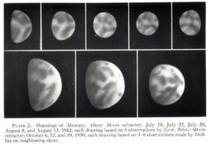
Karta-skhema tipov mestnostey Merkuriya KP Florenskiy, AT Bazilevskiy, GA Burba, VP Volkovc AV Ivanov, RO Kuzmin, MA Nazarov, OV Nikolaeva, AA Pronim, OD Rodye, OI Yakovlev, AA Yarosevskiy; Ed. VL Barsukov Otserki Sravnitel’noj Planetologii Nauka, Moskva, 1981. Vernadski Institute  

MIIGAiK’s Map of Mercury (1992)

MIIGAiK’s Map of Mercury (1992)

Source: Bugaevsky L.M., Shingareva K.B., Krasnopevtseva B.V et al. Atlas Planet Zemnoi Gruppy i ih Sputnikov («Атлас планет земной группы и их спутников».). MIIGAiK, 1992. Moscow Scale: 1:35 000 000 Note: This is a geologo-morphologic map. The Atlas contains several additional thematic maps of Mercury The online version of the Atlas is available at http://www.planetmaps.ru/ru/projects/onlineatlas […]

Dresden Map of Mercury (2005)

Dresden Map of Mercury (2005)

Title: Merkur Map editor: M.F.Buchroithner (Dresden University of Technology) Map consultants: B. V. Krasnopevtseva, K. B. Shingareva, Moscow State University for Geodesy and Cartography (MIIGAiK). Cartographers: R. Franke, R. Pässler, M. Tusche, Dr. O. Wälder Reference: Kira B. Shingareva, Jim Zimbelman, Manfred F. Buchroithner and Henrik I. Hargitai (2005): The Realization of ICA Commission Projects […]

Map of Mercury, Bilingual Edition (2004)

Map of Mercury, Bilingual Edition (2004)

Title: A Merkúr/Mercurius/Mercury Map editor: H. Hargitai Shade relief base map editors: B. V. Krasnopevtseva, K. B. Shingareva, Moscow State University for Geodesy and Cartography (MIIGAiK). Language of nomenclature: Latin Language of explanations: Hungarian, English Map type: Colored Shaded Relief and Albedo Projection: Lambert Transversal Equivalent Azimuthal Projection First Publication Date: 2004 Scale: 1:17 800 000 […]

Explanation
Column name Column description
Catalog ID (M) N/A
Title Title of map
Author Name of mapper(s), or author, PI, map editor, illustrator, etc. with roles
Nationality Nationality of author
Start date Year when mapping began / or year or observation
Date of publication Year of publication or completion of manusctipt (empty if not published yet)
Body Target name (planetary body)
Online Online references about the map
Projection Projection of map. 2-hemisphere is shown here.
Scale N/A
Orientation Orientation of map [north up, south up] – only for historic maps (north: cartographic tradition, south: astronomical tradition)
Publication type The type of work that contains the map. [standalone, journal, conference, atlas, book figure, book supplement, book plate, encyclopedia, multisheet, digital]
Type, purpose Type of map purpose [generic, outreach, science, citizen, surface operation (pre mission), landing site (post mission), observer, opposition, index, reference, eclipse/transit/occultation] generic: not defined, outreach: maps for the general public made b
Primary Nomenclature Laguage(s) of nomenclature displayed on the map [Latin, English etc., IAU, informal]. Latin for Latin nomenclature prior to IAU.
Ref (map) Full reference of map publication or publication that contains the map
DOI DOI number of map
ID (publication) ID of map publication or figure number
Origin type If this map is not original, the following codes are used: [L: language variant, N: new print, U: updated edition, C: copied / modified from another map, R: renovation map (digital version of paper map with slight changes), F facsimile. RP: republished in
Origin ID Any maps that this map is based on or copied from. Database ID of original map.
Based on map Name of mapper
Base (spacecraft, telescope) Name of spacecraft / instrument
Original title Title of map in original langage (if not English)
Publisher Name of Publisher; manuscript or self-published. For journals and conferences, the name of the journal or conference.
Coverage Coverage of map [global, hemispheric, regional, local, landing site, landing ellipse, traverse]
Target location IAU name of target feature (if named) or near side, far side etc. (If nothing noted, it is global)
Country Country of Publisher (original/translation)
Type, content Type of map [photo, map, sketch map, drawing, globe, tactile, data]. Data for raster datasets. For vector data, see Feature DB. Drawing: no grid, scale, projection etc.
Image base Base theme of the map [shaded relief, photomosaic, photo, none]
Theme Theme of map [visual, albedo, radar, low sun, topography, elevation, geology, geomorphology, art, nomenclature reference, feature, landing site reference, opposition map, event (eclipse etc) etc.]. Low sun is optical photo with shadows and no albedo. Vis
Technique Cartographic technique [imagemap, datamap, cartographic map, unit map, airbrush, pencil, line drawing/outline, contour lines, DEM, DIM, shaded relief / hillshading, raster data etc.]
Style Details on style
Method Method how the data was obtained
Mapping scale Scale of mapping
Resolution Raster dataset resoltion [m/pixel]
Short Reference Short form of reference to the map publication
GIS / data URL where GIS or original spatial data is
Data provider N/A
Profession Profession of author (for historic maps)
Designator Sheet designator terms following Greeley and Batson (1990) Planetary Mapping. Cambridge University Press. – only if displayed on the map. First letter: target body, 5M: scale, 90/0 etc: center coordinates, OM – orthophotomosaic , T – Topographic data (nom
Control Controlled, semi-controlled, uncontrolled
Note on control Base of control
Series title Title of map series
Number of maps (in work) N/A
Number of quads N/A
Quad ID Quad ID (or quads IDs) contained on the map
Map Diameter N/A
Map width cm N/A
Map height cm N/A
Map width px N/A
Map height px N/A
Base type Type of instrument of observation of base data [naked eye, telescope, spacecraft, space telescope, lander]
Location of copy Library or archive where manuscript or rare copy is kept
Ref (literature) Reference – literature about the map, may be the source of data if the map is not available. Separated with # symbols.
Status (2017) Status of mapping [complete, in progress, in review] (mostly for USGS maps)
Aim Original aim of mapping, if available
Notes Any comments, remarks [Long text, may be multiple paragraphs]
Secondary nomenclature Other languages of the nomenclature
Nomenclature Notes Remarks on nomenclature
Photo note N/A
Reference frame ID from RefFrames
web2 Online references about the map
web3 Online references about the map
web4 Online references about the map
ocentric/ographic Map coordinate [planetographic, planetocentric]
N N/A
S N/A
W 360E N/A
E 360E N/A
W 180 N/A
E 180 N/A
W 360W N/A
R 360W N/A
fig1 N/A
fig1 caption N/A
fig2 N/A
fig2 caption N/A
fig3 N/A
fig3 caption N/A
fig4 N/A
fig4 caption N/A
fig5 N/A
fig5 caption N/A
STATUS N/A
Sum $180