Searchable catalog of planetary maps from the beginning (1600) until today. This catalog aims to be complete and includes hundreds of maps not in our digital collection.
International Catalog of Planetary Maps
Citation: H. I. Hargitai, M. Pitura 2018 International Catalog of Planetary Maps 1600–2017. 49th Lunar and Planetary Science Conference 2018 (LPI Contrib. No. 2083)
Feature maps, databases and catalogs contain spatial information of a single type of geologic or other feature. We have a separate table where we collect information on where such databases are published.
Integrated Database of Planetary Features
Citation: H Hargitai 2016 Metacatalog of Planetary Surface Features for Multicriteria Evaluation of Surface Evolution: the Integrated Planetary Feature Database. DPS 48/ EPSC 11 Meeting #426.23, Pasadena, CA.
The complete database is available at https://planetarydatabase.wordpress.com/
Maps are split into smaller mapping regions called quadrangles. This table contain information on the location, identification and names of map quads.
Quads
Quadrangle information is taken from maps. For more information see: Ronald Greeley and Raymond M. Batson: Planetary Mapping (Cambridge Planetary Science)
Planetary maps are based on reference frames that define the origin of the coordinate system, the shape and size of the map surface. This table contains information on coordinate systems and reference frames for each mapped planetary body in our Solar System.
Reference Frames
For more information, see:
Henrik Hargitai, Konrad Willner and Trent Hare: Fundamental Frameworks in Planetary
Mapping: A Review
in: H. Hargitai (ed.), Planetary Cartography and GIS, Lecture Notes in Geoinformation
and Cartography, https://doi.org/10.1007/978-3-319-62849-3_4
Name of mapper(s), or author, PI, map editor, illustrator, etc. with roles
Nationality
Nationality of author
Start date
Year when mapping began / or year or observation
Date of publication
Year of publication or completion of manusctipt (empty if not published yet)
Body
Target name (planetary body)
Online
Online references about the map
Projection
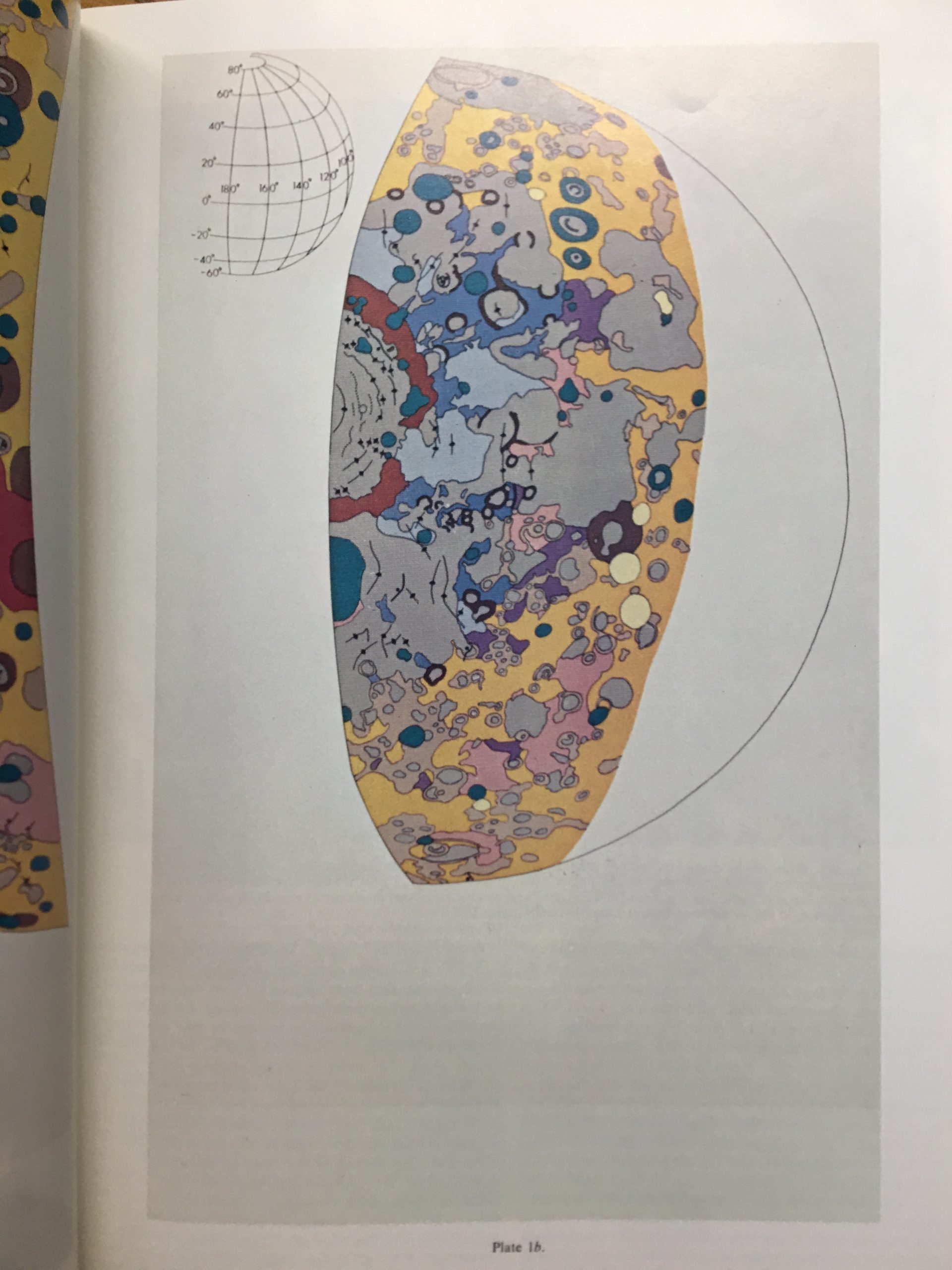
Projection of map. 2-hemisphere is shown here.
Scale
N/A
Orientation
Orientation of map [north up, south up] – only for historic maps (north: cartographic tradition, south: astronomical tradition)
Publication type
The type of work that contains the map. [standalone, journal, conference, atlas, book figure, book supplement, book plate, encyclopedia, multisheet, digital]
Type, purpose
Type of map purpose [generic, outreach, science, citizen, surface operation (pre mission), landing site (post mission), observer, opposition, index, reference, eclipse/transit/occultation] generic: not defined, outreach: maps for the general public made b
Primary Nomenclature
Laguage(s) of nomenclature displayed on the map [Latin, English etc., IAU, informal]. Latin for Latin nomenclature prior to IAU.
Ref (map)
Full reference of map publication or publication that contains the map
DOI
DOI number of map
ID (publication)
ID of map publication or figure number
Origin type
If this map is not original, the following codes are used: [L: language variant, N: new print, U: updated edition, C: copied / modified from another map, R: renovation map (digital version of paper map with slight changes), F facsimile. RP: republished in
Origin ID
Any maps that this map is based on or copied from. Database ID of original map.
Based on map
Name of mapper
Base (spacecraft, telescope)
Name of spacecraft / instrument
Original title
Title of map in original langage (if not English)
Publisher
Name of Publisher; manuscript or self-published. For journals and conferences, the name of the journal or conference.
IAU name of target feature (if named) or near side, far side etc. (If nothing noted, it is global)
Country
Country of Publisher (original/translation)
Type, content
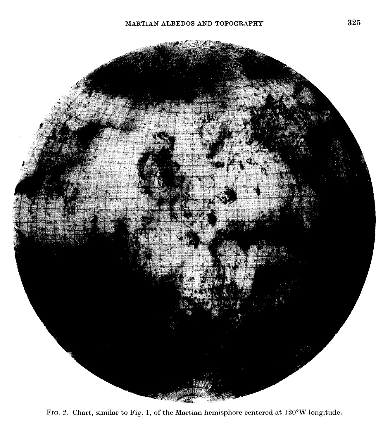
Type of map [photo, map, sketch map, drawing, globe, tactile, data]. Data for raster datasets. For vector data, see Feature DB. Drawing: no grid, scale, projection etc.
Image base
Base theme of the map [shaded relief, photomosaic, photo, none]
Theme
Theme of map [visual, albedo, radar, low sun, topography, elevation, geology, geomorphology, art, nomenclature reference, feature, landing site reference, opposition map, event (eclipse etc) etc.]. Low sun is optical photo with shadows and no albedo. Vis
Technique
Cartographic technique [imagemap, datamap, cartographic map, unit map, airbrush, pencil, line drawing/outline, contour lines, DEM, DIM, shaded relief / hillshading, raster data etc.]
Style
Details on style
Method
Method how the data was obtained
Mapping scale
Scale of mapping
Resolution
Raster dataset resoltion [m/pixel]
Short Reference
Short form of reference to the map publication
GIS / data
URL where GIS or original spatial data is
Data provider
N/A
Profession
Profession of author (for historic maps)
Designator
Sheet designator terms following Greeley and Batson (1990) Planetary Mapping. Cambridge University Press. – only if displayed on the map. First letter: target body, 5M: scale, 90/0 etc: center coordinates, OM – orthophotomosaic , T – Topographic data (nom
Control
Controlled, semi-controlled, uncontrolled
Note on control
Base of control
Series title
Title of map series
Number of maps (in work)
N/A
Number of quads
N/A
Quad ID
Quad ID (or quads IDs) contained on the map
Map Diameter
N/A
Map width cm
N/A
Map height cm
N/A
Map width px
N/A
Map height px
N/A
Base type
Type of instrument of observation of base data [naked eye, telescope, spacecraft, space telescope, lander]
Location of copy
Library or archive where manuscript or rare copy is kept
Ref (literature)
Reference – literature about the map, may be the source of data if the map is not available. Separated with # symbols.
Status (2017)
Status of mapping [complete, in progress, in review] (mostly for USGS maps)
Aim
Original aim of mapping, if available
Notes
Any comments, remarks [Long text, may be multiple paragraphs]