1950

Lowell Observatory map of Mars 1962

Lowell Observatory map of Mars 1962

G. de Vaucouleurs: Precision mapping of Mars. In: Physics of Planets. Proceedings of the 11th International Astrophysical Symposium Liege, July 9-12, 1962. 369- Bad image quality due to scanning, original paper version is not available.

Dollfus’ Mars Polar Cap Map 1956

Dollfus’ Mars Polar Cap Map 1956

The two extremes of the south polar cap of Mars in 1956. (Pic du Midi, Dollfus). In: Dollfus, A. 1965  Étude de la planète Mars de 1954 à 1958 Annales d’Astrophysique, Vol. 28, p.722

McLaughlin’s wind map of Mars (1954)

  Source McLaughlin, D. B.: Wind patterns and volcanoes on Mars. The Observatory, Vol. 74, p. 166-168 (1954) McLaughlin, D. B.: Interpretation of Some Martian Features. Publications of the Astronomical Society of the Pacific, Vol. 66, No. 391, p.161

Mottoni’s albedo synthesis maps of Mars

Mottoni’s albedo synthesis maps of Mars

De Mottoni Y Palacios, G. (1975). The appearance of Mars from 1907 to 1971: Graphic synthesis of photographs from the I.A.U. center at Meudon. Icarus, 25(2), 296–332   Note: we display these maps north-up.

Lopez and Escalante’s maps of Mars (1956)

Lopez and Escalante’s maps of Mars (1956)

Escalante Lopez López E, Escalante FJ 1963 El planeta Marte : 1907-1956 ; areografía, areología, bioareografía y climatología, la vida en su superficie. Mexico DF p52

Early maps of Mercury

Early maps of Mercury

A summary of Mercury mapping, early drawings reprojected uniformly into Mollweide projection. The last map is based on photographic studies in 1942-1948. (Note: This caption wronly identifies Venus as the mapped object. It is Mercury).   1942-1948 Dollfus, A 1889 Schiaparelli Astr. Nach. 1889 p 246 1897 Lowell Mem. Amer. o Arts and Sciences 1897 […]

ALPO map of Mars

ALPO map of Mars

1954 Association of Lunar and Planetary Observers (A.L.P.O.) 1954 Source   1960 Both, Ernst E., A.L.P.O. Map of Mars for 1960-1961   These maps are updated regularly. See http://www.alpo-astronomy.org/jbeish/Observing_Mars_4.html

Rand McNally’s Official Maps of the Moon (1958-)

Rand McNally’s Official Maps of the Moon (1958-)

The 1958 edition includes the Physiographic division of the Moon that was published only in 1961. Background: ACIC. 1958 edition, printed in Japan 1969 edition Far side of the Moon: M 1:5.5M. Shaded relief aibrush map, based on Lunar Orbiter I-V images.  1969 Apollo landing sites 1969

Barabashev’s drawing of Mars

Barabashev’s drawing of Mars

Reproduced in Kulin-Zerinváry: A távcső világa. Budapest, 1958. Courtesy of I. Almar   ” In the 1920-1926 yrs. with the help of a 270-millimeter reflector NP Barabashov conducted a large number of visual observations of Mars in different spectral ranges, the result of which was the compilation of a map of the planet’s surface.” (Wikipedia, Russian version)  

Temperature map of the Moon

Temperature map of the Moon

Source: Zerinváry Szilárd: A Naprendszer élete. Művelt Nép Könyvkiadó, 1953, Budapest Origin of the map unknown. Caption: Temperature values on the Moon in the Sun-facing hemisphere.    

Focas’ drawing of Mars 1958

Drawing by J. H. FOcas, Pic du Midi, 1958 Jean-Henri Focas Source: A. Dollfus: Visual and photographic studies off planets at the Pic du Midi. In: Planets and Satellites, GP Kuiper and B Middlehurst, eds. Chicago Univ Press 543-571.

Pic du Midi drawings and map of Mercury

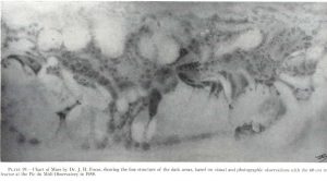
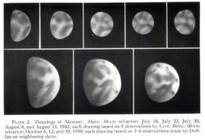
Upper row: 1942, Lyot – 25 drawings, 36 inch refractor, 300-500x magnification. Lower row: 1950, A Dollfus, 60-inch refractor, 750-900x magnification Lyot and Camichel, 1942:  Map from 12 composites. 23 markings were measured. Source: A. Dollfus: Visual and photographic studies off planets at the Pic du Midi. In: Planets and Satellites, GP Kuiper and B […]

Explanation
Column name Column description
Catalog ID (M) N/A
Title Title of map
Author Name of mapper(s), or author, PI, map editor, illustrator, etc. with roles
Nationality Nationality of author
Start date Year when mapping began / or year or observation
Date of publication Year of publication or completion of manusctipt (empty if not published yet)
Body Target name (planetary body)
Online Online references about the map
Projection Projection of map. 2-hemisphere is shown here.
Scale N/A
Orientation Orientation of map [north up, south up] – only for historic maps (north: cartographic tradition, south: astronomical tradition)
Publication type The type of work that contains the map. [standalone, journal, conference, atlas, book figure, book supplement, book plate, encyclopedia, multisheet, digital]
Type, purpose Type of map purpose [generic, outreach, science, citizen, surface operation (pre mission), landing site (post mission), observer, opposition, index, reference, eclipse/transit/occultation] generic: not defined, outreach: maps for the general public made b
Primary Nomenclature Laguage(s) of nomenclature displayed on the map [Latin, English etc., IAU, informal]. Latin for Latin nomenclature prior to IAU.
Ref (map) Full reference of map publication or publication that contains the map
DOI DOI number of map
ID (publication) ID of map publication or figure number
Origin type If this map is not original, the following codes are used: [L: language variant, N: new print, U: updated edition, C: copied / modified from another map, R: renovation map (digital version of paper map with slight changes), F facsimile. RP: republished in
Origin ID Any maps that this map is based on or copied from. Database ID of original map.
Based on map Name of mapper
Base (spacecraft, telescope) Name of spacecraft / instrument
Original title Title of map in original langage (if not English)
Publisher Name of Publisher; manuscript or self-published. For journals and conferences, the name of the journal or conference.
Coverage Coverage of map [global, hemispheric, regional, local, landing site, landing ellipse, traverse]
Target location IAU name of target feature (if named) or near side, far side etc. (If nothing noted, it is global)
Country Country of Publisher (original/translation)
Type, content Type of map [photo, map, sketch map, drawing, globe, tactile, data]. Data for raster datasets. For vector data, see Feature DB. Drawing: no grid, scale, projection etc.
Image base Base theme of the map [shaded relief, photomosaic, photo, none]
Theme Theme of map [visual, albedo, radar, low sun, topography, elevation, geology, geomorphology, art, nomenclature reference, feature, landing site reference, opposition map, event (eclipse etc) etc.]. Low sun is optical photo with shadows and no albedo. Vis
Technique Cartographic technique [imagemap, datamap, cartographic map, unit map, airbrush, pencil, line drawing/outline, contour lines, DEM, DIM, shaded relief / hillshading, raster data etc.]
Style Details on style
Method Method how the data was obtained
Mapping scale Scale of mapping
Resolution Raster dataset resoltion [m/pixel]
Short Reference Short form of reference to the map publication
GIS / data URL where GIS or original spatial data is
Data provider N/A
Profession Profession of author (for historic maps)
Designator Sheet designator terms following Greeley and Batson (1990) Planetary Mapping. Cambridge University Press. – only if displayed on the map. First letter: target body, 5M: scale, 90/0 etc: center coordinates, OM – orthophotomosaic , T – Topographic data (nom
Control Controlled, semi-controlled, uncontrolled
Note on control Base of control
Series title Title of map series
Number of maps (in work) N/A
Number of quads N/A
Quad ID Quad ID (or quads IDs) contained on the map
Map Diameter N/A
Map width cm N/A
Map height cm N/A
Map width px N/A
Map height px N/A
Base type Type of instrument of observation of base data [naked eye, telescope, spacecraft, space telescope, lander]
Location of copy Library or archive where manuscript or rare copy is kept
Ref (literature) Reference – literature about the map, may be the source of data if the map is not available. Separated with # symbols.
Status (2017) Status of mapping [complete, in progress, in review] (mostly for USGS maps)
Aim Original aim of mapping, if available
Notes Any comments, remarks [Long text, may be multiple paragraphs]
Secondary nomenclature Other languages of the nomenclature
Nomenclature Notes Remarks on nomenclature
Photo note N/A
Reference frame ID from RefFrames
web2 Online references about the map
web3 Online references about the map
web4 Online references about the map
ocentric/ographic Map coordinate [planetographic, planetocentric]
N N/A
S N/A
W 360E N/A
E 360E N/A
W 180 N/A
E 180 N/A
W 360W N/A
R 360W N/A
fig1 N/A
fig1 caption N/A
fig2 N/A
fig2 caption N/A
fig3 N/A
fig3 caption N/A
fig4 N/A
fig4 caption N/A
fig5 N/A
fig5 caption N/A
STATUS N/A
Sum $180