Moon

The first photoelectronic (albedo) map of the Moon

These are the first maps where photographic albedo was converted into exact numerical values. Source: A photoelectric-photographic study of the normal albedo of the Moon, accompanied by an Albedo map of the Moon 1970 https://pubs.er.usgs.gov/publication/pp599E

Paleogeographic map of the Moon (1971)

Paleogeographic map of the Moon (1971)

Drawings by Don Davis. Middle Imbrian End of Imbrian 3.3 Ga Today

Unified Geologic Map of the Moon, 1:5M (2020)

Unified Geologic Map of the Moon, 1:5M (2020)

Original comment: “This new work represents a seamless, globally consistent, 1:5,000,000-scale geologic map derived from the six digitally renovated geologic maps … The product overlies shaded-relief products derived from SELENE Kaguya terrain camera stereo (equatorial, ~60 m/pix) and LOLA altimetry (north and south polar, 100 m/pix).” Source: https://astrogeology.usgs.gov/search/map/Moon/Geology/Unified_Geologic_Map_of_the_Moon_GIS GIS is included in the original release. […]

Elger’s map of the Moon

Elger’s map of the Moon

Donald Grant’s plastic map of the Moon

Donald Grant’s plastic map of the Moon

Das Weltall. Meyers Kinderbibliotek 1998 (German), Atlas of Space (First Discovery/Atlas) (English) / Atlas du ciel (French Edition) 1995

Scott’s Apollo Moon Map (2017)

Scott’s Apollo Moon Map (2017)

Scott, Zack Apollo Der Wettlauf zum Mond. Droemer. / Apollo: The extraordinary visual history of the iconic space programme 2017 Wildfire

Dresden map of the Moon

Dresden map of the Moon

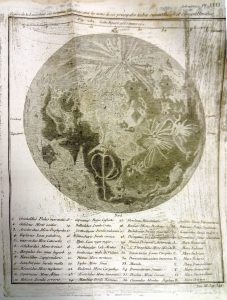
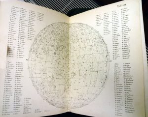
Buchroithner M.F.(Dresden University of Technology), B. V. Krasnopevtseva, K. B. Shingareva, Moscow State University for Geodesy and Cartography (MIIGAiK). Cartographers: R. Franke, R. Pässler, M. Tusche, Ch. Walter Republications: Mackowiak, Bernhard, Astronomie. Naumann & Göbel; 1., Auflage edition

Die sichtbare Seite der Mond-Oberfläche

Die sichtbare Seite der Mond-Oberfläche

Vollständiger Hand-Atlas der neueren Erdbeschreibung ueber alle Theile der Erde : in 80 Blättern / herausgegeben von K. Sohr 1844, Carl Flemming  

Mond—Karte Nach dem besten Quellen entworfen und gezeichnet

Mond—Karte Nach dem besten Quellen entworfen und gezeichnet

Meyer’s Kriegs- u. Friedens- oder grosser Zeitungs-Atlas in 148 karten… J. Meyer. Hildburohausen et New-York . Schleifmann sc 1860

La Lande’s map of the Moon

Astronomie par Jerome le Francaus (La Lande) – Troisieme edition, revue et augmentée, Paris, Desaint, Didot L’Ainé, MDCCXCII

Hevelius’ base map of the Moon

Johnnis Hevelii Machinae Coelestis pars posteriori rerum uranicarum observationes….. Simon Reininger, Gedani 1679

Littrow 1878

Littrow JJ, Littrow Karl 1878 Die Wunder des Himmels. Berlin, Verlan von Gustav Hempel. Sechste auflage

Explanation
Column name Column description
Catalog ID (M) N/A
Title Title of map
Author Name of mapper(s), or author, PI, map editor, illustrator, etc. with roles
Nationality Nationality of author
Start date Year when mapping began / or year or observation
Date of publication Year of publication or completion of manusctipt (empty if not published yet)
Body Target name (planetary body)
Online Online references about the map
Projection Projection of map. 2-hemisphere is shown here.
Scale N/A
Orientation Orientation of map [north up, south up] – only for historic maps (north: cartographic tradition, south: astronomical tradition)
Publication type The type of work that contains the map. [standalone, journal, conference, atlas, book figure, book supplement, book plate, encyclopedia, multisheet, digital]
Type, purpose Type of map purpose [generic, outreach, science, citizen, surface operation (pre mission), landing site (post mission), observer, opposition, index, reference, eclipse/transit/occultation] generic: not defined, outreach: maps for the general public made b
Primary Nomenclature Laguage(s) of nomenclature displayed on the map [Latin, English etc., IAU, informal]. Latin for Latin nomenclature prior to IAU.
Ref (map) Full reference of map publication or publication that contains the map
DOI DOI number of map
ID (publication) ID of map publication or figure number
Origin type If this map is not original, the following codes are used: [L: language variant, N: new print, U: updated edition, C: copied / modified from another map, R: renovation map (digital version of paper map with slight changes), F facsimile. RP: republished in
Origin ID Any maps that this map is based on or copied from. Database ID of original map.
Based on map Name of mapper
Base (spacecraft, telescope) Name of spacecraft / instrument
Original title Title of map in original langage (if not English)
Publisher Name of Publisher; manuscript or self-published. For journals and conferences, the name of the journal or conference.
Coverage Coverage of map [global, hemispheric, regional, local, landing site, landing ellipse, traverse]
Target location IAU name of target feature (if named) or near side, far side etc. (If nothing noted, it is global)
Country Country of Publisher (original/translation)
Type, content Type of map [photo, map, sketch map, drawing, globe, tactile, data]. Data for raster datasets. For vector data, see Feature DB. Drawing: no grid, scale, projection etc.
Image base Base theme of the map [shaded relief, photomosaic, photo, none]
Theme Theme of map [visual, albedo, radar, low sun, topography, elevation, geology, geomorphology, art, nomenclature reference, feature, landing site reference, opposition map, event (eclipse etc) etc.]. Low sun is optical photo with shadows and no albedo. Vis
Technique Cartographic technique [imagemap, datamap, cartographic map, unit map, airbrush, pencil, line drawing/outline, contour lines, DEM, DIM, shaded relief / hillshading, raster data etc.]
Style Details on style
Method Method how the data was obtained
Mapping scale Scale of mapping
Resolution Raster dataset resoltion [m/pixel]
Short Reference Short form of reference to the map publication
GIS / data URL where GIS or original spatial data is
Data provider N/A
Profession Profession of author (for historic maps)
Designator Sheet designator terms following Greeley and Batson (1990) Planetary Mapping. Cambridge University Press. – only if displayed on the map. First letter: target body, 5M: scale, 90/0 etc: center coordinates, OM – orthophotomosaic , T – Topographic data (nom
Control Controlled, semi-controlled, uncontrolled
Note on control Base of control
Series title Title of map series
Number of maps (in work) N/A
Number of quads N/A
Quad ID Quad ID (or quads IDs) contained on the map
Map Diameter N/A
Map width cm N/A
Map height cm N/A
Map width px N/A
Map height px N/A
Base type Type of instrument of observation of base data [naked eye, telescope, spacecraft, space telescope, lander]
Location of copy Library or archive where manuscript or rare copy is kept
Ref (literature) Reference – literature about the map, may be the source of data if the map is not available. Separated with # symbols.
Status (2017) Status of mapping [complete, in progress, in review] (mostly for USGS maps)
Aim Original aim of mapping, if available
Notes Any comments, remarks [Long text, may be multiple paragraphs]
Secondary nomenclature Other languages of the nomenclature
Nomenclature Notes Remarks on nomenclature
Photo note N/A
Reference frame ID from RefFrames
web2 Online references about the map
web3 Online references about the map
web4 Online references about the map
ocentric/ographic Map coordinate [planetographic, planetocentric]
N N/A
S N/A
W 360E N/A
E 360E N/A
W 180 N/A
E 180 N/A
W 360W N/A
R 360W N/A
fig1 N/A
fig1 caption N/A
fig2 N/A
fig2 caption N/A
fig3 N/A
fig3 caption N/A
fig4 N/A
fig4 caption N/A
fig5 N/A
fig5 caption N/A
STATUS N/A
Sum $180