The Collection

Solar albedo global map of Mars from OMEGA

Filled Albedo Mars map from poster by J. Audouard, M. Vincendon, F. Poulet and B. Gondet presented on The 48th Lunar and Planetary Science Conference. Link to poster: https://www.hou.usra.edu/meetings/lpsc2017/eposter/1980.pdf

Children’s map of Pluto and Charon

Illustrator: Adrienn Gyöngyösi Main text written by Ross Beyer. Editor Henrik Hargitai Publisher: ELTE University, Budapest Date: 2016

Focas’ drawing of Mars 1958

Drawing by J. H. FOcas, Pic du Midi, 1958 Jean-Henri Focas Source: A. Dollfus: Visual and photographic studies off planets at the Pic du Midi. In: Planets and Satellites, GP Kuiper and B Middlehurst, eds. Chicago Univ Press 543-571.

Pic du Midi drawings and map of Mercury

Upper row: 1942, Lyot – 25 drawings, 36 inch refractor, 300-500x magnification. Lower row: 1950, A Dollfus, 60-inch refractor, 750-900x magnification Lyot and Camichel, 1942:  Map from 12 composites. 23 markings were measured. Source: A. Dollfus: Visual and photographic studies off planets at the Pic du Midi. In: Planets and Satellites, GP Kuiper and B […]

Map of the Volcanic Forms of the Moon (1974)

Source: Academy of Sciences of the USSR, Order of the Red Banner of Labour Geological Institute: Volcanism and Tectonics of the Mon. Nauka, Moscow 1974. Editors: AV Peive, VV Menner, VG Gerbova, PP Tomofeev, MS Markov. Карта вулкавических форм Луны А – схема расnоложенuя лuстов карты 1 – кратеры вулканичесного происхождения; 2 – нратеры предположитепьио […]

Comparative infographics

The giant volcano Olympus and some terrestrial volcanoes. Source: В. Н. Губин Дистанционные методы в геологии. Курс лекций. МИНСК БГУ 2004.   Иллюстрации из наглядного пособия А. А. Михайлова «Луна — ближайшее к нам небесное светило» (М.: Гос. изд — во культурно — просветительной литературы, 1946): относительные размеры Луны и Земли, проекция Луны на земную поверхность и карта Луны. […]

Phobos Atlas (DLR) (2008)

Controlled Mosaic of Phobos 4 Quads Editors: Oberst, J, DLR. Photogrammetry: Oberst J, Willner K., Cartography: Semm S, Wahlisch M References: Konrad Willner: The Martian Moon Phobos A Geodetic Analysis of its Motion, Orientation, Shape, and Physical Parameters. Berlin 2009 M.Wählisch et al 2010  A new topographic image atlas of Phobos

Geomorphologic Map Mars series (DLR/TU/FU Berlin)

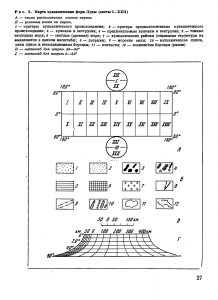
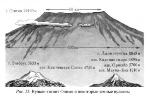
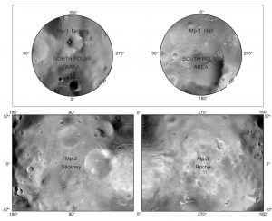
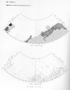
1:300,000 Series The geomorphologic map sheet of the Centauri and Hellas Montes area. Editors: Albertz J, Jaumann R, Neukum G. TU Berlin, DLR, FU Berlin. 2006 Source: Gwinner et al. 2016 1:600,000 Series ID: M 600k 34.50S/323.75E OMKG Hale-Bond Region, Mars. Source:  J.Albertz, S. Gehrke, H. Lehmann, M. Wählisch : FOUR YEARS OF PLANETARY CARTOGRAPHY WITH THE […]

Map of Mars showing channels and possible paleolake basins (1995)

Map of Mars showing channels and possible paleolake basins (1995)

(Detail) D.H. Scott, J.M. Dohm, and J. W. Rice Jr. 1995  Map of Mars showing channels and possible paleolake basins. IMAP 2461. USGS. https://pubs.er.usgs.gov/publication/i2461

Crater maps of Mars 1976

Geologic and crater sketch maps of Mars, all quadrangles. In: Mutch et al. The Geology of Mars. 1976

Sketch maps of Zond-3 probe images

Sketch maps of Zond-3 probe images

Дешифрование снимков полоценных амс зонд-3 составление карты-схемы и каталога выявленных образований. In: Атлас обратной строны луны часть II Atlas of the far side of the Moon, Part II. Moscow 1967. p 33-64.

Paleogeographic maps of Mars (1976)

Paleogeographic maps of Mars (1976)

Schematic paleomaps of the eastern hemisphere of Mars. Mutch et al. 1976, p. 317 Mutch, T. A. & Saunders, R. S.: The geologic development of Mars – A review. Space Science Reviews, vol. 19, June 1976, p. 3-57.