Chart of Mars (1892)

ball_1892

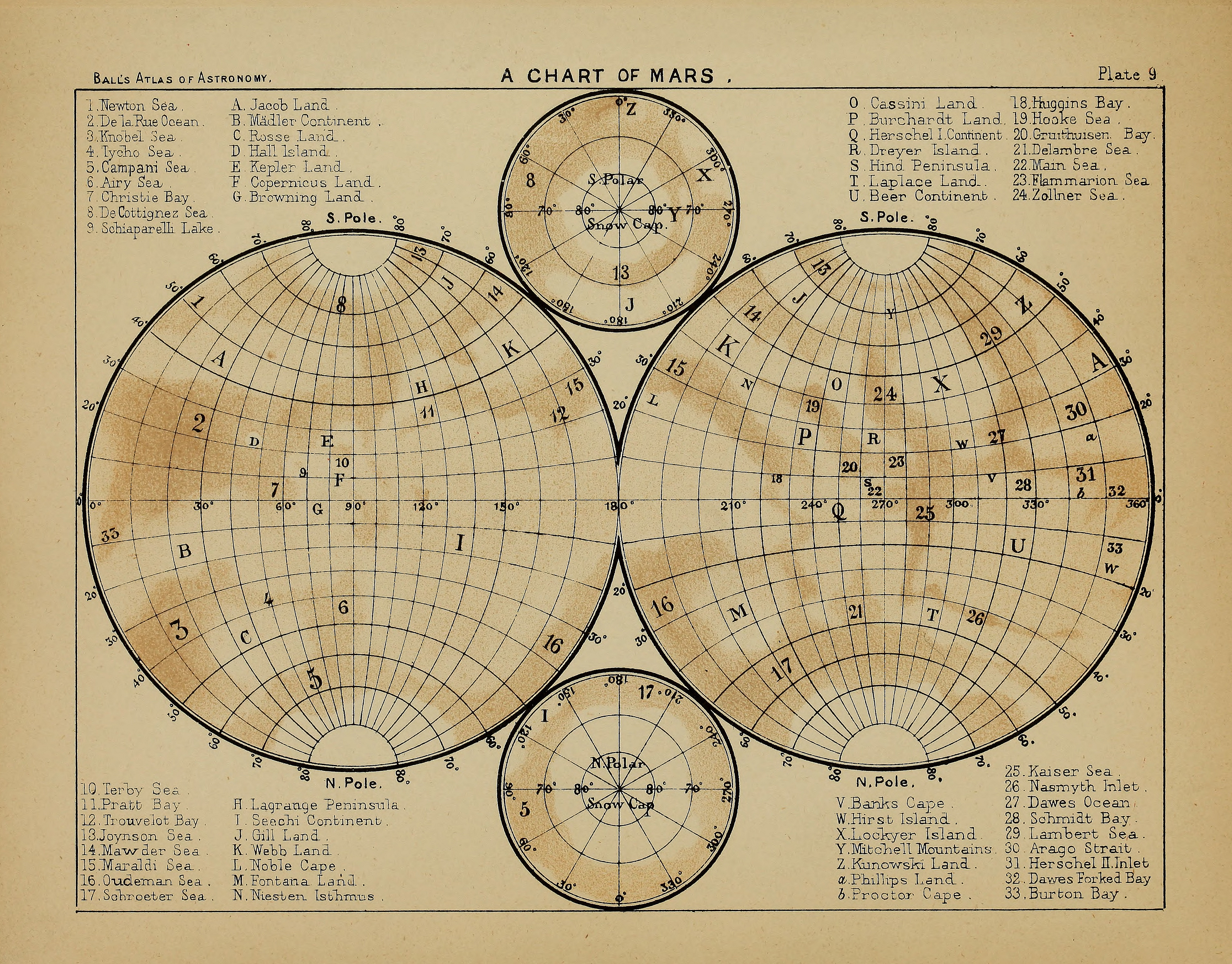
“This map represents the surface of Mars on the stereographic projection. It has been compiled (with only two exceptions, where, as shown by Mr. Knobel in 1884, the balance of evidence appears to incline otherwise) from Mr. N. E. Green’s Chart of Mars, published in theTransactions of the Royal Astronomical Society, Vol. XLIV. The details of this chart have been compared with views of the planet by Schiaparelli, Trouvelot, Terby, De la Rue, Lockyer, Knobel, Christie, Maunder, Brett, Dreyer, and others, and no form is introduced that has not been confirmed by the drawings of at least three observers, so that any markings to be found there may be taken to represent a real feature of the planet. The exceptions to which I have referred are called by Mr. Green — Phillips Island and Leverrier Land. The first of these appears to be connected by a tongue of land between Burton Bay and Dawes Forked Bay with Beer Continent. I have consequently changed the name to Phillips Land ; and Herschel II. Strait, which by the same alteration ceases to be a strait, I have called Herschel II. Inlet. Leverrier Land I have omitted altogether, as Mr. Knobel was unable to find any trace of it under very favourable circumstances in 1884. The Lassell Sea, too, of Mr. Green appears to be only a prolongation of Nasmyth Inlet, and the name has been accordingly omitted. The smaller maps at the top and bottom of the plate are also on the stereographic projec- tion, and represent the polar regions of the planet, showing the form and extent of the northern and southern snow-caps as seen by Mr. Green in 1877. In comparing this plate with the appearance of the planet in the telescope, it should be remembered that parts near the centre of the maps are by this method of projection represented on a smaller scale than those near the edge.”

Published in: Ball, R.S. 1892; An atlas of astronomy – a series of seventy-two plates, with introduction and index; New York. Plate IX.

Language: English

Courtesy Ton Lindemann.

Explanation
Column name Column description
Catalog ID (M) N/A
Title Title of map
Author Name of mapper(s), or author, PI, map editor, illustrator, etc. with roles
Nationality Nationality of author
Start date Year when mapping began / or year or observation
Date of publication Year of publication or completion of manusctipt (empty if not published yet)
Body Target name (planetary body)
Online Online references about the map
Projection Projection of map. 2-hemisphere is shown here.
Scale N/A
Orientation Orientation of map [north up, south up] – only for historic maps (north: cartographic tradition, south: astronomical tradition)
Publication type The type of work that contains the map. [standalone, journal, conference, atlas, book figure, book supplement, book plate, encyclopedia, multisheet, digital]
Type, purpose Type of map purpose [generic, outreach, science, citizen, surface operation (pre mission), landing site (post mission), observer, opposition, index, reference, eclipse/transit/occultation] generic: not defined, outreach: maps for the general public made b
Primary Nomenclature Laguage(s) of nomenclature displayed on the map [Latin, English etc., IAU, informal]. Latin for Latin nomenclature prior to IAU.
Ref (map) Full reference of map publication or publication that contains the map
DOI DOI number of map
ID (publication) ID of map publication or figure number
Origin type If this map is not original, the following codes are used: [L: language variant, N: new print, U: updated edition, C: copied / modified from another map, R: renovation map (digital version of paper map with slight changes), F facsimile. RP: republished in
Origin ID Any maps that this map is based on or copied from. Database ID of original map.
Based on map Name of mapper
Base (spacecraft, telescope) Name of spacecraft / instrument
Original title Title of map in original langage (if not English)
Publisher Name of Publisher; manuscript or self-published. For journals and conferences, the name of the journal or conference.
Coverage Coverage of map [global, hemispheric, regional, local, landing site, landing ellipse, traverse]
Target location IAU name of target feature (if named) or near side, far side etc. (If nothing noted, it is global)
Country Country of Publisher (original/translation)
Type, content Type of map [photo, map, sketch map, drawing, globe, tactile, data]. Data for raster datasets. For vector data, see Feature DB. Drawing: no grid, scale, projection etc.
Image base Base theme of the map [shaded relief, photomosaic, photo, none]
Theme Theme of map [visual, albedo, radar, low sun, topography, elevation, geology, geomorphology, art, nomenclature reference, feature, landing site reference, opposition map, event (eclipse etc) etc.]. Low sun is optical photo with shadows and no albedo. Vis
Technique Cartographic technique [imagemap, datamap, cartographic map, unit map, airbrush, pencil, line drawing/outline, contour lines, DEM, DIM, shaded relief / hillshading, raster data etc.]
Style Details on style
Method Method how the data was obtained
Mapping scale Scale of mapping
Resolution Raster dataset resoltion [m/pixel]
Short Reference Short form of reference to the map publication
GIS / data URL where GIS or original spatial data is
Data provider N/A
Profession Profession of author (for historic maps)
Designator Sheet designator terms following Greeley and Batson (1990) Planetary Mapping. Cambridge University Press. – only if displayed on the map. First letter: target body, 5M: scale, 90/0 etc: center coordinates, OM – orthophotomosaic , T – Topographic data (nom
Control Controlled, semi-controlled, uncontrolled
Note on control Base of control
Series title Title of map series
Number of maps (in work) N/A
Number of quads N/A
Quad ID Quad ID (or quads IDs) contained on the map
Map Diameter N/A
Map width cm N/A
Map height cm N/A
Map width px N/A
Map height px N/A
Base type Type of instrument of observation of base data [naked eye, telescope, spacecraft, space telescope, lander]
Location of copy Library or archive where manuscript or rare copy is kept
Ref (literature) Reference – literature about the map, may be the source of data if the map is not available. Separated with # symbols.
Status (2017) Status of mapping [complete, in progress, in review] (mostly for USGS maps)
Aim Original aim of mapping, if available
Notes Any comments, remarks [Long text, may be multiple paragraphs]
Secondary nomenclature Other languages of the nomenclature
Nomenclature Notes Remarks on nomenclature
Photo note N/A
Reference frame ID from RefFrames
web2 Online references about the map
web3 Online references about the map
web4 Online references about the map
ocentric/ographic Map coordinate [planetographic, planetocentric]
N N/A
S N/A
W 360E N/A
E 360E N/A
W 180 N/A
E 180 N/A
W 360W N/A
R 360W N/A
fig1 N/A
fig1 caption N/A
fig2 N/A
fig2 caption N/A
fig3 N/A
fig3 caption N/A
fig4 N/A
fig4 caption N/A
fig5 N/A
fig5 caption N/A
STATUS N/A
Sum $180