The first radar map of Venus

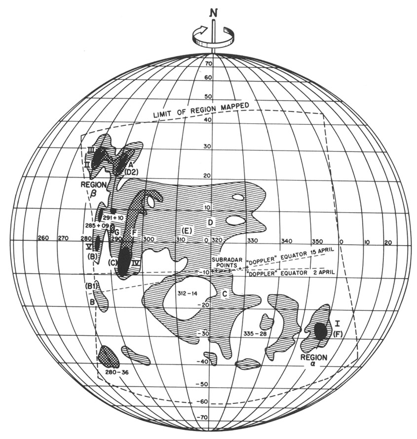
“Diagram of Venus surface features made with the Haystack-Westford interferometer. Features observed with the Haystack-Westford interferometer are indicated variously by capital letters, Roman numerals, and coordinate numbers. Goldstein’s Alpha and Beta regions are indicated (Region Greek letter alpha and Region Greek letter beta), while the labels given by Carpenter are shown in parentheses. (Courtesy of Alan E. E. Rogers.)” (source: https://history.nasa.gov/SP-4218/ch5.htm)

One of the first range-Doppler image of Venus made with a radar interferometer, the Haystack and Westford antennas in tandem, in 1967. Not only are the Alpha and Beta regions discernible, but the complexity of Beta is revealed. (Courtesy of Alan E. E. Rogers.)

Alan Rogers and Dick Ingalls also studied Venus during the 1967 inferior conjunction with the Hayford interferometer and identified eight surface regions. Just as each previous radar astronomer had invented his own nomenclature, they labeled features with Roman numerals and letters. The features of which they were certain became Haystack I through Haystack IV. The probable regions were Haystack A through Haystack D. Five of these eight regions corresponded to features already observed by either Goldstein or Carpenter. Haystack I appeared to be Goldstein’s Greek letter alpha and Carpenter’s F, while Haystack II matched Goldstein’s Greek letter beta (Table 2). Jurgens’ Arecibo results had not yet been published.67

Alan Rogers and Dick Ingalls then published a map of Venus showing the correlation of Haystack and JPL features in a 1969 issue of Science.68 The Greek letter beta region now appeared to be large and complex. The Hayford radar interferometer confirmed and extended the observations of Goldstein and Carpenter. With interferometer data taken during the 1969 and 1972 conjunctions using an instrument with a lower system noise temperature, Alan Rogers and Dick Ingalls refined their map of Venus; the data continued to indicate agreement among the Haystack and JPL features.69

Published in: Rogers, A. E. E., & Ingalls, R. P. (1969). Venus: Mapping the Surface Reflectivity by Radar Interferometry. Science, 165(3895), 797–799. doi:10.1126/science.165.3895.79

Explanation
Column name Column description
Catalog ID (M) N/A
Title Title of map
Author Name of mapper(s), or author, PI, map editor, illustrator, etc. with roles
Nationality Nationality of author
Start date Year when mapping began / or year or observation
Date of publication Year of publication or completion of manusctipt (empty if not published yet)
Body Target name (planetary body)
Online Online references about the map
Projection Projection of map. 2-hemisphere is shown here.
Scale N/A
Orientation Orientation of map [north up, south up] – only for historic maps (north: cartographic tradition, south: astronomical tradition)
Publication type The type of work that contains the map. [standalone, journal, conference, atlas, book figure, book supplement, book plate, encyclopedia, multisheet, digital]
Type, purpose Type of map purpose [generic, outreach, science, citizen, surface operation (pre mission), landing site (post mission), observer, opposition, index, reference, eclipse/transit/occultation] generic: not defined, outreach: maps for the general public made b
Primary Nomenclature Laguage(s) of nomenclature displayed on the map [Latin, English etc., IAU, informal]. Latin for Latin nomenclature prior to IAU.
Ref (map) Full reference of map publication or publication that contains the map
DOI DOI number of map
ID (publication) ID of map publication or figure number
Origin type If this map is not original, the following codes are used: [L: language variant, N: new print, U: updated edition, C: copied / modified from another map, R: renovation map (digital version of paper map with slight changes), F facsimile. RP: republished in
Origin ID Any maps that this map is based on or copied from. Database ID of original map.
Based on map Name of mapper
Base (spacecraft, telescope) Name of spacecraft / instrument
Original title Title of map in original langage (if not English)
Publisher Name of Publisher; manuscript or self-published. For journals and conferences, the name of the journal or conference.
Coverage Coverage of map [global, hemispheric, regional, local, landing site, landing ellipse, traverse]
Target location IAU name of target feature (if named) or near side, far side etc. (If nothing noted, it is global)
Country Country of Publisher (original/translation)
Type, content Type of map [photo, map, sketch map, drawing, globe, tactile, data]. Data for raster datasets. For vector data, see Feature DB. Drawing: no grid, scale, projection etc.
Image base Base theme of the map [shaded relief, photomosaic, photo, none]
Theme Theme of map [visual, albedo, radar, low sun, topography, elevation, geology, geomorphology, art, nomenclature reference, feature, landing site reference, opposition map, event (eclipse etc) etc.]. Low sun is optical photo with shadows and no albedo. Vis
Technique Cartographic technique [imagemap, datamap, cartographic map, unit map, airbrush, pencil, line drawing/outline, contour lines, DEM, DIM, shaded relief / hillshading, raster data etc.]
Style Details on style
Method Method how the data was obtained
Mapping scale Scale of mapping
Resolution Raster dataset resoltion [m/pixel]
Short Reference Short form of reference to the map publication
GIS / data URL where GIS or original spatial data is
Data provider N/A
Profession Profession of author (for historic maps)
Designator Sheet designator terms following Greeley and Batson (1990) Planetary Mapping. Cambridge University Press. – only if displayed on the map. First letter: target body, 5M: scale, 90/0 etc: center coordinates, OM – orthophotomosaic , T – Topographic data (nom
Control Controlled, semi-controlled, uncontrolled
Note on control Base of control
Series title Title of map series
Number of maps (in work) N/A
Number of quads N/A
Quad ID Quad ID (or quads IDs) contained on the map
Map Diameter N/A
Map width cm N/A
Map height cm N/A
Map width px N/A
Map height px N/A
Base type Type of instrument of observation of base data [naked eye, telescope, spacecraft, space telescope, lander]
Location of copy Library or archive where manuscript or rare copy is kept
Ref (literature) Reference – literature about the map, may be the source of data if the map is not available. Separated with # symbols.
Status (2017) Status of mapping [complete, in progress, in review] (mostly for USGS maps)
Aim Original aim of mapping, if available
Notes Any comments, remarks [Long text, may be multiple paragraphs]
Secondary nomenclature Other languages of the nomenclature
Nomenclature Notes Remarks on nomenclature
Photo note N/A
Reference frame ID from RefFrames
web2 Online references about the map
web3 Online references about the map
web4 Online references about the map
ocentric/ographic Map coordinate [planetographic, planetocentric]
N N/A
S N/A
W 360E N/A
E 360E N/A
W 180 N/A
E 180 N/A
W 360W N/A
R 360W N/A
fig1 N/A
fig1 caption N/A
fig2 N/A
fig2 caption N/A
fig3 N/A
fig3 caption N/A
fig4 N/A
fig4 caption N/A
fig5 N/A
fig5 caption N/A
STATUS N/A
Sum $180