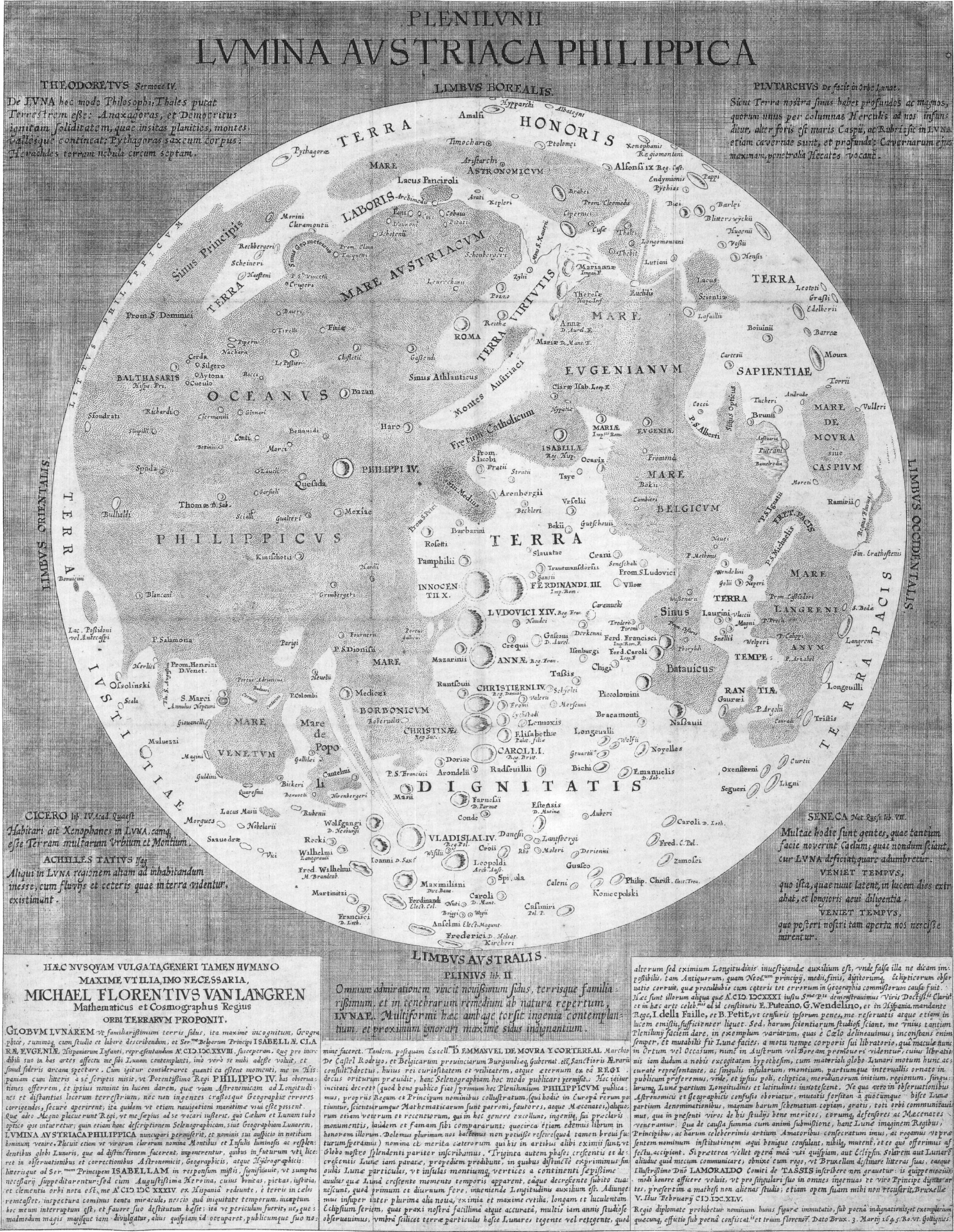
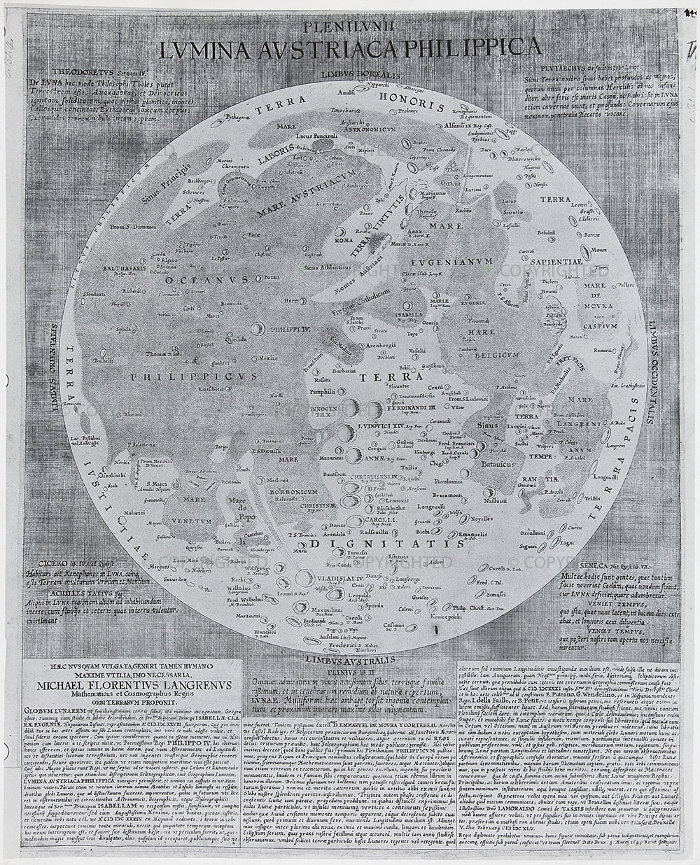
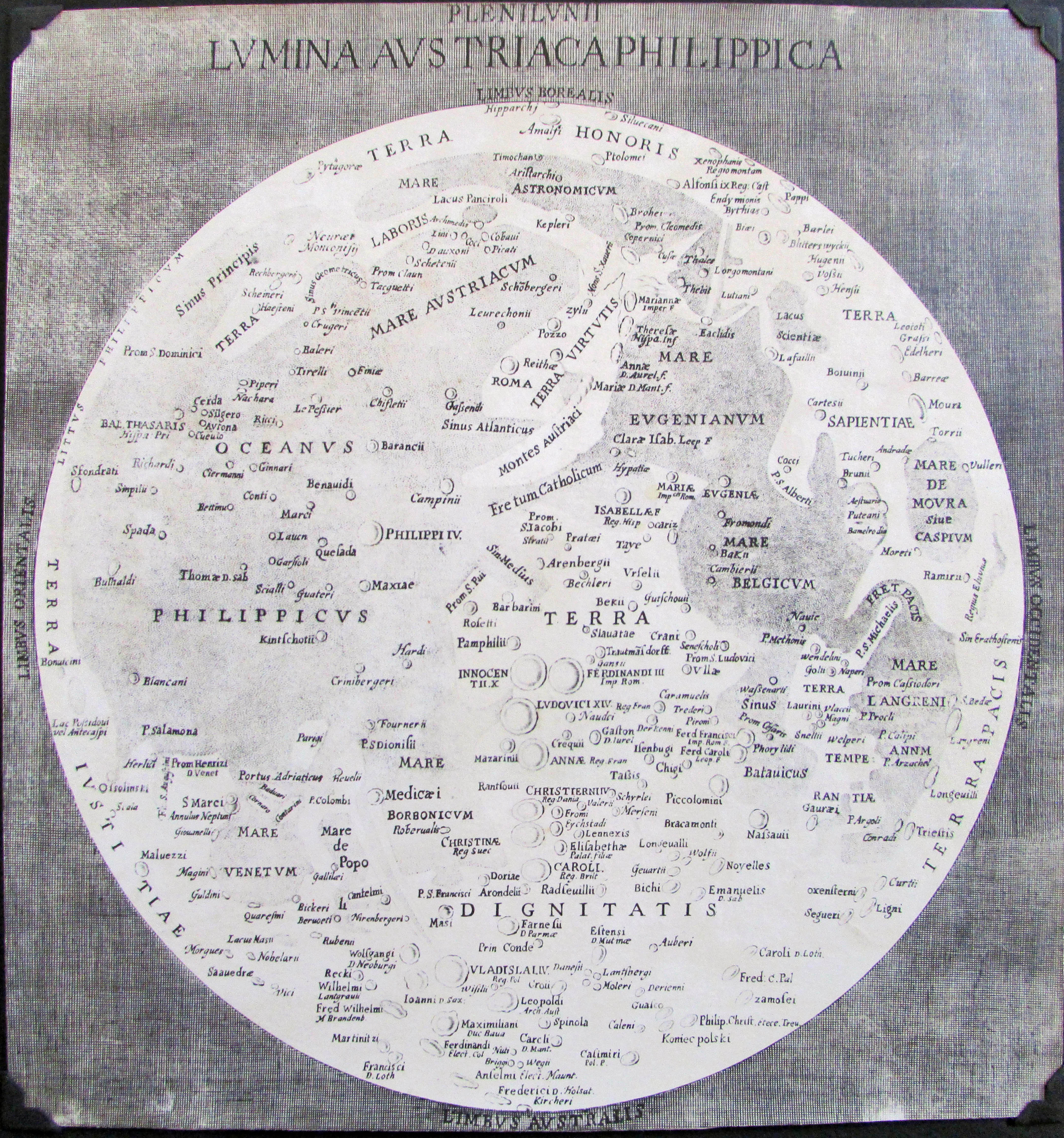
Langrenus’ map of the Moon (1645)

Publication Date: 1645
Cartographer: Michael van Langern (Langrenus)
Source: Plenilunii lumina Austriaca Philippica. [By] Michael Florentius van Langren. Copper engraving, 490 x 380 mm, diameter 340 mm. [Brussel 1645.]
Map type: Shade relief (from crescent moon observations) + albedo (from full moon observations) with nomenclature
Size: 34 cm diameter

The purpose of mapping the Moon began with a purely practical purpose: “As early as 1628, (Langren) conceived the idea of using the rotation of the moon—rather than its mere position in the sky—as a more accurate celestial clock. By timing the occurrence of sunrise or sunset on identifiable lunar peaks and craters, one would have a nearly continuous set of reference events with which local time could be accurately determined.” .. it required an accurate lunar globe or set of maps that named the peaks, craters, and other lunar features so that they could be easily recognized.

Van Langren spent a few years in the early 1630s at the court in Madrid, during which he attempted to enlist support for this project and made plans for the preparation of a collection of lunar maps and diagrams, together with a “user guide” containing instructions for the calculation of longitude from observations of the lunar features he would catalog. Because he would be the first to comprehensively map the lunar features, he proposed to have “the names of illustrious men applied to the luminous and resplendent mountains and islands of the lunar globe,” a prospect that evidently pleased King Philip”

(Source: Michael FRIENDLY, Pedro VALERO-MORA, and Joaquín IBÁÑEZ ULARGUI: The First (Known) Statistical Graph: Michael Florent van Langren and the “Secret” of Longitude. The American Statistician · May 2010)

“Van Langren’s contributions: he initiated the systematic naming of lunar
topography, he applied geographical clustering of names to the moon (areas with objects named after Frenchmen, Venetians, Dutchmen, female royalty, etc), he first used scientists to name lunar objects after, and he first used conceptual names; for land mass names he used concepts like dignity, peace, honour, virtue, work, wisdom and temperance. Finally, he adhered to a hierarchical principle by naming larger objects for more important persons.
In retrospect, he was also the first that used toponymy for propaganda, as most of the names he bestowed reflected the protagonists of the Habsburg power struggle for supremacy in seventeenth century Europe.

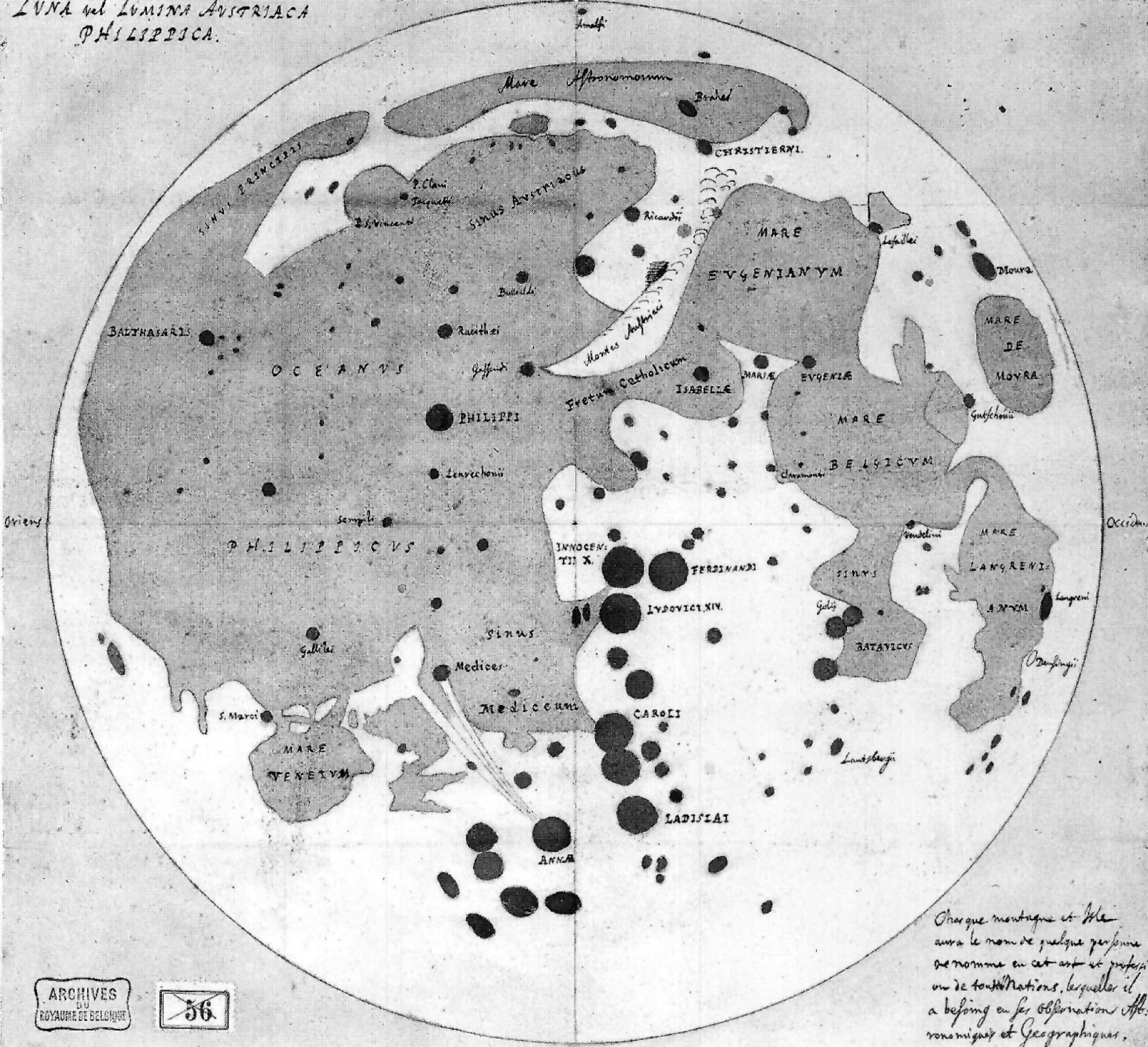
Copies of the lunar map by Van Langren can be found:
1st state: Leiden, Universiteitsbibliotheek, COLLBN 505-10-003
2nd state: Edinburgh, Royal Observatory, Crawford Library c15.6(4)
3rd state: Paris, Bibliothèque nationale, Cartes et plans GE D-17925
San Fernando, Real Instituto y Observatorio de la Armada, 17277/L-18 [bound
in John Flamsteed’s Atlas Coelestis (1729)].
4th state: Private collection”

Source:

langrenusmoon

39×50 cm, engraving in copper.
Dutch version. Leiden Universiteitsbibliotheek.

langrenus_paris

Latin version: Bibliotheque National, Paris, Crawford Library, Edinburgh, San Fernando Library of the Observatory.
Without marginal text: Bibliotheque National et Universitaire, Strassburg

langrenus

37,5×35 cm, copy of drawing, colored: terra=yellow, mare=light blue, craters=dark blue, background=light blue.
Algemee Rijksarchief, Brüssel, Karten-und Planabteilung , Inventar 7911.
Text: “Chaque montagne et isle aura le nom de quelque personne se nomme en cet art et profession de toutes Nations lesquelles il a besoin en ses observations astronomiques et geographiques.”
Resources:

langrenus-brussels

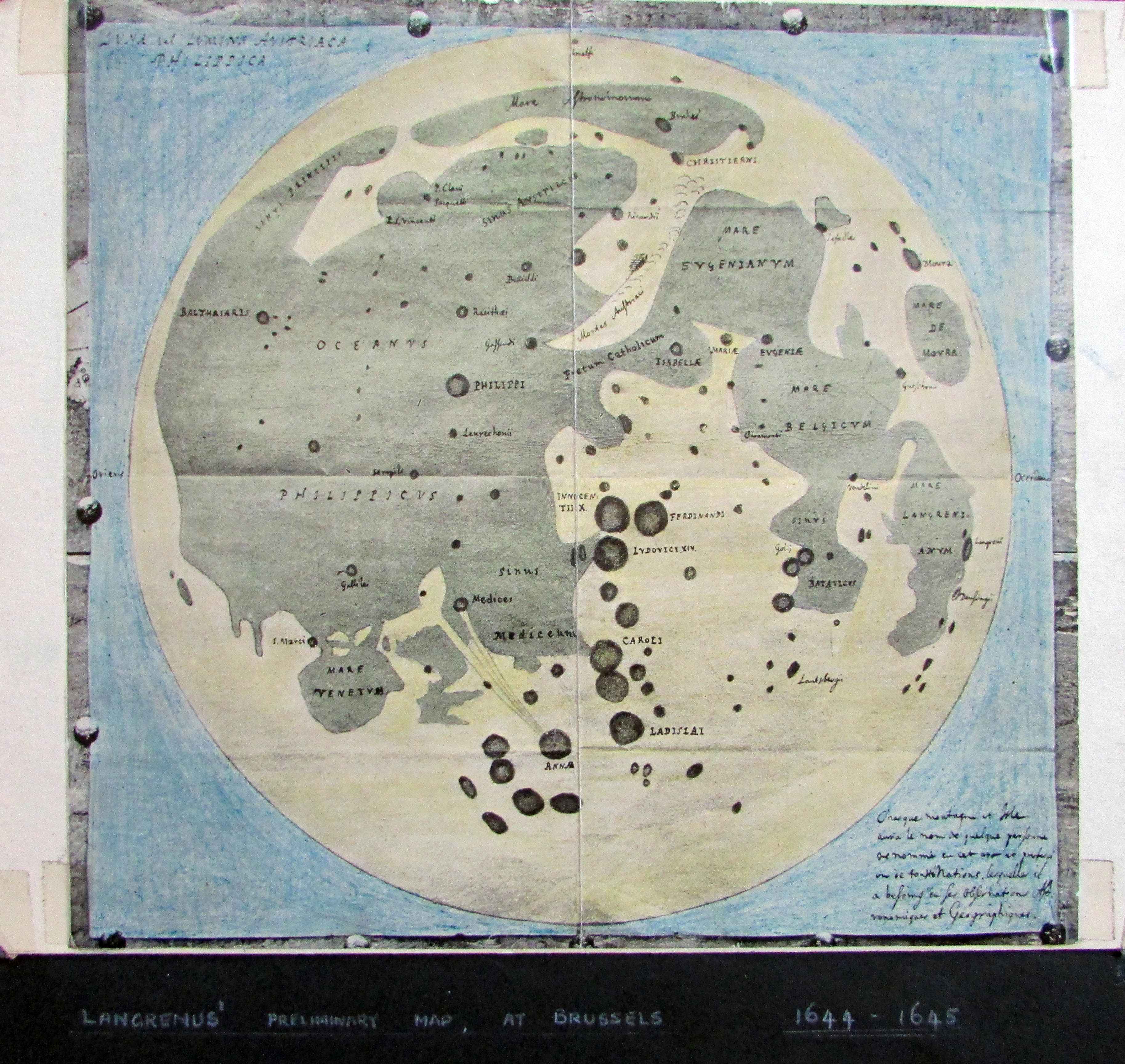
The Brussels copy, hand colored by EA Whitaker

langrenus-strassbourgcopy1645

The Strassbourg copy. Courtesy EA Whitaker. It is a “counterfeit map” copied from the original with some names mis-spelled or missing (Whitaker p. 40).

Explanation
Column name Column description
Catalog ID (M) N/A
Title Title of map
Author Name of mapper(s), or author, PI, map editor, illustrator, etc. with roles
Nationality Nationality of author
Start date Year when mapping began / or year or observation
Date of publication Year of publication or completion of manusctipt (empty if not published yet)
Body Target name (planetary body)
Online Online references about the map
Projection Projection of map. 2-hemisphere is shown here.
Scale N/A
Orientation Orientation of map [north up, south up] – only for historic maps (north: cartographic tradition, south: astronomical tradition)
Publication type The type of work that contains the map. [standalone, journal, conference, atlas, book figure, book supplement, book plate, encyclopedia, multisheet, digital]
Type, purpose Type of map purpose [generic, outreach, science, citizen, surface operation (pre mission), landing site (post mission), observer, opposition, index, reference, eclipse/transit/occultation] generic: not defined, outreach: maps for the general public made b
Primary Nomenclature Laguage(s) of nomenclature displayed on the map [Latin, English etc., IAU, informal]. Latin for Latin nomenclature prior to IAU.
Ref (map) Full reference of map publication or publication that contains the map
DOI DOI number of map
ID (publication) ID of map publication or figure number
Origin type If this map is not original, the following codes are used: [L: language variant, N: new print, U: updated edition, C: copied / modified from another map, R: renovation map (digital version of paper map with slight changes), F facsimile. RP: republished in
Origin ID Any maps that this map is based on or copied from. Database ID of original map.
Based on map Name of mapper
Base (spacecraft, telescope) Name of spacecraft / instrument
Original title Title of map in original langage (if not English)
Publisher Name of Publisher; manuscript or self-published. For journals and conferences, the name of the journal or conference.
Coverage Coverage of map [global, hemispheric, regional, local, landing site, landing ellipse, traverse]
Target location IAU name of target feature (if named) or near side, far side etc. (If nothing noted, it is global)
Country Country of Publisher (original/translation)
Type, content Type of map [photo, map, sketch map, drawing, globe, tactile, data]. Data for raster datasets. For vector data, see Feature DB. Drawing: no grid, scale, projection etc.
Image base Base theme of the map [shaded relief, photomosaic, photo, none]
Theme Theme of map [visual, albedo, radar, low sun, topography, elevation, geology, geomorphology, art, nomenclature reference, feature, landing site reference, opposition map, event (eclipse etc) etc.]. Low sun is optical photo with shadows and no albedo. Vis
Technique Cartographic technique [imagemap, datamap, cartographic map, unit map, airbrush, pencil, line drawing/outline, contour lines, DEM, DIM, shaded relief / hillshading, raster data etc.]
Style Details on style
Method Method how the data was obtained
Mapping scale Scale of mapping
Resolution Raster dataset resoltion [m/pixel]
Short Reference Short form of reference to the map publication
GIS / data URL where GIS or original spatial data is
Data provider N/A
Profession Profession of author (for historic maps)
Designator Sheet designator terms following Greeley and Batson (1990) Planetary Mapping. Cambridge University Press. – only if displayed on the map. First letter: target body, 5M: scale, 90/0 etc: center coordinates, OM – orthophotomosaic , T – Topographic data (nom
Control Controlled, semi-controlled, uncontrolled
Note on control Base of control
Series title Title of map series
Number of maps (in work) N/A
Number of quads N/A
Quad ID Quad ID (or quads IDs) contained on the map
Map Diameter N/A
Map width cm N/A
Map height cm N/A
Map width px N/A
Map height px N/A
Base type Type of instrument of observation of base data [naked eye, telescope, spacecraft, space telescope, lander]
Location of copy Library or archive where manuscript or rare copy is kept
Ref (literature) Reference – literature about the map, may be the source of data if the map is not available. Separated with # symbols.
Status (2017) Status of mapping [complete, in progress, in review] (mostly for USGS maps)
Aim Original aim of mapping, if available
Notes Any comments, remarks [Long text, may be multiple paragraphs]
Secondary nomenclature Other languages of the nomenclature
Nomenclature Notes Remarks on nomenclature
Photo note N/A
Reference frame ID from RefFrames
web2 Online references about the map
web3 Online references about the map
web4 Online references about the map
ocentric/ographic Map coordinate [planetographic, planetocentric]
N N/A
S N/A
W 360E N/A
E 360E N/A
W 180 N/A
E 180 N/A
W 360W N/A
R 360W N/A
fig1 N/A
fig1 caption N/A
fig2 N/A
fig2 caption N/A
fig3 N/A
fig3 caption N/A
fig4 N/A
fig4 caption N/A
fig5 N/A
fig5 caption N/A
STATUS N/A
Sum $180