2017 in Review 1: New Planetary Web Mapping Servers

2017 brought a boom in planetary online WMS services. We show you which new service can do what. 
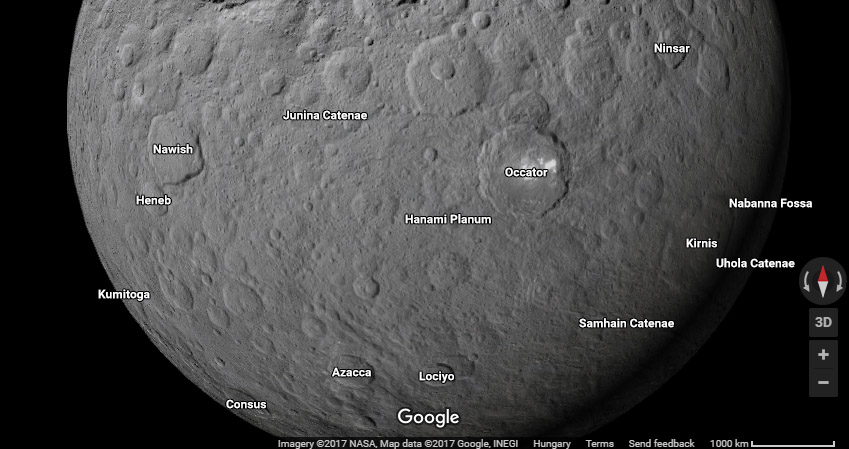
 

The new Google map

Google worked closely with NASA the next corner in Silicon Valley to prepare the highest, 5m/px resolution global photomosaic of Mars in 2012 that even researchers used for browsing Mars, only available through Google Earth, but not in the web-based map. This year Google added a wealth of new layers, although nothing is published about the image sources or cartographic control. Perhaps at LPSC2018. The service “as is” but still provides the fastest planetary image browsing opportunity for the armchair scientist. Maps include clickable nomenclature. The uniqueness of Google maps is that they are original photomosaics you can’t find elsewhere.

Some of the additions include

  • a beautiful high resolution multiscale color map of Mercury, which shows albedo at low resolution and low-sun relief view when you zoom in, both MESSENGER data
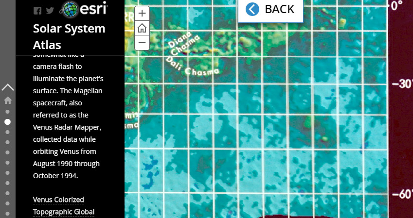
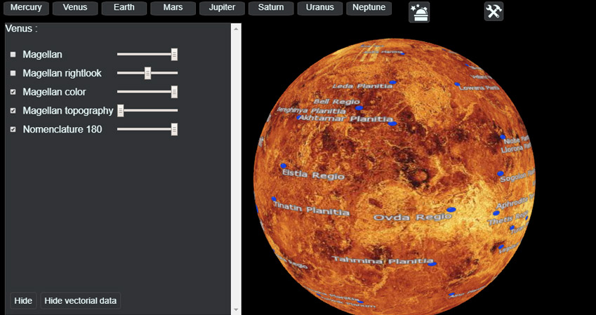
  • a global radar view of Venus at full Magellan resolution
  • a so-so albedo view of the Moon
  • Mars is now a not very seamless but quite high resolution HRSC color mosaic with some gaps
  • Ceres is added but not Vesta
  • Color and multiscale mosaic for Ganymede and Callisto
  • Titan is a nicely rendered seamless infrared+radar view at high resolution
  • Pluto and Charon is also the highest resolution global mosaic in color
  • And mosaics for other outer solar system satellites

https://www.google.com/maps/space/earth

googleceres

ESRI’s Solar System Atlas

The company behind ArcGIS, the most commonly used mapping software in planetary cartography, has published its online atlas from the layers also available for direct import into an ArcGIS project. Unlike for Google, credit is given for all image sources, but in this case mosaicking was not done by ESRI, but all maps were taken from USGS/NASA. This service is basically a tile service to quickly display existing data, including geologic maps.

http://esripm.maps.arcgis.com/apps/MapJournal/index.html?appid=f737586c543e48428b96df64057ebed0#map

esri


Planetary Surface Portal / PSUP

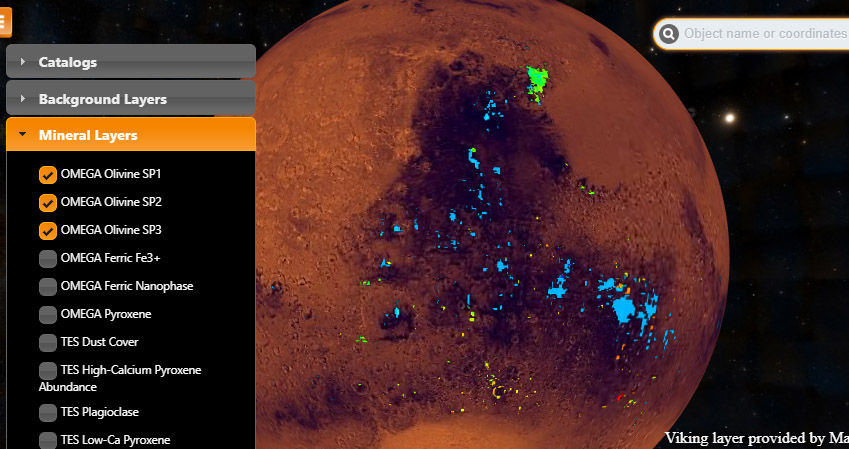
This is a service from French university observatories (Paris Sud and Lyon), who made their OMEGA data available through this service. OMEGA (Observatoire pour la Mineralogie, l’Eau, les Glaces et l’Activit) is a hyperspectral imaging spectrometer developed in France, originally for a failed Russian mission, onboard the European Mars Express spacecraft.  Mineralogial and albedo data can be viewed, and downloaded from the WMS along with some feature database layers.

http://psup.ias.u-psud.fr/sitools/client-user/index.html?project=PLISonMars

psup

Planetary Cesium Viewer

The Cesium technology based viewer from the Paris Sud University in France shows global mosaics for basically all major moons and planets in the Solar System, including the gas giants.  The maps can be viewed as globes or 2D flat maps. The code is open, and available on Github.

http://134.158.75.177

planetarycesium


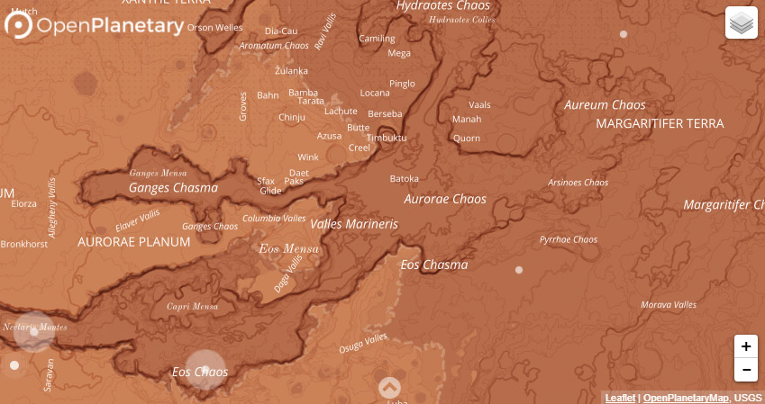
Open Planetary Map Mars Basemap v0.1

The Open Planetary project aims to develop a vector based Mars map that users can modify and personalize. This is a community-based project where planetary scientists can share their cartographic ideas. The map using CARTO Builder and there are detailed instructions on how you can build your own map within this system. This is the first attempt to create a vector-based Mars basemap, which would bring fresh air into a raster-filled planetary mapping universe.

http://openplanetary.co/opm/#3/11.80/-45.04
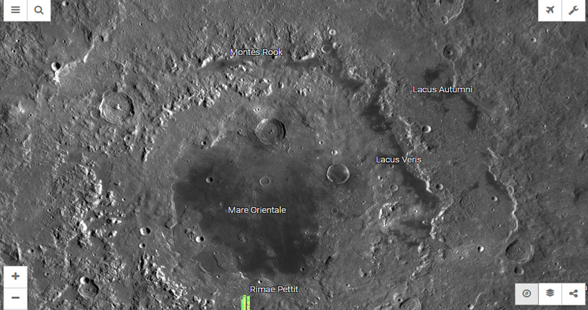
openplanetary

Moon Trek

The official NASA outreach/research map combo for the Moon, an online platform  for both enthusiasts and researchers. Numerous datasets, mapping and analysis tools are offered. Developed at NASA Ames and JPL in California.

https://moontrek.jpl.nasa.gov

moontrek

And we did not list those WMS services that started before 2017…


Which one is your favorite? Vote for the best new planetary WMS in 2017:


Explanation
Column name Column description
Catalog ID (M) N/A
Title Title of map
Author Name of mapper(s), or author, PI, map editor, illustrator, etc. with roles
Nationality Nationality of author
Start date Year when mapping began / or year or observation
Date of publication Year of publication or completion of manusctipt (empty if not published yet)
Body Target name (planetary body)
Online Online references about the map
Projection Projection of map. 2-hemisphere is shown here.
Scale N/A
Orientation Orientation of map [north up, south up] – only for historic maps (north: cartographic tradition, south: astronomical tradition)
Publication type The type of work that contains the map. [standalone, journal, conference, atlas, book figure, book supplement, book plate, encyclopedia, multisheet, digital]
Type, purpose Type of map purpose [generic, outreach, science, citizen, surface operation (pre mission), landing site (post mission), observer, opposition, index, reference, eclipse/transit/occultation] generic: not defined, outreach: maps for the general public made b
Primary Nomenclature Laguage(s) of nomenclature displayed on the map [Latin, English etc., IAU, informal]. Latin for Latin nomenclature prior to IAU.
Ref (map) Full reference of map publication or publication that contains the map
DOI DOI number of map
ID (publication) ID of map publication or figure number
Origin type If this map is not original, the following codes are used: [L: language variant, N: new print, U: updated edition, C: copied / modified from another map, R: renovation map (digital version of paper map with slight changes), F facsimile. RP: republished in
Origin ID Any maps that this map is based on or copied from. Database ID of original map.
Based on map Name of mapper
Base (spacecraft, telescope) Name of spacecraft / instrument
Original title Title of map in original langage (if not English)
Publisher Name of Publisher; manuscript or self-published. For journals and conferences, the name of the journal or conference.
Coverage Coverage of map [global, hemispheric, regional, local, landing site, landing ellipse, traverse]
Target location IAU name of target feature (if named) or near side, far side etc. (If nothing noted, it is global)
Country Country of Publisher (original/translation)
Type, content Type of map [photo, map, sketch map, drawing, globe, tactile, data]. Data for raster datasets. For vector data, see Feature DB. Drawing: no grid, scale, projection etc.
Image base Base theme of the map [shaded relief, photomosaic, photo, none]
Theme Theme of map [visual, albedo, radar, low sun, topography, elevation, geology, geomorphology, art, nomenclature reference, feature, landing site reference, opposition map, event (eclipse etc) etc.]. Low sun is optical photo with shadows and no albedo. Vis
Technique Cartographic technique [imagemap, datamap, cartographic map, unit map, airbrush, pencil, line drawing/outline, contour lines, DEM, DIM, shaded relief / hillshading, raster data etc.]
Style Details on style
Method Method how the data was obtained
Mapping scale Scale of mapping
Resolution Raster dataset resoltion [m/pixel]
Short Reference Short form of reference to the map publication
GIS / data URL where GIS or original spatial data is
Data provider N/A
Profession Profession of author (for historic maps)
Designator Sheet designator terms following Greeley and Batson (1990) Planetary Mapping. Cambridge University Press. – only if displayed on the map. First letter: target body, 5M: scale, 90/0 etc: center coordinates, OM – orthophotomosaic , T – Topographic data (nom
Control Controlled, semi-controlled, uncontrolled
Note on control Base of control
Series title Title of map series
Number of maps (in work) N/A
Number of quads N/A
Quad ID Quad ID (or quads IDs) contained on the map
Map Diameter N/A
Map width cm N/A
Map height cm N/A
Map width px N/A
Map height px N/A
Base type Type of instrument of observation of base data [naked eye, telescope, spacecraft, space telescope, lander]
Location of copy Library or archive where manuscript or rare copy is kept
Ref (literature) Reference – literature about the map, may be the source of data if the map is not available. Separated with # symbols.
Status (2017) Status of mapping [complete, in progress, in review] (mostly for USGS maps)
Aim Original aim of mapping, if available
Notes Any comments, remarks [Long text, may be multiple paragraphs]
Secondary nomenclature Other languages of the nomenclature
Nomenclature Notes Remarks on nomenclature
Photo note N/A
Reference frame ID from RefFrames
web2 Online references about the map
web3 Online references about the map
web4 Online references about the map
ocentric/ographic Map coordinate [planetographic, planetocentric]
N N/A
S N/A
W 360E N/A
E 360E N/A
W 180 N/A
E 180 N/A
W 360W N/A
R 360W N/A
fig1 N/A
fig1 caption N/A
fig2 N/A
fig2 caption N/A
fig3 N/A
fig3 caption N/A
fig4 N/A
fig4 caption N/A
fig5 N/A
fig5 caption N/A
STATUS N/A
Sum $180