Photomap

Mappa di Marte

Mappa di Marte

The map of Mars / Mars wall map Mappa di Marte / Geoposter Marte Standalone Geo4map Srl – Novara, Libreria Geografica Outreach map Visual Photomosaic? 2017 ISBN 978-8869851766 IAU nomenclature Explanatory text in Italian

Venera Landing Site Maps 1976-83

Venera Landing Site Maps 1976-83

Publisher: ЦНИИГАИК Топосхемы 1976: 1:50 (Venera 9 site) ПЛАН 1980: 1:10 (Venera 9 site) Фотоплан 1983, 1:20 (Venera 10 site) Image source: Atlas of Terrestrial planets and their moons, MIiGAIK, 1992.

Rand McNally’s Official Maps of the Moon (1958-)

Rand McNally’s Official Maps of the Moon (1958-)

The 1958 edition includes the Physiographic division of the Moon that was published only in 1961. Background: ACIC. 1958 edition, printed in Japan 1969 edition Far side of the Moon: M 1:5.5M. Shaded relief aibrush map, based on Lunar Orbiter I-V images.  1969 Apollo landing sites 1969

Hammond Moon Charts (1966/69)

Hammond Moon Charts (1966/69)

CS. Hammond and CO., 1966 and 1969 Background photo from ACIC Encyclopedia of Aviation and Space Sciences Map 49 x 71 cm. Courtesy Ton Lindeman

Controlled Color Mosaic Mars series (DRL)

Scale: 1:700k Date: 2016 MC-11E quadrangle. This mapping effort supports ExoMars landing site selection Source: Katja Schulz: Topographische Karten der Mars-Region MC-11-E ‒ erstellt auf Basis eines HRSC-Orthofotomosaiks der Mission Mars Express, AGIT – Journal für Angewandte Geoinformatik, 3-2017. Image: HRSC (ESA/DLR/FU Berlin, CC BY-SA 3.0 IGO)  

Phobos Atlas (DLR) (2008)

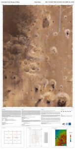
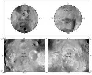
Controlled Mosaic of Phobos 4 Quads Editors: Oberst, J, DLR. Photogrammetry: Oberst J, Willner K., Cartography: Semm S, Wahlisch M References: Konrad Willner: The Martian Moon Phobos A Geodetic Analysis of its Motion, Orientation, Shape, and Physical Parameters. Berlin 2009 M.Wählisch et al 2010  A new topographic image atlas of Phobos

Mariner 9 Photomosaic Globe of Mars

Mariner 9 Photomosaic Globe of Mars

Mosaic made of 1500 Mariner 9 images. This is one of three globes each made manually. Size: 48in. (121.9cm) Date 1973 Material: paper photos on aluminum 6-foot copy: Displayed in  von Karman auditorium of the JPL campus in Pasadena, 4-foot copies:  On Display at the Smithsonian Museum, Washington, DC (2017), California and Lewis Research Center in Cleveland, Ohio. […]

The Moon through the eyepiece

The Moon through the eyepiece

Aero-Space Laboratories, Missile Division, North American Aviation Inc. Map provided courtesy of the USGS Flagstaff Library.

Photomap of the visible side of the Moon (1967)

Photomap of the visible side of the Moon (1967)

Фотокарта видимого полушария.СССР, Ю. Н. Липский, М., «Наука», 1967. Fotokarta Vidimogo Polusariya Luny Nauka, Moskva, 1967. 1:5 000 000 Yu. N. Lipskiy Sternberg State Astronomical Institute „Gerard Kuiper took two Lick Observatory photographs to Moscow, where a group of military cartographers workig under Lev Bugaevsky combined them with other images to create this photomap. Professor Yurii […]

Persian Lunar Photomaps (2005)

Persian Lunar Photomaps (2005)

  This map (photo) is by Ardakani (Ardekani), Hossein Haeri (2005) This  map are available on the Persian Wikipedia and is a translation of the English version (to the right)  

Lyot’s Maps of the Galilean Satellites and Titan (1941/61)

Lyot’s Maps of the Galilean Satellites and Titan (1941/61)

Albedo maps of the Galilean satellites. Lyot examined these satellites with the 38 cm refractor in 1941, later with the 60-cm telescope. Markings confirmed by Camichel and Gentili. Source: A. Dollfus: Visual and photographic studies off planets at the Pic du Midi. In: Planets and Satellites, GP Kuiper and B Middlehurst, eds. Chicago Univ Press […]

Explanation
Column name Column description
Catalog ID (M) N/A
Title Title of map
Author Name of mapper(s), or author, PI, map editor, illustrator, etc. with roles
Nationality Nationality of author
Start date Year when mapping began / or year or observation
Date of publication Year of publication or completion of manusctipt (empty if not published yet)
Body Target name (planetary body)
Online Online references about the map
Projection Projection of map. 2-hemisphere is shown here.
Scale N/A
Orientation Orientation of map [north up, south up] – only for historic maps (north: cartographic tradition, south: astronomical tradition)
Publication type The type of work that contains the map. [standalone, journal, conference, atlas, book figure, book supplement, book plate, encyclopedia, multisheet, digital]
Type, purpose Type of map purpose [generic, outreach, science, citizen, surface operation (pre mission), landing site (post mission), observer, opposition, index, reference, eclipse/transit/occultation] generic: not defined, outreach: maps for the general public made b
Primary Nomenclature Laguage(s) of nomenclature displayed on the map [Latin, English etc., IAU, informal]. Latin for Latin nomenclature prior to IAU.
Ref (map) Full reference of map publication or publication that contains the map
DOI DOI number of map
ID (publication) ID of map publication or figure number
Origin type If this map is not original, the following codes are used: [L: language variant, N: new print, U: updated edition, C: copied / modified from another map, R: renovation map (digital version of paper map with slight changes), F facsimile. RP: republished in
Origin ID Any maps that this map is based on or copied from. Database ID of original map.
Based on map Name of mapper
Base (spacecraft, telescope) Name of spacecraft / instrument
Original title Title of map in original langage (if not English)
Publisher Name of Publisher; manuscript or self-published. For journals and conferences, the name of the journal or conference.
Coverage Coverage of map [global, hemispheric, regional, local, landing site, landing ellipse, traverse]
Target location IAU name of target feature (if named) or near side, far side etc. (If nothing noted, it is global)
Country Country of Publisher (original/translation)
Type, content Type of map [photo, map, sketch map, drawing, globe, tactile, data]. Data for raster datasets. For vector data, see Feature DB. Drawing: no grid, scale, projection etc.
Image base Base theme of the map [shaded relief, photomosaic, photo, none]
Theme Theme of map [visual, albedo, radar, low sun, topography, elevation, geology, geomorphology, art, nomenclature reference, feature, landing site reference, opposition map, event (eclipse etc) etc.]. Low sun is optical photo with shadows and no albedo. Vis
Technique Cartographic technique [imagemap, datamap, cartographic map, unit map, airbrush, pencil, line drawing/outline, contour lines, DEM, DIM, shaded relief / hillshading, raster data etc.]
Style Details on style
Method Method how the data was obtained
Mapping scale Scale of mapping
Resolution Raster dataset resoltion [m/pixel]
Short Reference Short form of reference to the map publication
GIS / data URL where GIS or original spatial data is
Data provider N/A
Profession Profession of author (for historic maps)
Designator Sheet designator terms following Greeley and Batson (1990) Planetary Mapping. Cambridge University Press. – only if displayed on the map. First letter: target body, 5M: scale, 90/0 etc: center coordinates, OM – orthophotomosaic , T – Topographic data (nom
Control Controlled, semi-controlled, uncontrolled
Note on control Base of control
Series title Title of map series
Number of maps (in work) N/A
Number of quads N/A
Quad ID Quad ID (or quads IDs) contained on the map
Map Diameter N/A
Map width cm N/A
Map height cm N/A
Map width px N/A
Map height px N/A
Base type Type of instrument of observation of base data [naked eye, telescope, spacecraft, space telescope, lander]
Location of copy Library or archive where manuscript or rare copy is kept
Ref (literature) Reference – literature about the map, may be the source of data if the map is not available. Separated with # symbols.
Status (2017) Status of mapping [complete, in progress, in review] (mostly for USGS maps)
Aim Original aim of mapping, if available
Notes Any comments, remarks [Long text, may be multiple paragraphs]
Secondary nomenclature Other languages of the nomenclature
Nomenclature Notes Remarks on nomenclature
Photo note N/A
Reference frame ID from RefFrames
web2 Online references about the map
web3 Online references about the map
web4 Online references about the map
ocentric/ographic Map coordinate [planetographic, planetocentric]
N N/A
S N/A
W 360E N/A
E 360E N/A
W 180 N/A
E 180 N/A
W 360W N/A
R 360W N/A
fig1 N/A
fig1 caption N/A
fig2 N/A
fig2 caption N/A
fig3 N/A
fig3 caption N/A
fig4 N/A
fig4 caption N/A
fig5 N/A
fig5 caption N/A
STATUS N/A
Sum $180