Geologic map

Sketch map of terrains on Enceladus

Smith BA et al. 1982 A New Look at the Saturn System: The Voyager 2 Images, Science , Jan. 29, 1982, New Series, Vol. 215, No. 4532 (Jan. 29, 1982), pp. 504-537

Geologic terrain map of Mercury (1975)

Geologic terrain map of Mercury (1975)

The first geologic map of Mercury Trask NJ, Guest JE 1975 Preliminary Geologic Terrain Map of Mercury. Journal of Geopgys. Res. 80 17 2461-, 2 maps on color plate 1a, 1b

The first geologic map of Io

The first geologic map of Io

In: David Morrison, Mildred Shapley Matthews, eds, 1982. Satellites of Jupiter p 943, Color section of, Plate 7.

The first geologic map of Europa

The first geologic map of Europa

In: David Morrison, Mildred Shapley Matthews, eds, 1982. Satellites of Jupiter p 941, Color section of, Plate 5

The first Geologic map of Ganymede

The first Geologic map of Ganymede

Geologic map of Ganymede. In: David Morrison, Mildred Shapley Matthews, eds, 1982. Satellites of Jupiter p938-939, Color section of, Plates 2-3,H.M. Ferguson, B.K. Lucchitta, S. W. Squyres, and D. E. Wilhelms 1:42M

Generalized geologic map of the region West of Tharsis Montes

Generalized geologic map of the region West of Tharsis Montes

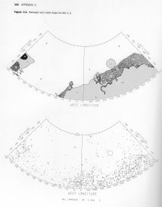
Marte Vallis first appears on this map. This paper is not subject to U.S. copyright. Published in 1982 by the American Geophysical Union. David H. Scott, Kenneth L. Tanaka 1982 Ignimbrites of Amazonis Planitia Region of Mars. Journal of Geophys. Res. Solid Earth https://doi.org/10.1029/JB087iB02p01179

The First Geologic Sketch Maps of the Equatorial Region of Mars (1972)

The First Geologic Sketch Maps of the Equatorial Region of Mars (1972)

“The rationale and methods employed in the mapping were similar to those used for the Moon as described by Wilhelms and McCauley (1971) and McCauley and Wilhelms (1971)” McCAULEY,J. F., ANDWILHELMS,D. E. (1971). Geological provinces of the near side of the Moon. Icarus 15, 363 WILHELMS, D. E., AND McCAuLEY, J. F. (1971). Geologic map […]

Unified Geologic Map of the Moon, 1:5M (2020)

Unified Geologic Map of the Moon, 1:5M (2020)

Original comment: “This new work represents a seamless, globally consistent, 1:5,000,000-scale geologic map derived from the six digitally renovated geologic maps … The product overlies shaded-relief products derived from SELENE Kaguya terrain camera stereo (equatorial, ~60 m/pix) and LOLA altimetry (north and south polar, 100 m/pix).” Source: https://astrogeology.usgs.gov/search/map/Moon/Geology/Unified_Geologic_Map_of_the_Moon_GIS GIS is included in the original release. […]

Generalized Photogeologic Map of the Moon (1961)

Generalized Photogeologic Map of the Moon (1961)

Hackman, Robert J. (research and compilation) Modified 1961 Engineer Special Study of the Surface of the Moon Greyscale units, linework 1:9M (approx), originally compiled at 1:3.8M Prepared for the Office of the Chief of Engineers by the U.S. Geological Survey, as part of a joint program with the Army Map Service Source: AC Mason, RJ […]

Map of the Volcanic Forms of the Moon (1974)

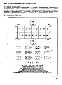
Source: Academy of Sciences of the USSR, Order of the Red Banner of Labour Geological Institute: Volcanism and Tectonics of the Mon. Nauka, Moscow 1974. Editors: AV Peive, VV Menner, VG Gerbova, PP Tomofeev, MS Markov. Карта вулкавических форм Луны А – схема расnоложенuя лuстов карты 1 – кратеры вулканичесного происхождения; 2 – нратеры предположитепьио […]

Crater maps of Mars 1976

Geologic and crater sketch maps of Mars, all quadrangles. In: Mutch et al. The Geology of Mars. 1976

Geomorphological Map of Mars

Geomorphological Map of Mars

1:20M Moscow 1978-1981 Ministry of Geology of the USSR All Union Scientific Research Institute of Geology of Foreign Countries Vniizarubezhegeologia Ministry of Higher and Secondary Special Education of the USSR Moscow State University named after M.V.Lomonosov, Geological Faculty Compiled by: NV Makarova, YaG Kats, VV Kozlov, ED Soulidi-Kondratiev, VL Avdeyev, AM Nikishin, TP Onufriyuk, GM […]

Explanation
Column name Column description
Catalog ID (M) N/A
Title Title of map
Author Name of mapper(s), or author, PI, map editor, illustrator, etc. with roles
Nationality Nationality of author
Start date Year when mapping began / or year or observation
Date of publication Year of publication or completion of manusctipt (empty if not published yet)
Body Target name (planetary body)
Online Online references about the map
Projection Projection of map. 2-hemisphere is shown here.
Scale N/A
Orientation Orientation of map [north up, south up] – only for historic maps (north: cartographic tradition, south: astronomical tradition)
Publication type The type of work that contains the map. [standalone, journal, conference, atlas, book figure, book supplement, book plate, encyclopedia, multisheet, digital]
Type, purpose Type of map purpose [generic, outreach, science, citizen, surface operation (pre mission), landing site (post mission), observer, opposition, index, reference, eclipse/transit/occultation] generic: not defined, outreach: maps for the general public made b
Primary Nomenclature Laguage(s) of nomenclature displayed on the map [Latin, English etc., IAU, informal]. Latin for Latin nomenclature prior to IAU.
Ref (map) Full reference of map publication or publication that contains the map
DOI DOI number of map
ID (publication) ID of map publication or figure number
Origin type If this map is not original, the following codes are used: [L: language variant, N: new print, U: updated edition, C: copied / modified from another map, R: renovation map (digital version of paper map with slight changes), F facsimile. RP: republished in
Origin ID Any maps that this map is based on or copied from. Database ID of original map.
Based on map Name of mapper
Base (spacecraft, telescope) Name of spacecraft / instrument
Original title Title of map in original langage (if not English)
Publisher Name of Publisher; manuscript or self-published. For journals and conferences, the name of the journal or conference.
Coverage Coverage of map [global, hemispheric, regional, local, landing site, landing ellipse, traverse]
Target location IAU name of target feature (if named) or near side, far side etc. (If nothing noted, it is global)
Country Country of Publisher (original/translation)
Type, content Type of map [photo, map, sketch map, drawing, globe, tactile, data]. Data for raster datasets. For vector data, see Feature DB. Drawing: no grid, scale, projection etc.
Image base Base theme of the map [shaded relief, photomosaic, photo, none]
Theme Theme of map [visual, albedo, radar, low sun, topography, elevation, geology, geomorphology, art, nomenclature reference, feature, landing site reference, opposition map, event (eclipse etc) etc.]. Low sun is optical photo with shadows and no albedo. Vis
Technique Cartographic technique [imagemap, datamap, cartographic map, unit map, airbrush, pencil, line drawing/outline, contour lines, DEM, DIM, shaded relief / hillshading, raster data etc.]
Style Details on style
Method Method how the data was obtained
Mapping scale Scale of mapping
Resolution Raster dataset resoltion [m/pixel]
Short Reference Short form of reference to the map publication
GIS / data URL where GIS or original spatial data is
Data provider N/A
Profession Profession of author (for historic maps)
Designator Sheet designator terms following Greeley and Batson (1990) Planetary Mapping. Cambridge University Press. – only if displayed on the map. First letter: target body, 5M: scale, 90/0 etc: center coordinates, OM – orthophotomosaic , T – Topographic data (nom
Control Controlled, semi-controlled, uncontrolled
Note on control Base of control
Series title Title of map series
Number of maps (in work) N/A
Number of quads N/A
Quad ID Quad ID (or quads IDs) contained on the map
Map Diameter N/A
Map width cm N/A
Map height cm N/A
Map width px N/A
Map height px N/A
Base type Type of instrument of observation of base data [naked eye, telescope, spacecraft, space telescope, lander]
Location of copy Library or archive where manuscript or rare copy is kept
Ref (literature) Reference – literature about the map, may be the source of data if the map is not available. Separated with # symbols.
Status (2017) Status of mapping [complete, in progress, in review] (mostly for USGS maps)
Aim Original aim of mapping, if available
Notes Any comments, remarks [Long text, may be multiple paragraphs]
Secondary nomenclature Other languages of the nomenclature
Nomenclature Notes Remarks on nomenclature
Photo note N/A
Reference frame ID from RefFrames
web2 Online references about the map
web3 Online references about the map
web4 Online references about the map
ocentric/ographic Map coordinate [planetographic, planetocentric]
N N/A
S N/A
W 360E N/A
E 360E N/A
W 180 N/A
E 180 N/A
W 360W N/A
R 360W N/A
fig1 N/A
fig1 caption N/A
fig2 N/A
fig2 caption N/A
fig3 N/A
fig3 caption N/A
fig4 N/A
fig4 caption N/A
fig5 N/A
fig5 caption N/A
STATUS N/A
Sum $180