Thematic map

Mars compared to France map (Antoniadi 1930)

Mars compared to France map (Antoniadi 1930)

Antoniadi 1930 La Planete Mars. Etude basee sur les resultats obtenus avec la grande lunette de l’Observatoire de Meudon et expose analytique de l’ensemble des travaux executes sur cet astre depuis 1659. Paris: Hermann & Cie, 1930

Dollfus’ Mars Polar Cap Map 1956

Dollfus’ Mars Polar Cap Map 1956

The two extremes of the south polar cap of Mars in 1956. (Pic du Midi, Dollfus). In: Dollfus, A. 1965  Étude de la planète Mars de 1954 à 1958 Annales d’Astrophysique, Vol. 28, p.722

Antoniadi’s Polar Maps of Mars 1900-1901

Antoniadi’s Polar Maps of Mars 1900-1901

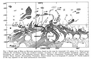
Antoniadi EM, Attkins EAL, Bolton S, Buchanan WE, Corder H, Craig SR, Hall WJ, Kibbler WA, Killip R? Molesworth PB, Phillips TER, Price WS, Smith HF, Townshend HJ 1903 Mars – Report of the Section, 1900-1901. Memoirs of the British Astronomical Association, Volume 11, p7513 (167-, 86-) LONDON Chart on the North Polar regions of […]

McLaughlin’s wind map of Mars (1954)

  Source McLaughlin, D. B.: Wind patterns and volcanoes on Mars. The Observatory, Vol. 74, p. 166-168 (1954) McLaughlin, D. B.: Interpretation of Some Martian Features. Publications of the Astronomical Society of the Pacific, Vol. 66, No. 391, p.161

Housden’s maps and infographics of Mars hydrology (1914)

Housden’s maps and infographics of Mars hydrology (1914)

Housden CE 1914 The riddle of Mars the planet. Longmans, Green and Co. London, New York, Bombay, Calcutta

Vegetation map of Mars and Earth (sprouting times on Mars)

Vegetation map of Mars and Earth (sprouting times on Mars)

Lowell, P 1908 Mars as the abode of life. Macmillan, New York

Temperature map of the Moon

Temperature map of the Moon

Source: Zerinváry Szilárd: A Naprendszer élete. Művelt Nép Könyvkiadó, 1953, Budapest Origin of the map unknown. Caption: Temperature values on the Moon in the Sun-facing hemisphere.    

Lukács’s Copy of Lowell’s Map of the Polar cap of Mars (1904)

Lukács’s Copy of Lowell’s Map of the Polar cap of Mars (1904)

A Mars és a Föld összehasonlító topográfiája. Comparative topography of Mars and Earth. Lukács Károly 1904. Manuscript. Pencil and ink A copy of another map, with signature “R de M” (?) Lukács Károly: A sarki hósüvegek változásai a Marson és a Földön. Földrajzi Közlemények 1904. február, 11. füzet. 41-72   Original: Map of the South Pole […]

Map of Mars showing channels and possible paleolake basins (1995)

Map of Mars showing channels and possible paleolake basins (1995)

(Detail) D.H. Scott, J.M. Dohm, and J. W. Rice Jr. 1995  Map of Mars showing channels and possible paleolake basins. IMAP 2461. USGS. https://pubs.er.usgs.gov/publication/i2461

Strom’s Lineament Maps of the Moon (1964)

Strom’s Lineament Maps of the Moon (1964)

Author: Robert G. Strom Drawn by T.E.Weller Date: 1964 Tectonic Map of the Moon, Maps of the Lunar Lineament Systems Orthographic Projection, 1:5.7M      

Geomorphological Map of Mars

Geomorphological Map of Mars

1:20M Moscow 1978-1981 Ministry of Geology of the USSR All Union Scientific Research Institute of Geology of Foreign Countries Vniizarubezhegeologia Ministry of Higher and Secondary Special Education of the USSR Moscow State University named after M.V.Lomonosov, Geological Faculty Compiled by: NV Makarova, YaG Kats, VV Kozlov, ED Soulidi-Kondratiev, VL Avdeyev, AM Nikishin, TP Onufriyuk, GM […]

Geomorphological map of Mars, Melas Chasma

Geomorphological map of Mars, Melas Chasma

M 1:500k JP Pleuvast Laboratorie de Geographie Physique, ATP de Planetologie INSU, Meudon, France Graphics: V Lahaye-Boquet, Paris IV 1991 Map provided courtesy of the USGS Flagstaff Library.  

Explanation
Column name Column description
Catalog ID (M) N/A
Title Title of map
Author Name of mapper(s), or author, PI, map editor, illustrator, etc. with roles
Nationality Nationality of author
Start date Year when mapping began / or year or observation
Date of publication Year of publication or completion of manusctipt (empty if not published yet)
Body Target name (planetary body)
Online Online references about the map
Projection Projection of map. 2-hemisphere is shown here.
Scale N/A
Orientation Orientation of map [north up, south up] – only for historic maps (north: cartographic tradition, south: astronomical tradition)
Publication type The type of work that contains the map. [standalone, journal, conference, atlas, book figure, book supplement, book plate, encyclopedia, multisheet, digital]
Type, purpose Type of map purpose [generic, outreach, science, citizen, surface operation (pre mission), landing site (post mission), observer, opposition, index, reference, eclipse/transit/occultation] generic: not defined, outreach: maps for the general public made b
Primary Nomenclature Laguage(s) of nomenclature displayed on the map [Latin, English etc., IAU, informal]. Latin for Latin nomenclature prior to IAU.
Ref (map) Full reference of map publication or publication that contains the map
DOI DOI number of map
ID (publication) ID of map publication or figure number
Origin type If this map is not original, the following codes are used: [L: language variant, N: new print, U: updated edition, C: copied / modified from another map, R: renovation map (digital version of paper map with slight changes), F facsimile. RP: republished in
Origin ID Any maps that this map is based on or copied from. Database ID of original map.
Based on map Name of mapper
Base (spacecraft, telescope) Name of spacecraft / instrument
Original title Title of map in original langage (if not English)
Publisher Name of Publisher; manuscript or self-published. For journals and conferences, the name of the journal or conference.
Coverage Coverage of map [global, hemispheric, regional, local, landing site, landing ellipse, traverse]
Target location IAU name of target feature (if named) or near side, far side etc. (If nothing noted, it is global)
Country Country of Publisher (original/translation)
Type, content Type of map [photo, map, sketch map, drawing, globe, tactile, data]. Data for raster datasets. For vector data, see Feature DB. Drawing: no grid, scale, projection etc.
Image base Base theme of the map [shaded relief, photomosaic, photo, none]
Theme Theme of map [visual, albedo, radar, low sun, topography, elevation, geology, geomorphology, art, nomenclature reference, feature, landing site reference, opposition map, event (eclipse etc) etc.]. Low sun is optical photo with shadows and no albedo. Vis
Technique Cartographic technique [imagemap, datamap, cartographic map, unit map, airbrush, pencil, line drawing/outline, contour lines, DEM, DIM, shaded relief / hillshading, raster data etc.]
Style Details on style
Method Method how the data was obtained
Mapping scale Scale of mapping
Resolution Raster dataset resoltion [m/pixel]
Short Reference Short form of reference to the map publication
GIS / data URL where GIS or original spatial data is
Data provider N/A
Profession Profession of author (for historic maps)
Designator Sheet designator terms following Greeley and Batson (1990) Planetary Mapping. Cambridge University Press. – only if displayed on the map. First letter: target body, 5M: scale, 90/0 etc: center coordinates, OM – orthophotomosaic , T – Topographic data (nom
Control Controlled, semi-controlled, uncontrolled
Note on control Base of control
Series title Title of map series
Number of maps (in work) N/A
Number of quads N/A
Quad ID Quad ID (or quads IDs) contained on the map
Map Diameter N/A
Map width cm N/A
Map height cm N/A
Map width px N/A
Map height px N/A
Base type Type of instrument of observation of base data [naked eye, telescope, spacecraft, space telescope, lander]
Location of copy Library or archive where manuscript or rare copy is kept
Ref (literature) Reference – literature about the map, may be the source of data if the map is not available. Separated with # symbols.
Status (2017) Status of mapping [complete, in progress, in review] (mostly for USGS maps)
Aim Original aim of mapping, if available
Notes Any comments, remarks [Long text, may be multiple paragraphs]
Secondary nomenclature Other languages of the nomenclature
Nomenclature Notes Remarks on nomenclature
Photo note N/A
Reference frame ID from RefFrames
web2 Online references about the map
web3 Online references about the map
web4 Online references about the map
ocentric/ographic Map coordinate [planetographic, planetocentric]
N N/A
S N/A
W 360E N/A
E 360E N/A
W 180 N/A
E 180 N/A
W 360W N/A
R 360W N/A
fig1 N/A
fig1 caption N/A
fig2 N/A
fig2 caption N/A
fig3 N/A
fig3 caption N/A
fig4 N/A
fig4 caption N/A
fig5 N/A
fig5 caption N/A
STATUS N/A
Sum $180