Latin

McLaughlin’s wind map of Mars (1954)

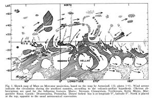
  Source McLaughlin, D. B.: Wind patterns and volcanoes on Mars. The Observatory, Vol. 74, p. 166-168 (1954) McLaughlin, D. B.: Interpretation of Some Martian Features. Publications of the Astronomical Society of the Pacific, Vol. 66, No. 391, p.161

An Explorer’s Guide to Mars

An Explorer’s Guide to Mars

The Planetary Society 1986. Detail. https://www.geographicus.com/P/AntiqueMap/GuidetoMars-planetarysociety-1986

Lunar Farside Chart

Lunar Farside Chart

Ross, Herbert S. Photo archived from Ebay Canada No further information known

Ginn Moon Map

Ginn Moon Map

1966-67 Ross, Herbert S. https://collections.lib.uwm.edu/digital/collection/agdm/id/21287/

Doherty’s map of Mars

Doherty’s map of Mars

Venera Map of Venus

Venera Map of Venus

Bazilevskiy AT 1989 The planet next door. Sky and Telescope, April 1989, p 368  

Early sketch maps of Phobos (1989)

Early sketch maps of Phobos (1989)

Housden’s maps and infographics of Mars hydrology (1914)

Housden’s maps and infographics of Mars hydrology (1914)

Housden CE 1914 The riddle of Mars the planet. Longmans, Green and Co. London, New York, Bombay, Calcutta

Meyers Konversations-Lexikon map of Mars (1888)

Meyers Konversations-Lexikon map of Mars (1888)

A rare map where north is up. Based on Schiaparelli.  

Mottoni – Slipher map of Mars

Mottoni – Slipher map of Mars

Motton G, 1967 Cartografia del Pianeta Marte Basata su Documentazione Fotografica Internazionale a Partire dal 1907. Opposizioni dal 1911 al 1920. Pubblicazioni dell’Osservatorio Astronomico di Milano-Merate, vol. 18, pp.1-29

Lopez and Escalante’s maps of Mars (1956)

Lopez and Escalante’s maps of Mars (1956)

Escalante Lopez López E, Escalante FJ 1963 El planeta Marte : 1907-1956 ; areografía, areología, bioareografía y climatología, la vida en su superficie. Mexico DF p52

Trumpler’s map of Mars (1924)

Trumpler’s map of Mars (1924)

  Trumpler, RJ 1927 Observations of Mars at the opposition of 1924. Lick Observatory Bulletin 13, 387, Berkeley, plates 3-4. University of California Press, [1927], p. 19-45, 5 leaves of plates : ill. ; 31 cm

Explanation
Column name Column description
Catalog ID (M) N/A
Title Title of map
Author Name of mapper(s), or author, PI, map editor, illustrator, etc. with roles
Nationality Nationality of author
Start date Year when mapping began / or year or observation
Date of publication Year of publication or completion of manusctipt (empty if not published yet)
Body Target name (planetary body)
Online Online references about the map
Projection Projection of map. 2-hemisphere is shown here.
Scale N/A
Orientation Orientation of map [north up, south up] – only for historic maps (north: cartographic tradition, south: astronomical tradition)
Publication type The type of work that contains the map. [standalone, journal, conference, atlas, book figure, book supplement, book plate, encyclopedia, multisheet, digital]
Type, purpose Type of map purpose [generic, outreach, science, citizen, surface operation (pre mission), landing site (post mission), observer, opposition, index, reference, eclipse/transit/occultation] generic: not defined, outreach: maps for the general public made b
Primary Nomenclature Laguage(s) of nomenclature displayed on the map [Latin, English etc., IAU, informal]. Latin for Latin nomenclature prior to IAU.
Ref (map) Full reference of map publication or publication that contains the map
DOI DOI number of map
ID (publication) ID of map publication or figure number
Origin type If this map is not original, the following codes are used: [L: language variant, N: new print, U: updated edition, C: copied / modified from another map, R: renovation map (digital version of paper map with slight changes), F facsimile. RP: republished in
Origin ID Any maps that this map is based on or copied from. Database ID of original map.
Based on map Name of mapper
Base (spacecraft, telescope) Name of spacecraft / instrument
Original title Title of map in original langage (if not English)
Publisher Name of Publisher; manuscript or self-published. For journals and conferences, the name of the journal or conference.
Coverage Coverage of map [global, hemispheric, regional, local, landing site, landing ellipse, traverse]
Target location IAU name of target feature (if named) or near side, far side etc. (If nothing noted, it is global)
Country Country of Publisher (original/translation)
Type, content Type of map [photo, map, sketch map, drawing, globe, tactile, data]. Data for raster datasets. For vector data, see Feature DB. Drawing: no grid, scale, projection etc.
Image base Base theme of the map [shaded relief, photomosaic, photo, none]
Theme Theme of map [visual, albedo, radar, low sun, topography, elevation, geology, geomorphology, art, nomenclature reference, feature, landing site reference, opposition map, event (eclipse etc) etc.]. Low sun is optical photo with shadows and no albedo. Vis
Technique Cartographic technique [imagemap, datamap, cartographic map, unit map, airbrush, pencil, line drawing/outline, contour lines, DEM, DIM, shaded relief / hillshading, raster data etc.]
Style Details on style
Method Method how the data was obtained
Mapping scale Scale of mapping
Resolution Raster dataset resoltion [m/pixel]
Short Reference Short form of reference to the map publication
GIS / data URL where GIS or original spatial data is
Data provider N/A
Profession Profession of author (for historic maps)
Designator Sheet designator terms following Greeley and Batson (1990) Planetary Mapping. Cambridge University Press. – only if displayed on the map. First letter: target body, 5M: scale, 90/0 etc: center coordinates, OM – orthophotomosaic , T – Topographic data (nom
Control Controlled, semi-controlled, uncontrolled
Note on control Base of control
Series title Title of map series
Number of maps (in work) N/A
Number of quads N/A
Quad ID Quad ID (or quads IDs) contained on the map
Map Diameter N/A
Map width cm N/A
Map height cm N/A
Map width px N/A
Map height px N/A
Base type Type of instrument of observation of base data [naked eye, telescope, spacecraft, space telescope, lander]
Location of copy Library or archive where manuscript or rare copy is kept
Ref (literature) Reference – literature about the map, may be the source of data if the map is not available. Separated with # symbols.
Status (2017) Status of mapping [complete, in progress, in review] (mostly for USGS maps)
Aim Original aim of mapping, if available
Notes Any comments, remarks [Long text, may be multiple paragraphs]
Secondary nomenclature Other languages of the nomenclature
Nomenclature Notes Remarks on nomenclature
Photo note N/A
Reference frame ID from RefFrames
web2 Online references about the map
web3 Online references about the map
web4 Online references about the map
ocentric/ographic Map coordinate [planetographic, planetocentric]
N N/A
S N/A
W 360E N/A
E 360E N/A
W 180 N/A
E 180 N/A
W 360W N/A
R 360W N/A
fig1 N/A
fig1 caption N/A
fig2 N/A
fig2 caption N/A
fig3 N/A
fig3 caption N/A
fig4 N/A
fig4 caption N/A
fig5 N/A
fig5 caption N/A
STATUS N/A
Sum $180