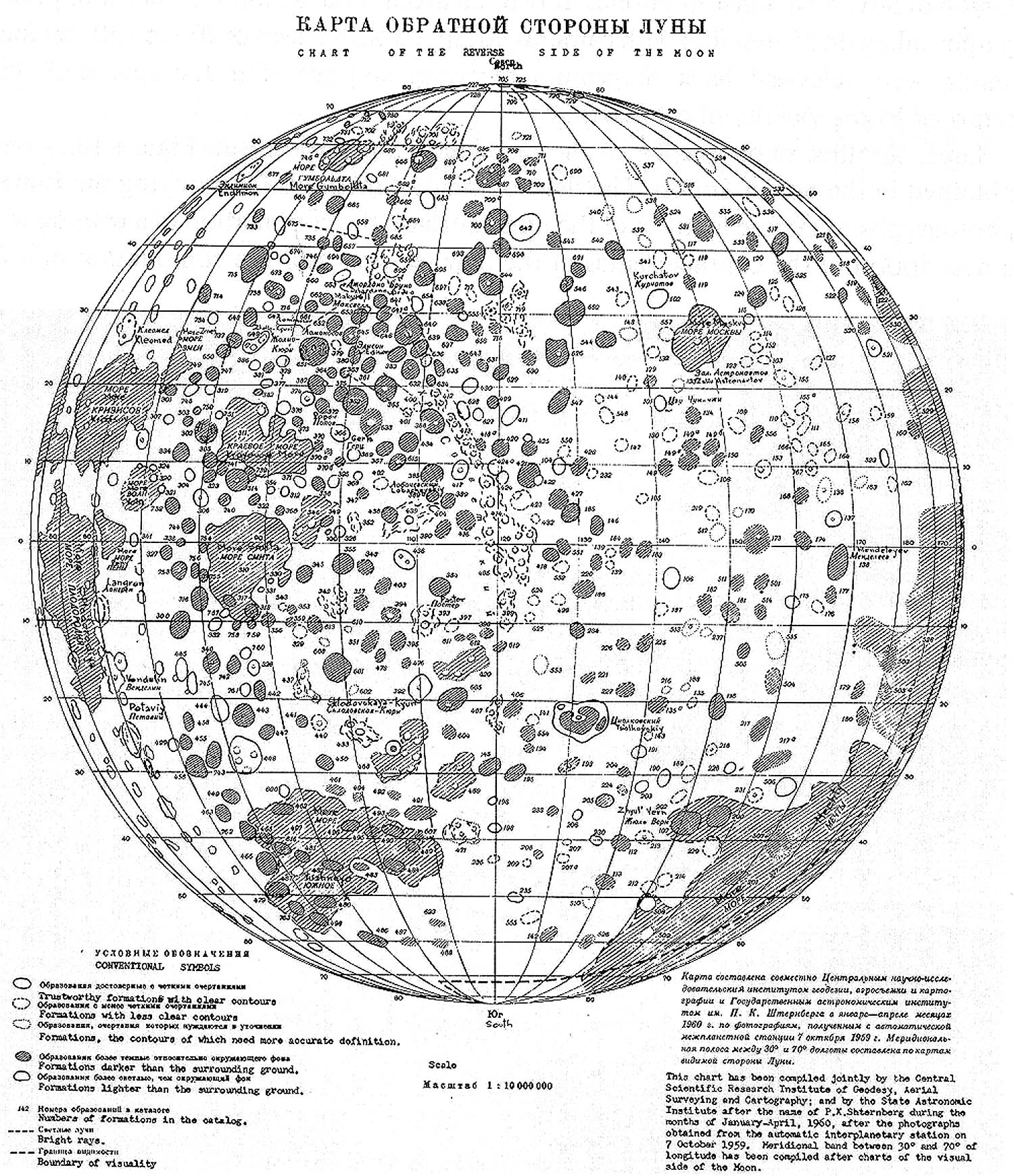
Sternberg Institute’s Chart of the Reverse Side of the Moon (1960)

Atlas Obratnoj Storony Luny (Part 1)
Akademiya Nauk SSSR Moskva 1960.
Includes a map of the far side in 4 pages
1:10 000 000
(It is centered at 120 deg, partly overlaps the near side)
Cartographic editor: Yurii Naumovich Lipsky
Based on Luna-3 photographs

lipsky1960

Comment by Zh. F. Rodionova:
За всю историю картографирования Луны до начала космических полетов (т.е. примерно за 350 лет) было создано около 120 рисунков, карт и атласов видимой стороны Луны. Интересно, что в России в этот период, насколько нам известно, не было составлено ни одной лунной карты. Однако, первая карта обратной стороны Луны была создана именно в России (СССР) по самым первым снимкам, переданным космическим зондом “Луна 3” в 1959 г. Впервые увиденные землянами детали обратной стороны Луны показаны на карте условными знаками, их координаты определены в единой селенографической системе, а 18-ти крупнейшим объектам присвоены наименования. Полученные на Земле по радиоканалу снимки были сильно искажены помехами, но методика, разработанная в Государственном астрономическом институте им. П.К. Штернберга (МГУ) под руководством Ю.Н. Липского (1909-1978) позволила выявить множество деталей рельефа невидимого полушария. На этой карте впервые появились Море Москвы и Море Мечты, кратеры Циолковский, Джордано Бруно, Менделеев, Склодовская-Кюри и другие. Светлое протяженное образование было названо Хребтом Советским, однако оно не подтвердилось последующими съемками.

During entire history of cartography of the Moon prior to the beginning of space flights (i.e. approximately in 350 years) it was created about 120 figures, maps and atlases of the visible side of the Moon. It is interesting that in Russia during this period, as far as we know, it was not comprised not one lunar map. However, the first map of the far side of the Moon was created precisely in Russia (USSR) on the very first photographs, transmitted by the space probe of “Luna-3” in 1959. For the first time seen by earthlings components of the far side of the moon are shown on the map by arbitrary symbols, their coordinates are determined in the united selenographic system, and to the largest 18 objects are appropriated designations. Photographs obtained on the Earth on the radio channel were strongly distorted by interferences, but the procedure, developed in the state Sternberg Astronomical Institute (MGU) under the management Yurii Naumovich Lipsky (1909-1978) made it possible to reveal many components of the relief of invisible hemisphere. On this map for the first time appeared the sea of Moscow (Море Москвы) and the sea of Dream (Море Мечты), craters Tsiolkovskiy, Giordano Bruno, Mendeleyev, Sklodowska-Curie, etc. The bright extensive formation was named Soviet Ridge (Хребтом Советским); however, it was not confirmed by the subsequent surveys.

Source of the map:


Left: Luna-3 image from Atlas Obratnoj Storony Luny (Tsast’ 2) 1967 Right: Image composite by P Stooke (2007)

A globe of the Moon using Luna 3 images has been created in 1960 1:13 600 000 prepared by Sternberg Institute (GAISH) and TSNIIGAiK. (Rodionova 1991)


At the time of Luna 3 (1959 Oct 7) the only farside map was by Wilkins and Moore.

New names:

The most prominent dark floored crater: Tsiolkovskiy
Astronaut Bay (Zaliv Astronavtov), a part of Mare Moscoviense, now dropped, was named before any astronauts had flown in space. (the term cosmonaut was not used)
Montes Sovieticii: were later found to be crater rays superimposed on a basin rim
More Mechty (Sea of Dreams) commemorates Luna 1 which was first named Mechta. At first it was much larger that Mare Ingenii today as it was the dark floor of the western edge of the SPA Basin.

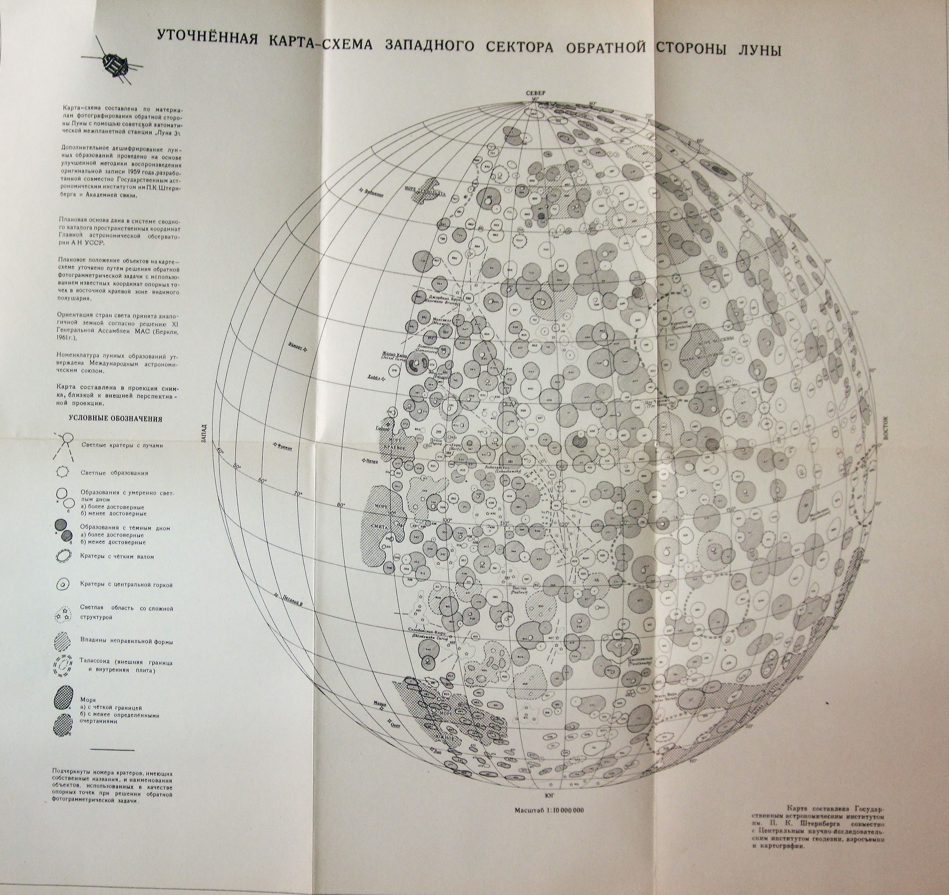
Lunar Farside Atlas, Part II.

farside_part2_front

Atlas Obratnoj Storony Luny (Tsast’ 2)
Akademiya Nauk SSSR Moskva 1967
1:10 000 000
(It is centered at 120 deg)

farside2

Sketch of the farside

luna-3_sketch

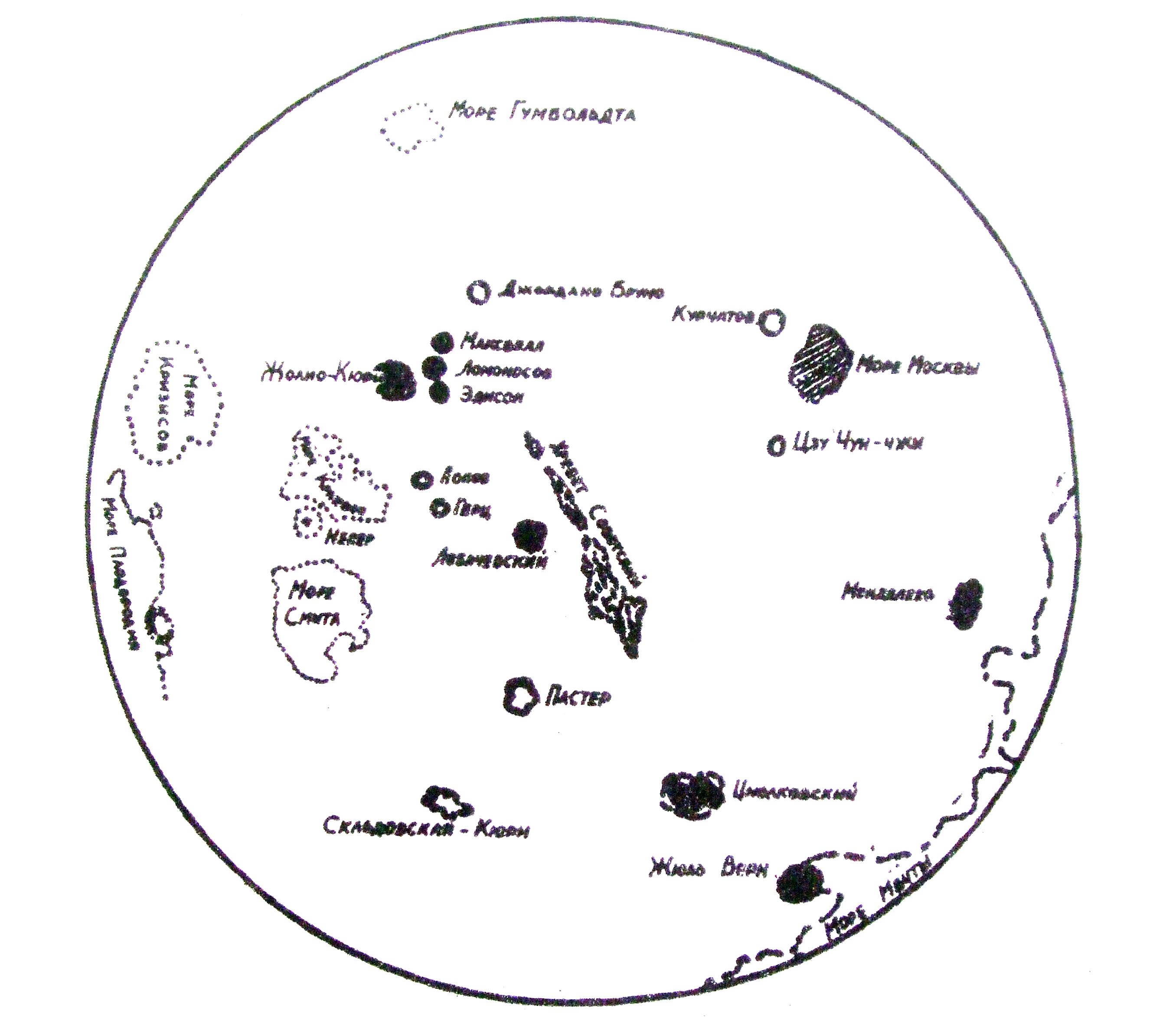
From the front page of: Issledovanie Luny v SSSR Ed. V. Polyakov
The 1st scheme from Luna 3 images.

„No one wanted to make a map from Luna 3 materials. At Sternberg Institute it was done by the leadership of prof. Lipsky who tried to make the map. The images were of bad quality but it was important to make maps since this way they could give the first names of the farside so they had to find relief features. Some were found, mostly dark spots. The mapping was succesful even from this low quality materials, since most of the features later proved to really exist.” (Shingareva 2009)

Explanation
Column name Column description
Catalog ID (M) N/A
Title Title of map
Author Name of mapper(s), or author, PI, map editor, illustrator, etc. with roles
Nationality Nationality of author
Start date Year when mapping began / or year or observation
Date of publication Year of publication or completion of manusctipt (empty if not published yet)
Body Target name (planetary body)
Online Online references about the map
Projection Projection of map. 2-hemisphere is shown here.
Scale N/A
Orientation Orientation of map [north up, south up] – only for historic maps (north: cartographic tradition, south: astronomical tradition)
Publication type The type of work that contains the map. [standalone, journal, conference, atlas, book figure, book supplement, book plate, encyclopedia, multisheet, digital]
Type, purpose Type of map purpose [generic, outreach, science, citizen, surface operation (pre mission), landing site (post mission), observer, opposition, index, reference, eclipse/transit/occultation] generic: not defined, outreach: maps for the general public made b
Primary Nomenclature Laguage(s) of nomenclature displayed on the map [Latin, English etc., IAU, informal]. Latin for Latin nomenclature prior to IAU.
Ref (map) Full reference of map publication or publication that contains the map
DOI DOI number of map
ID (publication) ID of map publication or figure number
Origin type If this map is not original, the following codes are used: [L: language variant, N: new print, U: updated edition, C: copied / modified from another map, R: renovation map (digital version of paper map with slight changes), F facsimile. RP: republished in
Origin ID Any maps that this map is based on or copied from. Database ID of original map.
Based on map Name of mapper
Base (spacecraft, telescope) Name of spacecraft / instrument
Original title Title of map in original langage (if not English)
Publisher Name of Publisher; manuscript or self-published. For journals and conferences, the name of the journal or conference.
Coverage Coverage of map [global, hemispheric, regional, local, landing site, landing ellipse, traverse]
Target location IAU name of target feature (if named) or near side, far side etc. (If nothing noted, it is global)
Country Country of Publisher (original/translation)
Type, content Type of map [photo, map, sketch map, drawing, globe, tactile, data]. Data for raster datasets. For vector data, see Feature DB. Drawing: no grid, scale, projection etc.
Image base Base theme of the map [shaded relief, photomosaic, photo, none]
Theme Theme of map [visual, albedo, radar, low sun, topography, elevation, geology, geomorphology, art, nomenclature reference, feature, landing site reference, opposition map, event (eclipse etc) etc.]. Low sun is optical photo with shadows and no albedo. Vis
Technique Cartographic technique [imagemap, datamap, cartographic map, unit map, airbrush, pencil, line drawing/outline, contour lines, DEM, DIM, shaded relief / hillshading, raster data etc.]
Style Details on style
Method Method how the data was obtained
Mapping scale Scale of mapping
Resolution Raster dataset resoltion [m/pixel]
Short Reference Short form of reference to the map publication
GIS / data URL where GIS or original spatial data is
Data provider N/A
Profession Profession of author (for historic maps)
Designator Sheet designator terms following Greeley and Batson (1990) Planetary Mapping. Cambridge University Press. – only if displayed on the map. First letter: target body, 5M: scale, 90/0 etc: center coordinates, OM – orthophotomosaic , T – Topographic data (nom
Control Controlled, semi-controlled, uncontrolled
Note on control Base of control
Series title Title of map series
Number of maps (in work) N/A
Number of quads N/A
Quad ID Quad ID (or quads IDs) contained on the map
Map Diameter N/A
Map width cm N/A
Map height cm N/A
Map width px N/A
Map height px N/A
Base type Type of instrument of observation of base data [naked eye, telescope, spacecraft, space telescope, lander]
Location of copy Library or archive where manuscript or rare copy is kept
Ref (literature) Reference – literature about the map, may be the source of data if the map is not available. Separated with # symbols.
Status (2017) Status of mapping [complete, in progress, in review] (mostly for USGS maps)
Aim Original aim of mapping, if available
Notes Any comments, remarks [Long text, may be multiple paragraphs]
Secondary nomenclature Other languages of the nomenclature
Nomenclature Notes Remarks on nomenclature
Photo note N/A
Reference frame ID from RefFrames
web2 Online references about the map
web3 Online references about the map
web4 Online references about the map
ocentric/ographic Map coordinate [planetographic, planetocentric]
N N/A
S N/A
W 360E N/A
E 360E N/A
W 180 N/A
E 180 N/A
W 360W N/A
R 360W N/A
fig1 N/A
fig1 caption N/A
fig2 N/A
fig2 caption N/A
fig3 N/A
fig3 caption N/A
fig4 N/A
fig4 caption N/A
fig5 N/A
fig5 caption N/A
STATUS N/A
Sum $180