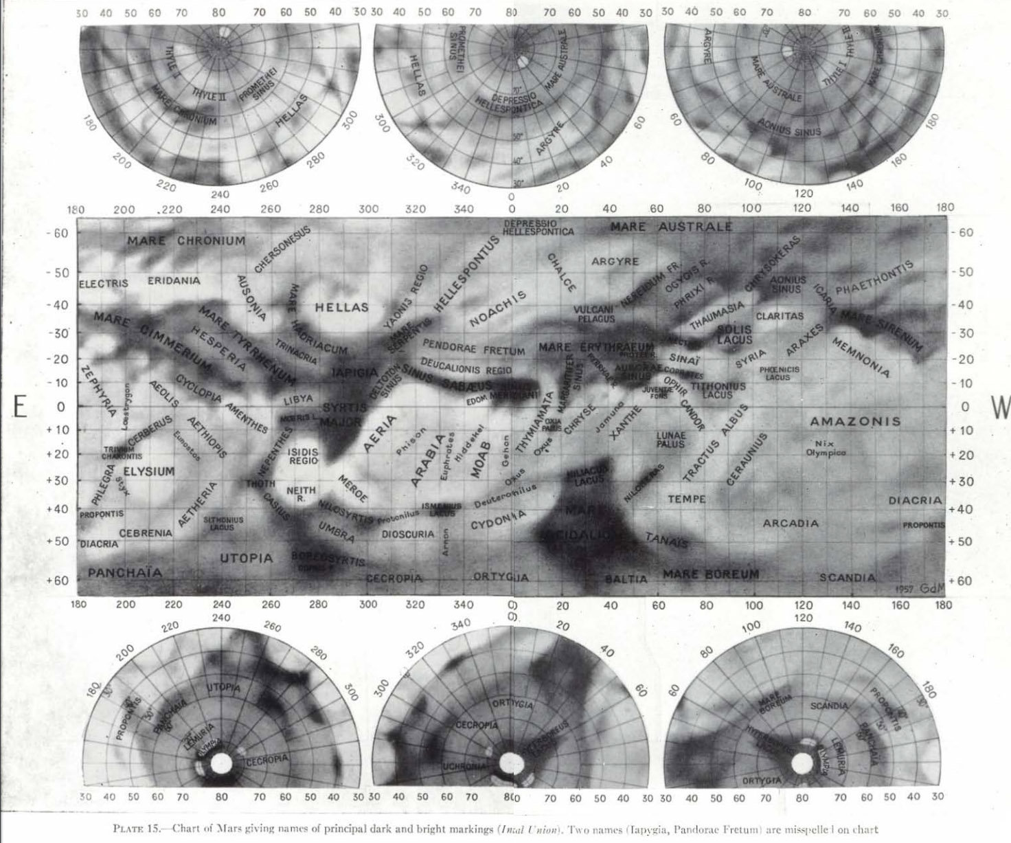
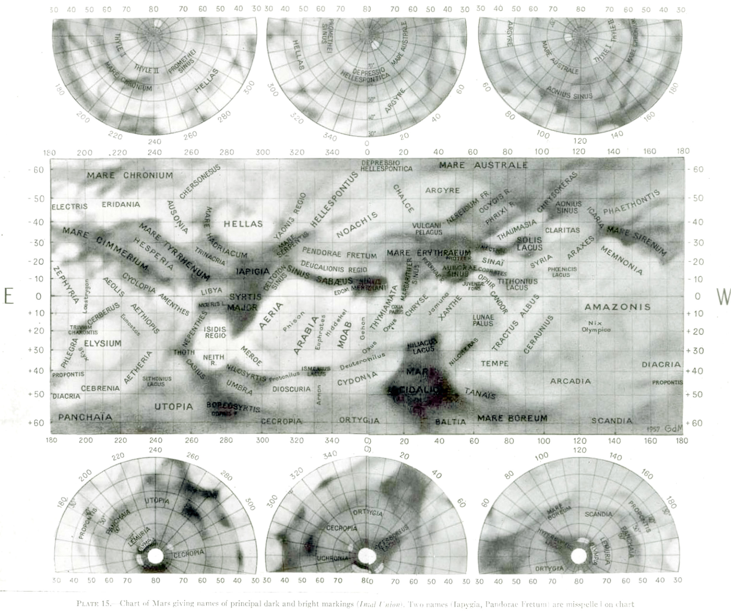
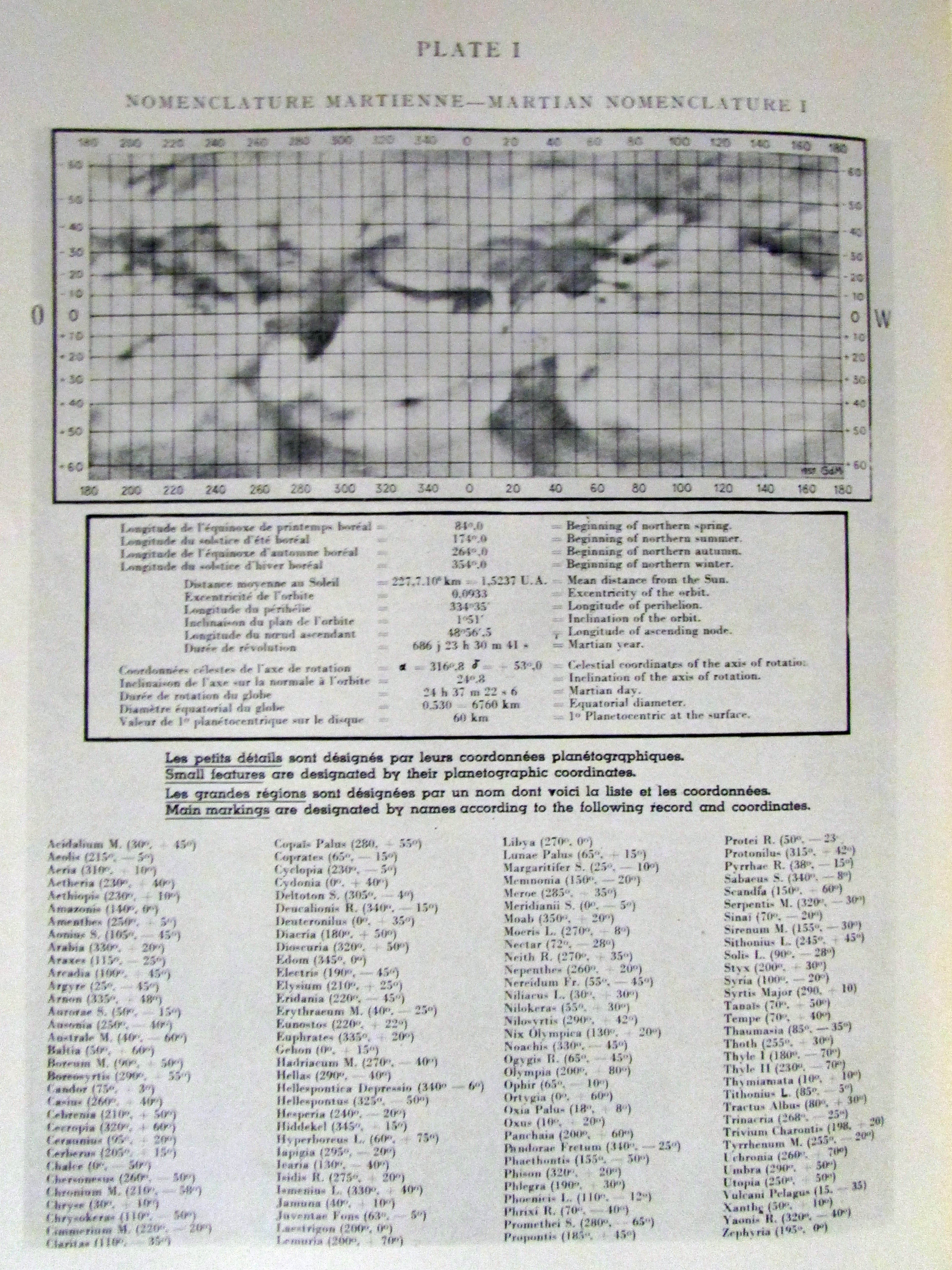
Mottoni’s IAU Map of Mars (1941-52)

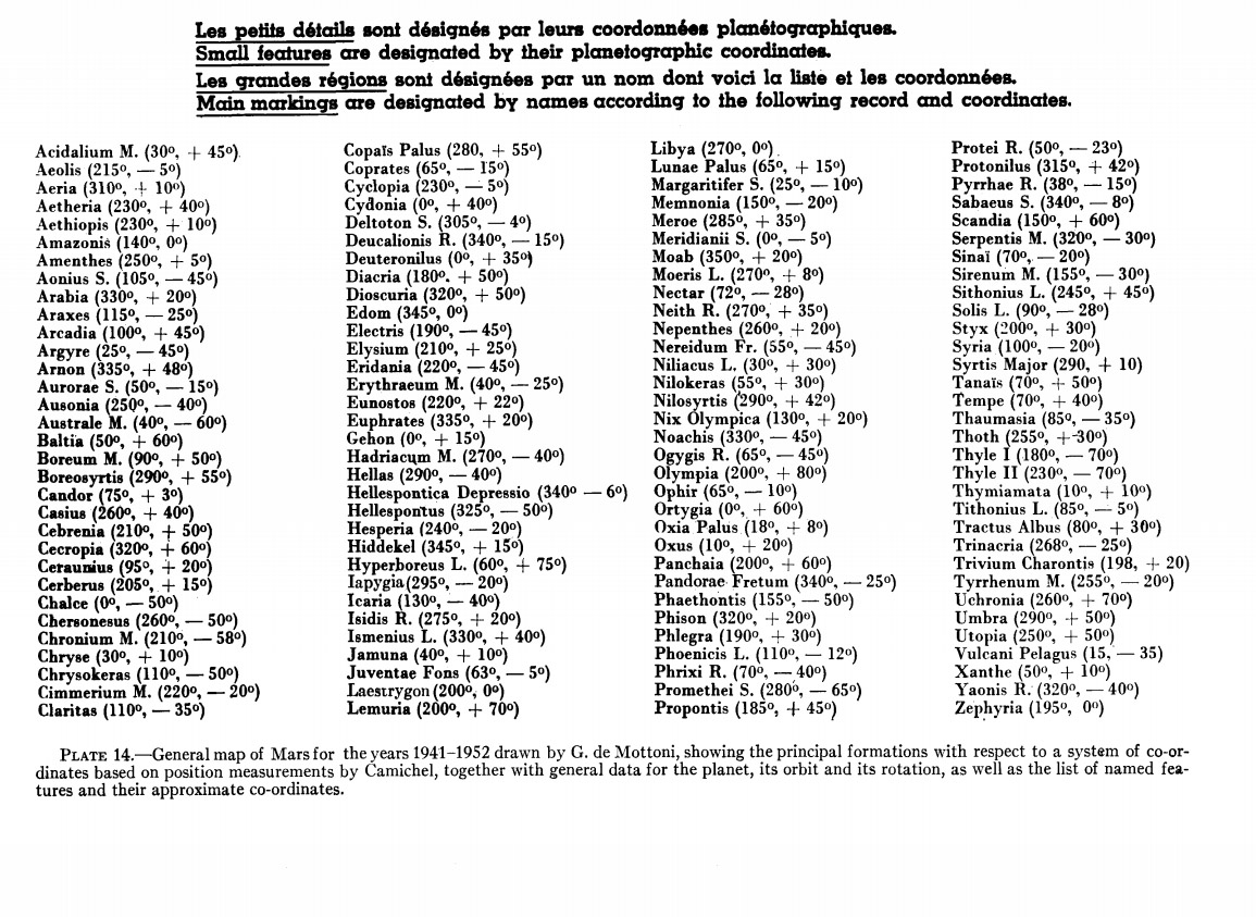
Coordinate system created using Juventae Fons observations for determinig rotation and 260 control points by Camichel.  40 was used in this map.

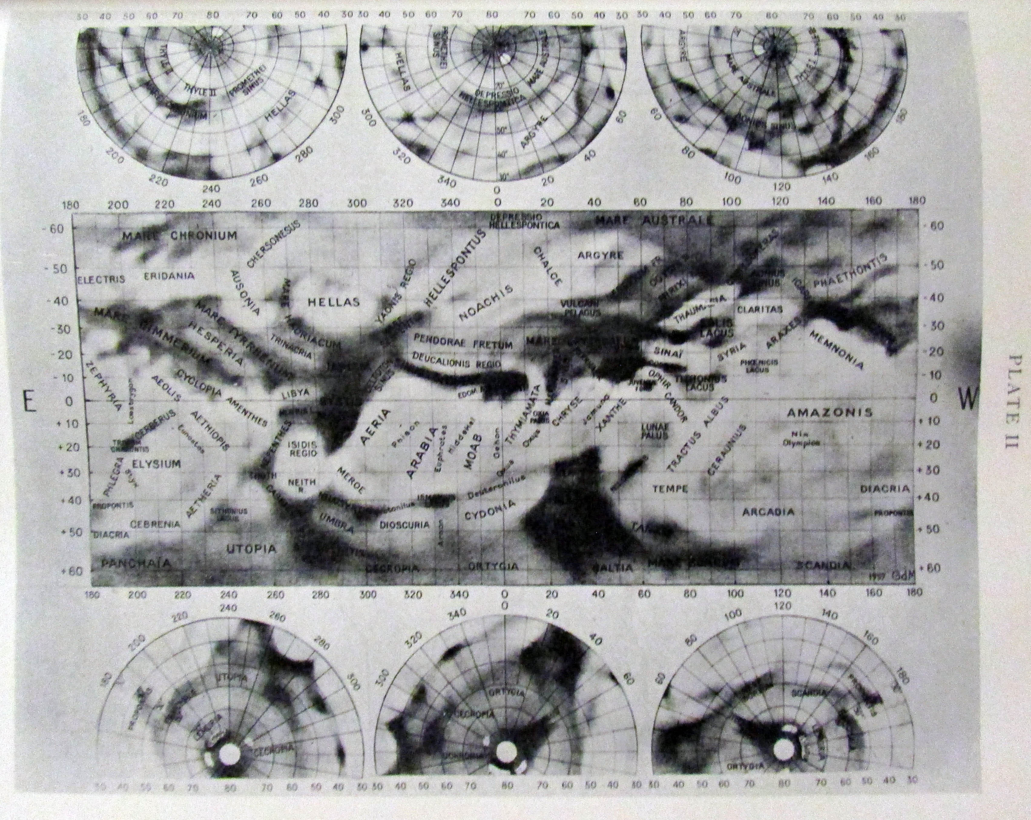
This map was made by Dr. de Mottoni (Giardini Glauco de Mottoni y Palacios), and presented at the 1958 Moscow IAU meeting. It represents the avegare positions of surface markings observed 1941-52.

Source: A. Dollfus: Visual and photographic studies off planets at the Pic du Midi. In: Planets and Satellites, GP Kuiper and B Middlehurst, eds. Chicago Univ Press 543-571.

* *

IAU adapted this map as the only officially approved Martian albedo nomenclature still in effect.

From the Transcations:

“CHARTS OF THE PLANET MARS
The two accompanying charts (I and II) are intended to provide a simple method of designating and identifying spots on the surface of the planet Mars. The system, adopted and recommended by the Intemational Astronomical Union, is in conformity with that used since the last century, but it is simplified and adapted to present-day requirements.
Method of designation Main features are designated each by a name drawn from mythology, in accordance with the former classical system. Each name refers to the whole of a district; it indicates the locality on which observa-tions or spectroscopic, photometric, radiometric, polarimetric or other measures have been carried out. Small features are designated by their planetocentric coordinates mad off from the charts. These charts are accurate enough to determine present-day co-ordinates; they provide an absolute standard of reference. The co-ordinates are expressed by the longitude, followed by the latitude, between brackets—for example: (039°, — 20°) ; (22°, 281. However small and numerous may be the details revealed by powerful instruments of observation, this system of reference will enable them to be located, even though many of them may be ephemeral or variable.
His to use the charts To designate a spot seen on the planet, the observer should examine the region on the chart containing names (Plate II), and should read off the name or the co-ordinates. To find a named feature, he should consult the alphabetical list (which is below the chart without names (Plate I)) for the co-ordinates, which will enable the position of the feature to be found on the chart. ”

mars-picdumidi4mars-picdumidi3

mars-picdumidi2mars-picdumidi1

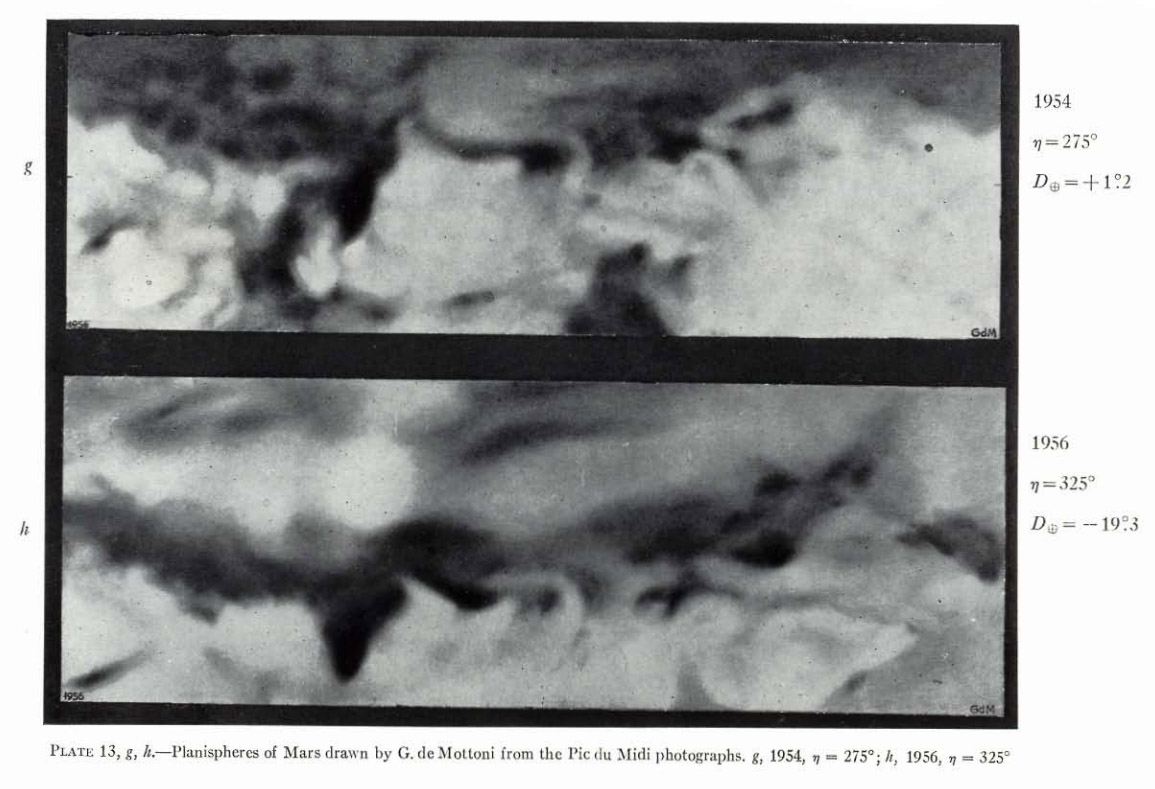
Two of the original drawings, using control points

mars58mars1958iau2mars-iau-1958

Measurements made at Pic du Midi 1941-54 by H. Camichel. Of 260 control points, 38 were used in the map.

The map was produced from six “planisphere” maps by G. de Mottoni with the help of Pic du Midi photographs taken during 1941, 43, 46, 48, 50, 52 oppositions, respectively.

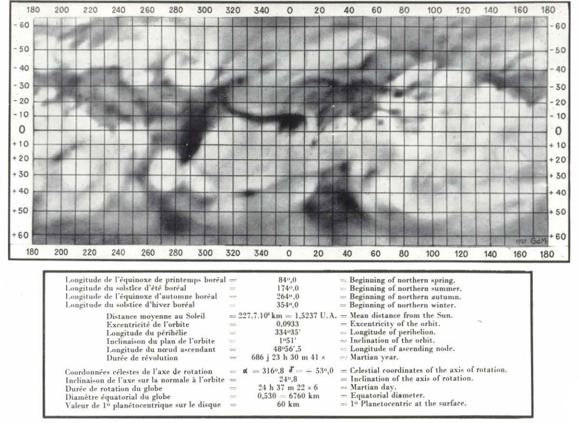
+60- -60 latitudes in Mercator, following Schiaparelly,  and polar azimuthal equidistant projection.

Source: Transactions of the International Astronomical Union, Moscow, August 12-20, 1958: Cambridge University Press, v. 10, pl. 1, p. 262.

Explanation
Column name Column description
Catalog ID (M) N/A
Title Title of map
Author Name of mapper(s), or author, PI, map editor, illustrator, etc. with roles
Nationality Nationality of author
Start date Year when mapping began / or year or observation
Date of publication Year of publication or completion of manusctipt (empty if not published yet)
Body Target name (planetary body)
Online Online references about the map
Projection Projection of map. 2-hemisphere is shown here.
Scale N/A
Orientation Orientation of map [north up, south up] – only for historic maps (north: cartographic tradition, south: astronomical tradition)
Publication type The type of work that contains the map. [standalone, journal, conference, atlas, book figure, book supplement, book plate, encyclopedia, multisheet, digital]
Type, purpose Type of map purpose [generic, outreach, science, citizen, surface operation (pre mission), landing site (post mission), observer, opposition, index, reference, eclipse/transit/occultation] generic: not defined, outreach: maps for the general public made b
Primary Nomenclature Laguage(s) of nomenclature displayed on the map [Latin, English etc., IAU, informal]. Latin for Latin nomenclature prior to IAU.
Ref (map) Full reference of map publication or publication that contains the map
DOI DOI number of map
ID (publication) ID of map publication or figure number
Origin type If this map is not original, the following codes are used: [L: language variant, N: new print, U: updated edition, C: copied / modified from another map, R: renovation map (digital version of paper map with slight changes), F facsimile. RP: republished in
Origin ID Any maps that this map is based on or copied from. Database ID of original map.
Based on map Name of mapper
Base (spacecraft, telescope) Name of spacecraft / instrument
Original title Title of map in original langage (if not English)
Publisher Name of Publisher; manuscript or self-published. For journals and conferences, the name of the journal or conference.
Coverage Coverage of map [global, hemispheric, regional, local, landing site, landing ellipse, traverse]
Target location IAU name of target feature (if named) or near side, far side etc. (If nothing noted, it is global)
Country Country of Publisher (original/translation)
Type, content Type of map [photo, map, sketch map, drawing, globe, tactile, data]. Data for raster datasets. For vector data, see Feature DB. Drawing: no grid, scale, projection etc.
Image base Base theme of the map [shaded relief, photomosaic, photo, none]
Theme Theme of map [visual, albedo, radar, low sun, topography, elevation, geology, geomorphology, art, nomenclature reference, feature, landing site reference, opposition map, event (eclipse etc) etc.]. Low sun is optical photo with shadows and no albedo. Vis
Technique Cartographic technique [imagemap, datamap, cartographic map, unit map, airbrush, pencil, line drawing/outline, contour lines, DEM, DIM, shaded relief / hillshading, raster data etc.]
Style Details on style
Method Method how the data was obtained
Mapping scale Scale of mapping
Resolution Raster dataset resoltion [m/pixel]
Short Reference Short form of reference to the map publication
GIS / data URL where GIS or original spatial data is
Data provider N/A
Profession Profession of author (for historic maps)
Designator Sheet designator terms following Greeley and Batson (1990) Planetary Mapping. Cambridge University Press. – only if displayed on the map. First letter: target body, 5M: scale, 90/0 etc: center coordinates, OM – orthophotomosaic , T – Topographic data (nom
Control Controlled, semi-controlled, uncontrolled
Note on control Base of control
Series title Title of map series
Number of maps (in work) N/A
Number of quads N/A
Quad ID Quad ID (or quads IDs) contained on the map
Map Diameter N/A
Map width cm N/A
Map height cm N/A
Map width px N/A
Map height px N/A
Base type Type of instrument of observation of base data [naked eye, telescope, spacecraft, space telescope, lander]
Location of copy Library or archive where manuscript or rare copy is kept
Ref (literature) Reference – literature about the map, may be the source of data if the map is not available. Separated with # symbols.
Status (2017) Status of mapping [complete, in progress, in review] (mostly for USGS maps)
Aim Original aim of mapping, if available
Notes Any comments, remarks [Long text, may be multiple paragraphs]
Secondary nomenclature Other languages of the nomenclature
Nomenclature Notes Remarks on nomenclature
Photo note N/A
Reference frame ID from RefFrames
web2 Online references about the map
web3 Online references about the map
web4 Online references about the map
ocentric/ographic Map coordinate [planetographic, planetocentric]
N N/A
S N/A
W 360E N/A
E 360E N/A
W 180 N/A
E 180 N/A
W 360W N/A
R 360W N/A
fig1 N/A
fig1 caption N/A
fig2 N/A
fig2 caption N/A
fig3 N/A
fig3 caption N/A
fig4 N/A
fig4 caption N/A
fig5 N/A
fig5 caption N/A
STATUS N/A
Sum $180