Hypsometric globe of Mars (2012)

Publisher: Sternberg State Astronomical Institute (SAI) in cooperation with the Department of Cartography and Geoinformatics Faculty of Geography Moscow State University
Source of data: MOLA; showing landing sites
Cartographers: Zh. F. Rodionova, J. Brekhovskikh (Space Research Institute) (color scheme, based the previous Hypsometric map of Mars, scale 1:26 000 000 [Ilukhina, 2004])
Height scheme: The height scale contains 21 step heights. To a height of 8 km the contour interval is 1 km. Up to 12 km the interval is 2 km. Above 12 km the interval is given within 10 km.
Technology: Thermoplastic globe.
The technology to create the globe using thermoplastic materials provides for forming the hemispheres of the sheets with the printed image on them and gluing the hemispheres at the equator. The original hemisphere prepared with the image is placed in the plastic molding device, and at high temperature using a metal template the hemispheres are pressed. Western and Eastern hemispheres were recut as the northern and southern hemispheres in the azimuthal projection taking into account the law of deformation occurring during forming of the p lane in the hemisphere. Transforming the original cartographic image on the plane into an undistorted image on the field in this way can only be done, if the distortion of the lengths of the meridians in the original projections will be constant equal to m = 2/, and the distortion of the lengths of the parallels of latitude be a function of the form n = (-2):(cos) (Boginskiy 1990). This requirement corresponds to an azimuthal equidistant projection to the plane of section passing through the center of Mars. The projection is an orthogonal grid. The parallels are represented by equally spaced concentric circles, and meridians – the straight lines emanating from the center of the circles. When placing the original map, we took into account the fact that when forming the hemispheres the original image is stretched by more than half. As the tension is not even the names of relief forms were arranged parallel to the equator.
Softwares used: ArcGis10, Corel Draw

References:
Zh. F. Rodionova , J. A. Brekhovskikh [Родионова Ж.Ф., Бреховских Ю.А]  (2013) Hypsometric Globe of Mars – 3D Model of the Planet (#610) . ICC 2013, Dresden.
Ilyukhina J.A., Rodionova Zh.F. (2004) Gipsometricheskaya karta Marsa. 1:26 000 000. Moscow, Nauka.
Новая карта рельефа Марса  http://ziv.telescopes.ru/rubric/astronomy/?pub=8

hypso_2013
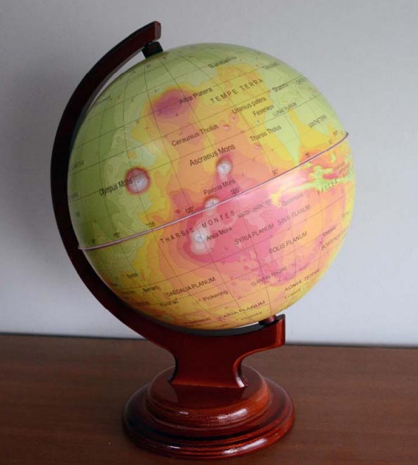
One of the 10 test globes

sai_hypso_globe
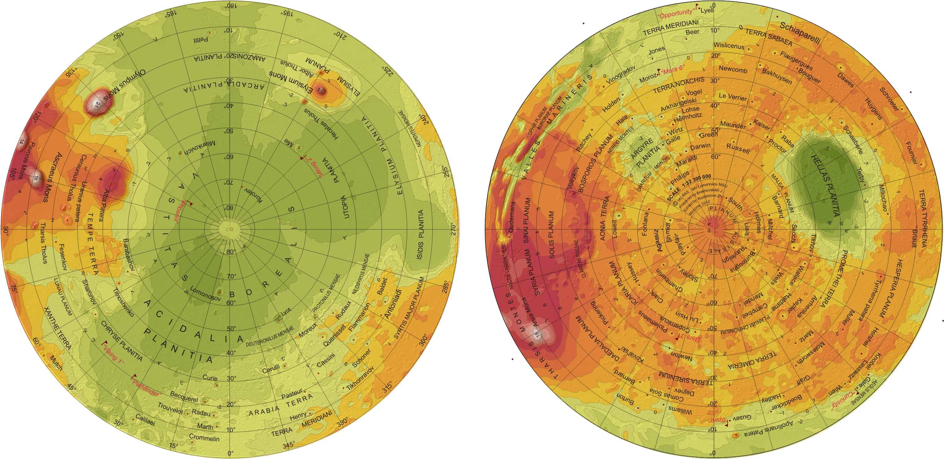
High-resolution image of the original prints

two_mars_globes_013
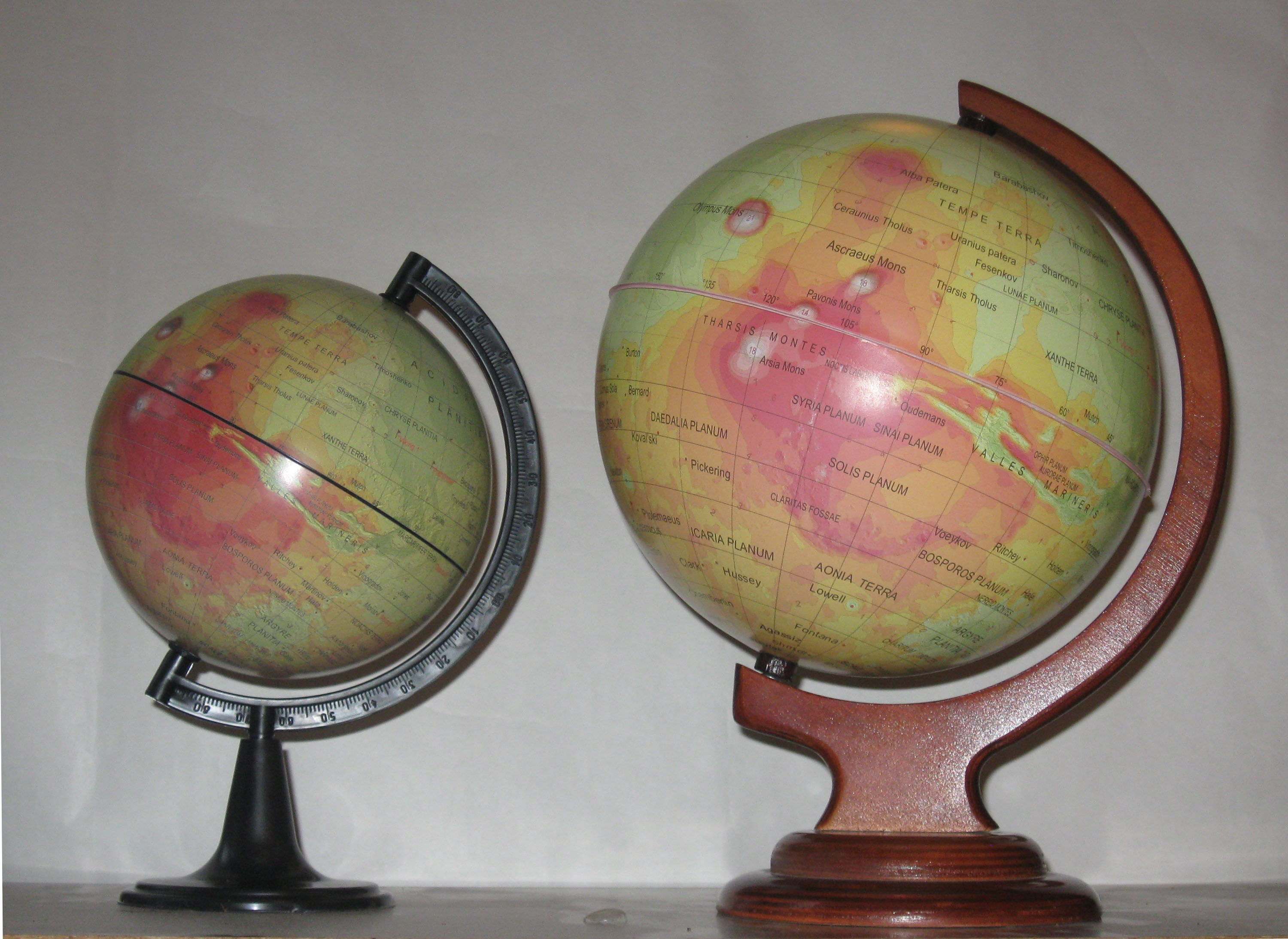
Two size variants of the Globes, 2013

Explanation
Column name Column description
Catalog ID (M) N/A
Title Title of map
Author Name of mapper(s), or author, PI, map editor, illustrator, etc. with roles
Nationality Nationality of author
Start date Year when mapping began / or year or observation
Date of publication Year of publication or completion of manusctipt (empty if not published yet)
Body Target name (planetary body)
Online Online references about the map
Projection Projection of map. 2-hemisphere is shown here.
Scale N/A
Orientation Orientation of map [north up, south up] – only for historic maps (north: cartographic tradition, south: astronomical tradition)
Publication type The type of work that contains the map. [standalone, journal, conference, atlas, book figure, book supplement, book plate, encyclopedia, multisheet, digital]
Type, purpose Type of map purpose [generic, outreach, science, citizen, surface operation (pre mission), landing site (post mission), observer, opposition, index, reference, eclipse/transit/occultation] generic: not defined, outreach: maps for the general public made b
Primary Nomenclature Laguage(s) of nomenclature displayed on the map [Latin, English etc., IAU, informal]. Latin for Latin nomenclature prior to IAU.
Ref (map) Full reference of map publication or publication that contains the map
DOI DOI number of map
ID (publication) ID of map publication or figure number
Origin type If this map is not original, the following codes are used: [L: language variant, N: new print, U: updated edition, C: copied / modified from another map, R: renovation map (digital version of paper map with slight changes), F facsimile. RP: republished in
Origin ID Any maps that this map is based on or copied from. Database ID of original map.
Based on map Name of mapper
Base (spacecraft, telescope) Name of spacecraft / instrument
Original title Title of map in original langage (if not English)
Publisher Name of Publisher; manuscript or self-published. For journals and conferences, the name of the journal or conference.
Coverage Coverage of map [global, hemispheric, regional, local, landing site, landing ellipse, traverse]
Target location IAU name of target feature (if named) or near side, far side etc. (If nothing noted, it is global)
Country Country of Publisher (original/translation)
Type, content Type of map [photo, map, sketch map, drawing, globe, tactile, data]. Data for raster datasets. For vector data, see Feature DB. Drawing: no grid, scale, projection etc.
Image base Base theme of the map [shaded relief, photomosaic, photo, none]
Theme Theme of map [visual, albedo, radar, low sun, topography, elevation, geology, geomorphology, art, nomenclature reference, feature, landing site reference, opposition map, event (eclipse etc) etc.]. Low sun is optical photo with shadows and no albedo. Vis
Technique Cartographic technique [imagemap, datamap, cartographic map, unit map, airbrush, pencil, line drawing/outline, contour lines, DEM, DIM, shaded relief / hillshading, raster data etc.]
Style Details on style
Method Method how the data was obtained
Mapping scale Scale of mapping
Resolution Raster dataset resoltion [m/pixel]
Short Reference Short form of reference to the map publication
GIS / data URL where GIS or original spatial data is
Data provider N/A
Profession Profession of author (for historic maps)
Designator Sheet designator terms following Greeley and Batson (1990) Planetary Mapping. Cambridge University Press. – only if displayed on the map. First letter: target body, 5M: scale, 90/0 etc: center coordinates, OM – orthophotomosaic , T – Topographic data (nom
Control Controlled, semi-controlled, uncontrolled
Note on control Base of control
Series title Title of map series
Number of maps (in work) N/A
Number of quads N/A
Quad ID Quad ID (or quads IDs) contained on the map
Map Diameter N/A
Map width cm N/A
Map height cm N/A
Map width px N/A
Map height px N/A
Base type Type of instrument of observation of base data [naked eye, telescope, spacecraft, space telescope, lander]
Location of copy Library or archive where manuscript or rare copy is kept
Ref (literature) Reference – literature about the map, may be the source of data if the map is not available. Separated with # symbols.
Status (2017) Status of mapping [complete, in progress, in review] (mostly for USGS maps)
Aim Original aim of mapping, if available
Notes Any comments, remarks [Long text, may be multiple paragraphs]
Secondary nomenclature Other languages of the nomenclature
Nomenclature Notes Remarks on nomenclature
Photo note N/A
Reference frame ID from RefFrames
web2 Online references about the map
web3 Online references about the map
web4 Online references about the map
ocentric/ographic Map coordinate [planetographic, planetocentric]
N N/A
S N/A
W 360E N/A
E 360E N/A
W 180 N/A
E 180 N/A
W 360W N/A
R 360W N/A
fig1 N/A
fig1 caption N/A
fig2 N/A
fig2 caption N/A
fig3 N/A
fig3 caption N/A
fig4 N/A
fig4 caption N/A
fig5 N/A
fig5 caption N/A
STATUS N/A
Sum $180