Moon

Karte des Mondes

Karte des Mondes

In: Karl Wilhelm Valentiner, 1881, Astronomische Bilder, Leipzig Author unknown.

Kulin’s Map of the Moon

Kulin’s Map of the Moon

  Nomenclature: latin In: Kulin György: A távcső világa. Királyi Magyar Természettudományi Társulat (Budapest), 1941 Supplement to the 1941 edition. Not included in later editions. Title: Map of the Moon, “after Braun” (?) With index of names. Kulin-Zerinváry, A távcső világa, 1958 edition. Without index. Notes on the possibility on life on the Moon, page […]

Cholnoky’s map of the Moon (193?)

Cholnoky’s map of the Moon (193?)

In: Cholnoky Jenő: A csillagok világa. Franklin társulat. 92. ábra p 189 [193?] “Ezt a Hold-térképet, amelyet nagyon alapos és mélyreható tanulmányozás után készítettem, egyik most készülő művemben is felhasználom.”  (Polgár Géza 1942: Örök fiatalok, akik látták a múltat. Dr. Vajna és Bokor, Budapest p110) Pencil drawing with hand-written labels. Nomenlcature in Hungarian. North-up. ca. 18×18 […]

Temperature map of the Moon

Temperature map of the Moon

Source: Zerinváry Szilárd: A Naprendszer élete. Művelt Nép Könyvkiadó, 1953, Budapest Origin of the map unknown. Caption: Temperature values on the Moon in the Sun-facing hemisphere.    

Map of the Volcanic Forms of the Moon (1974)

Source: Academy of Sciences of the USSR, Order of the Red Banner of Labour Geological Institute: Volcanism and Tectonics of the Mon. Nauka, Moscow 1974. Editors: AV Peive, VV Menner, VG Gerbova, PP Tomofeev, MS Markov. Карта вулкавических форм Луны А – схема расnоложенuя лuстов карты 1 – кратеры вулканичесного происхождения; 2 – нратеры предположитепьио […]

Sketch maps of Zond-3 probe images

Sketch maps of Zond-3 probe images

Дешифрование снимков полоценных амс зонд-3 составление карты-схемы и каталога выявленных образований. In: Атлас обратной строны луны часть II Atlas of the far side of the Moon, Part II. Moscow 1967. p 33-64.

Lohrmann’s Map of the Moon

Cartographer: Wilhelm Lohrmann Title: Topographie der sichtbaren Mondoberflaeche (Topography of the Visible Lunar Surface) Dresden: Auf Kosten des Verfassers, 1824. 25 sheets, hachure relief visualization and multiple gray shadings for albedo 1824 4 sheets Size  227 × 227 mm 1878 Full atlas published by Julius Schmidt, reissued in  1892  Mondkarte in 25 Sectionen und 2 Erlauterungstafeln / Herausgegeben von Dr. […]

The System of Lunar Craters (1963-1966)

The System of Lunar Craters (1963-1966)

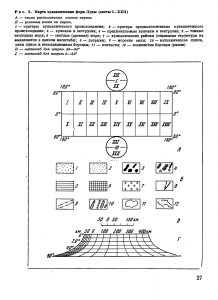
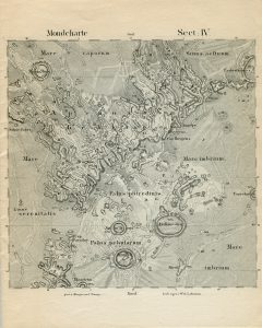
Reference map showing IAU nomenclature, south-up, orthographic projection. Arthur DWG, Agnieray AP, Horvath RA, Wood CA, Chapman CR 1963 The System of Lunar Craters, Quadrant I. Communications of the Lunar and Planetary Laboratory, 2 (30). Published in Communications of the Lunar and Planetary Laboratory 30, 40,50,70, 1963-66 Quadrant I Quadrant II Quadrant IV Also available in […]

Wilkins’ maps of the Moon

Wilkins’ maps of the Moon

Photo: LPOD Sep15 2008. Cartographer: H Percy Wilkins, “the last traditional selenographer” Editions: Early edition with hand lettering, later editions with sans serif and grid. South-up orientation. Orthographic projection. 60 inch map: 1924 200 inch map: 1930 300 inch map of the Moon First edition, 1946.  Third edition, 1951, revisions in 1952, 1954. 25 map sheets, Scale 21.6 miles […]

Archie’s Press Map of the Moon

Archie’s Press Map of the Moon

Cartographer: Archie Archambault Website Planetary Maps from Archie’s Press: The Elements of Space Archie’s Press publishes minimalist “mental” maps that are built from circles. “The circle, our Universe’s softest shape, clearly conveys size and connections.” – Archie says. He created a “Map from the Mind” for dozens of cities, simplifying structures and districts in the simplest […]

Map of the Moon, Swiss World Atlas (2016)

Map of the Moon, Swiss World Atlas (2016)

Topographic map of the Moon Three languages in the three language variants of the Swiss World Atlas (German, French, Italian) Projection: Lambert azimuthal equal-area projection Scale: 1:34,117,800 Cartographer: Stephan Wondrak Publisher: Institut für Kartografie und Geoinformation, ETH Zürich, Atlas Editor: Lorenz Hurni Website: https://schweizerweltatlas.ch/listings/2121/

Moon: AMS Topographic Lunar Map (1962-63)

Moon: AMS Topographic Lunar Map (1962-63)

Contour interval 1000 meters Modified stereographic projection Prepared by the Army Map Service, Corps of Engineers, U.S. Army, Washington, D.C., Compiled in 1963 by stereo-photogrammetric methods, from photography by Paris, McDonald, Mt. WIlson, Yerkes, Pic du Midi Observatories and other base sources. Names generally derived from and referred to “Named Lunar Formations” (1935) by M. Blagg […]

Explanation
Column name Column description
Catalog ID (M) N/A
Title Title of map
Author Name of mapper(s), or author, PI, map editor, illustrator, etc. with roles
Nationality Nationality of author
Start date Year when mapping began / or year or observation
Date of publication Year of publication or completion of manusctipt (empty if not published yet)
Body Target name (planetary body)
Online Online references about the map
Projection Projection of map. 2-hemisphere is shown here.
Scale N/A
Orientation Orientation of map [north up, south up] – only for historic maps (north: cartographic tradition, south: astronomical tradition)
Publication type The type of work that contains the map. [standalone, journal, conference, atlas, book figure, book supplement, book plate, encyclopedia, multisheet, digital]
Type, purpose Type of map purpose [generic, outreach, science, citizen, surface operation (pre mission), landing site (post mission), observer, opposition, index, reference, eclipse/transit/occultation] generic: not defined, outreach: maps for the general public made b
Primary Nomenclature Laguage(s) of nomenclature displayed on the map [Latin, English etc., IAU, informal]. Latin for Latin nomenclature prior to IAU.
Ref (map) Full reference of map publication or publication that contains the map
DOI DOI number of map
ID (publication) ID of map publication or figure number
Origin type If this map is not original, the following codes are used: [L: language variant, N: new print, U: updated edition, C: copied / modified from another map, R: renovation map (digital version of paper map with slight changes), F facsimile. RP: republished in
Origin ID Any maps that this map is based on or copied from. Database ID of original map.
Based on map Name of mapper
Base (spacecraft, telescope) Name of spacecraft / instrument
Original title Title of map in original langage (if not English)
Publisher Name of Publisher; manuscript or self-published. For journals and conferences, the name of the journal or conference.
Coverage Coverage of map [global, hemispheric, regional, local, landing site, landing ellipse, traverse]
Target location IAU name of target feature (if named) or near side, far side etc. (If nothing noted, it is global)
Country Country of Publisher (original/translation)
Type, content Type of map [photo, map, sketch map, drawing, globe, tactile, data]. Data for raster datasets. For vector data, see Feature DB. Drawing: no grid, scale, projection etc.
Image base Base theme of the map [shaded relief, photomosaic, photo, none]
Theme Theme of map [visual, albedo, radar, low sun, topography, elevation, geology, geomorphology, art, nomenclature reference, feature, landing site reference, opposition map, event (eclipse etc) etc.]. Low sun is optical photo with shadows and no albedo. Vis
Technique Cartographic technique [imagemap, datamap, cartographic map, unit map, airbrush, pencil, line drawing/outline, contour lines, DEM, DIM, shaded relief / hillshading, raster data etc.]
Style Details on style
Method Method how the data was obtained
Mapping scale Scale of mapping
Resolution Raster dataset resoltion [m/pixel]
Short Reference Short form of reference to the map publication
GIS / data URL where GIS or original spatial data is
Data provider N/A
Profession Profession of author (for historic maps)
Designator Sheet designator terms following Greeley and Batson (1990) Planetary Mapping. Cambridge University Press. – only if displayed on the map. First letter: target body, 5M: scale, 90/0 etc: center coordinates, OM – orthophotomosaic , T – Topographic data (nom
Control Controlled, semi-controlled, uncontrolled
Note on control Base of control
Series title Title of map series
Number of maps (in work) N/A
Number of quads N/A
Quad ID Quad ID (or quads IDs) contained on the map
Map Diameter N/A
Map width cm N/A
Map height cm N/A
Map width px N/A
Map height px N/A
Base type Type of instrument of observation of base data [naked eye, telescope, spacecraft, space telescope, lander]
Location of copy Library or archive where manuscript or rare copy is kept
Ref (literature) Reference – literature about the map, may be the source of data if the map is not available. Separated with # symbols.
Status (2017) Status of mapping [complete, in progress, in review] (mostly for USGS maps)
Aim Original aim of mapping, if available
Notes Any comments, remarks [Long text, may be multiple paragraphs]
Secondary nomenclature Other languages of the nomenclature
Nomenclature Notes Remarks on nomenclature
Photo note N/A
Reference frame ID from RefFrames
web2 Online references about the map
web3 Online references about the map
web4 Online references about the map
ocentric/ographic Map coordinate [planetographic, planetocentric]
N N/A
S N/A
W 360E N/A
E 360E N/A
W 180 N/A
E 180 N/A
W 360W N/A
R 360W N/A
fig1 N/A
fig1 caption N/A
fig2 N/A
fig2 caption N/A
fig3 N/A
fig3 caption N/A
fig4 N/A
fig4 caption N/A
fig5 N/A
fig5 caption N/A
STATUS N/A
Sum $180