Rectified Lunar Atlas (Supplement to the USAF Lunar Atlas)
Scale 1: 3 500 000
Moon — atlas
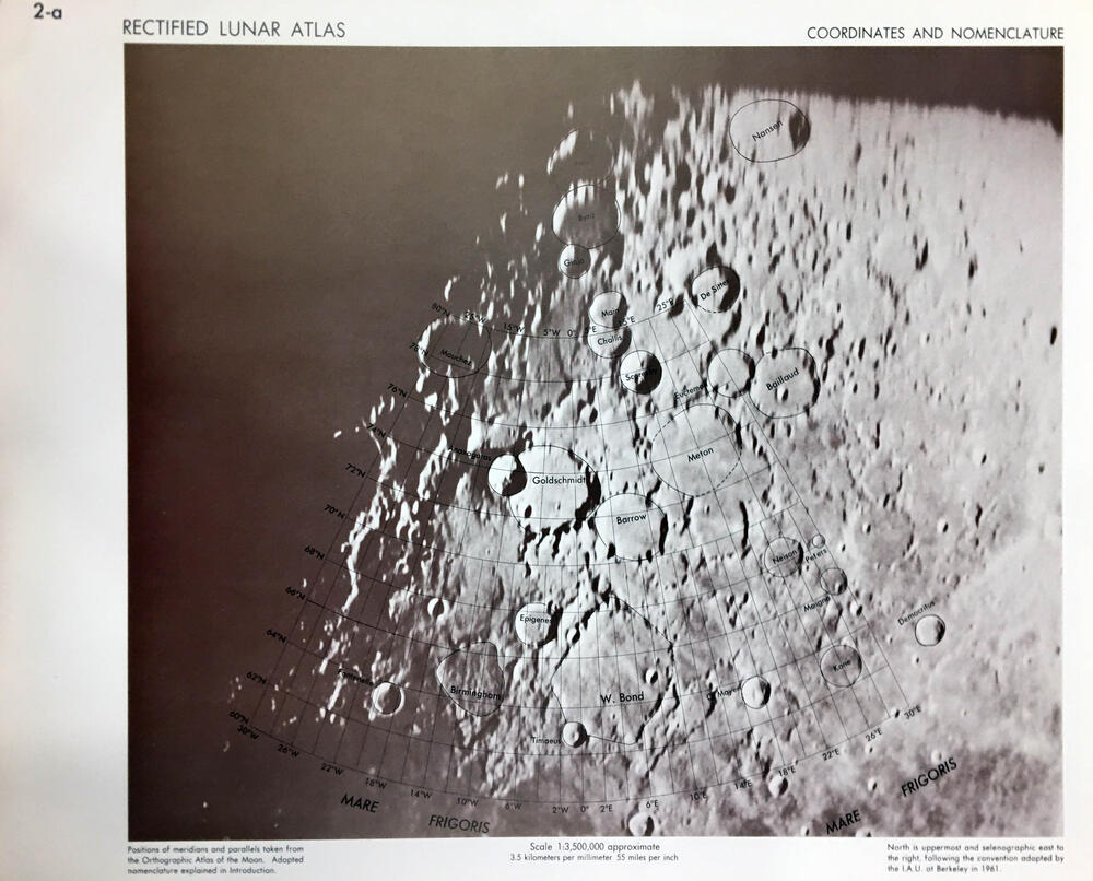


A manuscript page of the Atlas with an actual photograph
RECTIFIED LUNAR ATLAS
Supplement Number Two to the
PHOTOGRAPHIC LUNAR ATLAS
E. A. WHITAKER
G. P. KUIPER
W. K. HARTMANN
L. H. SPRADLEY
North is uppermost and selenographic east to
the right, following the convention adopted by
the I.A.U. at Berkeley in 1961.
INTRODUCTION
The Rectified Lunar Atlas presents a record of the lunar surface based on the best
available photographs, which have been projected onto a globe so as to remove
the usual effects of foreshortening toward the limb. This atlas is part of a series
announced in the text accompanying the Photographic Lunar Atlas (University of
Chicago Press, 1960). Supplement I to that atlas was the Orthographic Atlas of the
Moon (Editions A and B, University of Arizona Press, 1960), which recorded the
orthographic grid and the resulting latitude-longitude grid projected onto a repre-
sentative set of lunar photograph sheets taken from the Photographic Lunar Atlas.
The scale of Supplement I (orthographic) was therefore the same as that of the
original atlas, 1:1.37 million parallel to the limb.
The smaller scale adopted for the Rectified Lunar Atlas, 1:3.5 million, results
in a volume that is more compact and convenient. This scale was a compromise
between the optimum scale for the central portions of the lunar disk (where the
proportions of the original photograph undergo little change) and the limb areas
(where the radial scale was significantly enlarged by the secant factor). Production
of a printed page of the required quality, at this smaller size, was achieved through
the “duplack” process (for each field, one printing plate emphasizes the low
intensities and another the high intensities; the dynamic range is increased by double
printing of each sheet).
The smaller scale adopted for the Rectified Lunar Atlas, 1:3.5 million, results
in a volume that is more compact and convenient. This scale was a compromise
between the optimum scale for the central portions of the lunar disk (where the
proportions of the original photograph underwent little change) and the limb areas
(where the radial scale was significantly enlarged by the secant factor). Production
of a printed page of the required quality, at this smaller size, was achieved through
the “duplack” process (for each field, one printing plate emphasizes the low
intensities and another the high intensities; the dynamic range is increased by double
printing of each sheet).
The process of rectification has been described in a preliminary paper,¹ and
only the principal items of interest are repeated here. The first experiments toward
producing an atlas of this kind were made at the Yerkes Observatory in the fall
of 1958, but a full-scale program was not started until the summer of 1961, upon
completion of the Orthographic Atlas of the Moon at the Lunar and Planetary Lab-
oratory. A precision hemisphere three feet in diameter, the projection screen, was
coated with a fine-grain, dull-white paint having the property of diffuse reflection
without a visible trace of specular reflection. The projector was placed 10–18 meters
from the globe, depending on the plate scale; the geometrical arrangement is shown
in Figures 1 and 2. The plates projected were positives obtained from selected
original negatives by contact printing, using fluoro-dodge technique, with the aid
of a commercially available printer (Kel-O-Way). In this manner the overall contrast
between the maria and the terrae was greatly reduced, allowing the full dynamic
range possessed by the printed plates to be applied to the retention of local contrast,
both in the maria and on the terrae.
Since it was desirable to provide a latitude-longitude grid, the clearest photo-
graph for each field was reprinted with the addition of (a) the latitude-longitude grid
and (b) the standard nomenclature adopted by the IAU with the amendments and
additions described below. The grid was based on that published in Edition B of
the Orthographic Atlas of the Moon. Where possible, the grid of the extreme limb
regions was improved by the use of a new set of position measurements made under
the direction of Mr. D. W. G. Arthur. Even so, the precision of coordinates within
about 10° from the mean limb leaves much to be desired. (The orthographic coordi-
nates, by the nature of their definition, are precise even near the limb, whereas the
computed longitude-latitude grid assumes a lunar radius of constant length, which
is certainly not true for the actual lunar terrain. Precise longitudes and latitudes for
the limb regions will not be available until suitable records have been made from
spacecraft.)
Certain amendments to the IAU nomenclature of 1935 were suggested in the
pamphlet accompanying the Photographic Lunar Atlas. Most of these were adopted
during the IAU meetings in Berkeley in 1961 (Transactions IAU Vol XI B, pp
236–237). In the preparation of the present atlas, the need for further revisions
became apparent, especially in the limb areas. Not only had several large craters,
now well shown, been left unnamed, but the symbols previously assigned to subsidiary
features often appeared inappropriate once the foreshortening was removed. To
remedy these shortcomings, a number of additional names are being proposed for
adoption by the IAU at the 1964 General Assembly through the Chairman of Com-
mission 16, Dr. A. Dollfus. These tentative names have been included for ready
reference. Proposed revisions to IAU nomenclature are listed in Table 1; the pro-
posed new names appear in Table 2.