Copernicus
Scale 1: 1 000 000
Moon — map
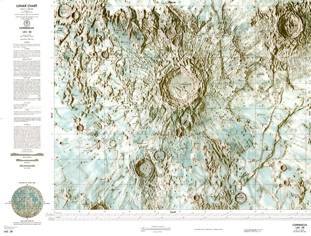
ACIC, 1st Edition, 1961.
Source: Carder, R. W. 1962. Lunar Charting on a Scale of 1:1000000. In: The Moon, (Kopal, Z., and Mikhailov, Z. K., editors) IAU Symposium 14, Academic Press, pp. 117-129, supplement to the book


Lunar chart
Scale 1:1,000,000
Published for
United States Air Force
and
National Aeronautics and Space Administration
by
Aeronautical Chart and Information Center
United States Air Force
St. Louis 18, Missouri
Mercator projection
Scale 1:1,000,000 at 11°00′45″
1st edition July 1961
Notes
This chart was prepared with advisory assistance from Dr. Gerard P. Kuiper and his collaborators, D. W. G. Arthur and E. A. Whitaker.
Control
The position of features on this chart was determined through the use of selenographic control established primarily from the measures of J. Franz and S. A. Saunder as compiled by D. W. G. Arthur and E. A. Whitaker in the Orthographic Atlas of the Moon, edited by Dr. Gerard P. Kuiper, 1960.
Lunar chart
This chart of the Copernicus area, published by the USAF Aeronautical Chart and Information Center (ACIC), represents the state of the art in USAF lunar charting as of July 1961. Contributions of the scientific community have been of major assistance in cartographic production initiated in 1959. Complete and more accurate coverage of the lunar surface at this scale is a continuing program objective.
USAF Aeronautical Chart and Information Center
2nd and Arsenal
St. Louis 18,
Missouri, USA.