Grimaldi’s map of the Moon (1651)

Publication : 1651 Almagestum novum. Bologna: Victorii Benatii.
Cartographer: F. M. Grimaldi
Nomenclature: G. B. Riccioli
Published in: Almagestum novum astronomiam veterem novamque complectens observatiobus aliorum et propriis novisque theorematibus, problematibus ac tabulis promotam in tres tomos distributam / Auctore Ioanne Baptista Ricciolo Bononiae : ex typographia haeredis Victorii Benatii 1665


riccioli1651briccioli1651riccioli_nomenclaturariccioli_gibbariccioli_book

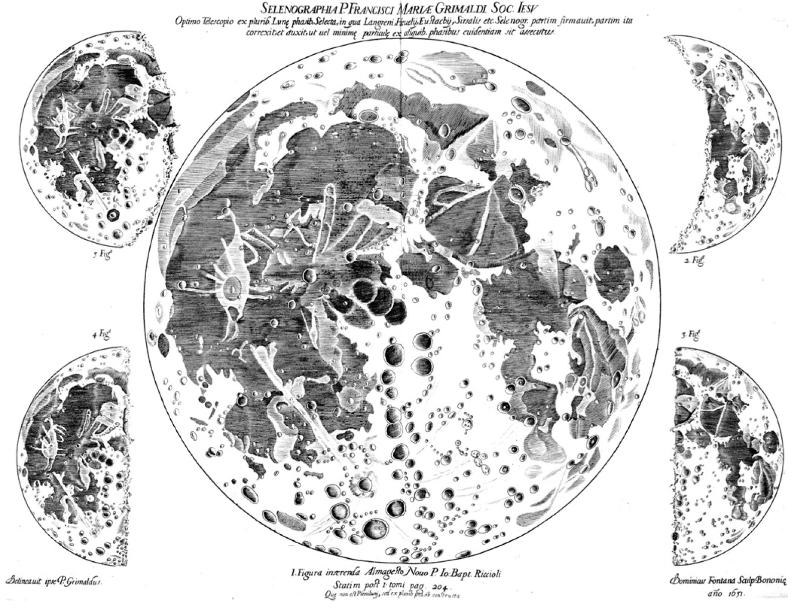
Source: http://www.e-rara.ch/zut/content/titleinfo/140180

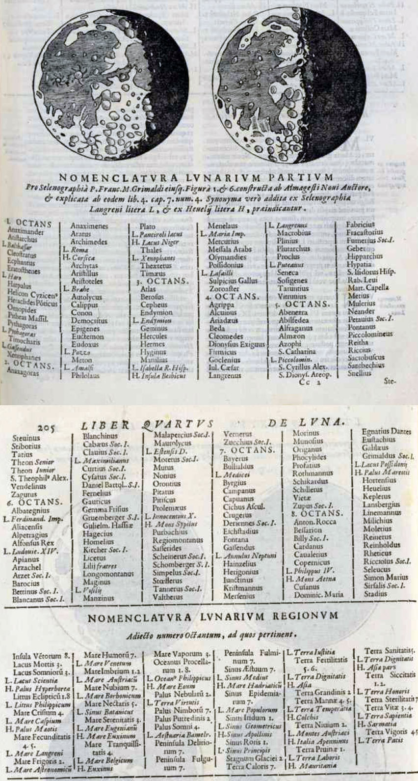
Details on nomenclature:
“Differunt tamen tum in aliis, tum etiam in Nomenclatura partium Lunarium: siquidem Langernus usus est nominibus personarum vel Matheisi, vel dignitate hoc seculo Ecclesiastica Saeculare insignium, vel amicitia sibi coniunctarum.
Regiones vero, tractusque magnos superficiei Lunaris, morali quadam aut ciuili nomenclatura indigentauit.
Sic in eo legas Terram dignitatis … etc.
At Hevelius perinde ac si Luna esset altera tellus, geographica nostratis telluris nomina in lunam transtulit: licet quoad figuram, situm, symmetriam et c. nulla fere sit analogia inter vtriusque superficiem. profitemur tamen, nos ab eorum errore prorsus abhorrere, qui finxerunt, aut Lunam ab aliis hominibus incoli, aut heroum vel etiam aliorum mortalium animas post obitum in Lunae diuersa receptacula, pro diuersis meritis transmigrare.
Regiones autem superficiei Lunaris, quae vel continentes terras, vel maria, lacus, paludes, et c. imitantur, non a speciebus Matheseos, ut optabam (id enim commodiorem minorum partium nomenclaturam impediturum era) denominaui; …
Etsi vero in hoc quasi mero arbitrio aliquam analogiam secutus sum, non ea tamen imbutus sum opinione, ut suspicer nedum existimem, illos potissimum effectus, a quibus praedictam denominationem deprompsi, ex illa portione Lunae pendere, putá, nives ex terra nivium, somnia ex palude somniorum, sive quando certis aspectibus ab aliis sideribus irradiantur. Quamuis enim in hoc thesauro magna vtique mysteria naturae latent, non licet tamen nobis determinatis de illis figmentis, divinorum operum contemplatione ad certos limites indulta imprudenter abuti.
Dixi me non casu praedicta nomina distribuisse in discum Lunae; siquidem in superiori circiter parte antiquiores collocaui, et in primo ac secundo feré Octante plerosque. Physicoastronomos, in tertio et 4. et ad initium quinti ac 6. reliquos antiquiorim; in inferiori parte, qua feré quintum 6. 7. octavum. Octantem complectitur, posui recentiores. Praeterea affinitatem, aut similitudinem vel temporis, vel studiorum, vel secté, aut huiusmodi congruentias quantum fleri potuit affectatus sum. Exempli gratia Metoni Euctemonem, utpote observationum socium, adiunxi; et Plantoni familiares Teéthetum, Timaeum, Archim. neque inde procul Aristotelem ad locaui. Sic item Eudoxo Calippuim, Atlanti Merciruzm, Caesari Sosigenem, Hipparcho Prolemaeum, huic Albategnium, Albategnio Alphonsum, huic Arzachelem et Thebit, his Pirbachium, moxque Regiomontanum Guilelmum Hassiacum, Hainzelium, Safferidem Longomontanum adposiu: non secús ac Copernico suos Rethicum, Moestlinum, Reihmnoldum, et coeteros plerosque illius sectae, quos etiam de industria in procelloso Oceano iactari potiús tanquam natantes insulas ob instabilitatem telluris ab iis assertam, quám consistere malui: et ita in coeteris, ut erudio lectori considerare licebit, analogias non paucas affectaui.”

1651_riccioli_grimaldi

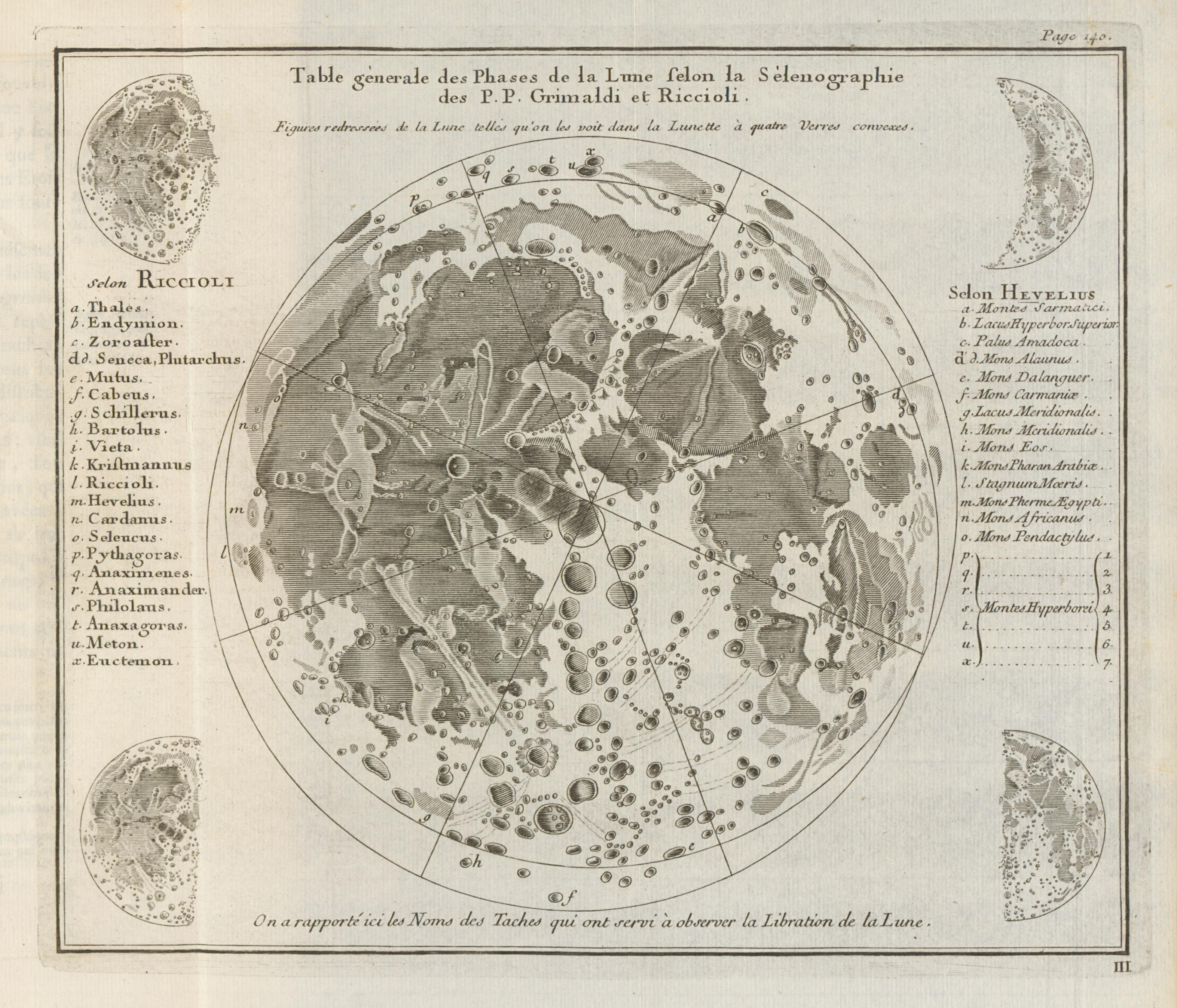
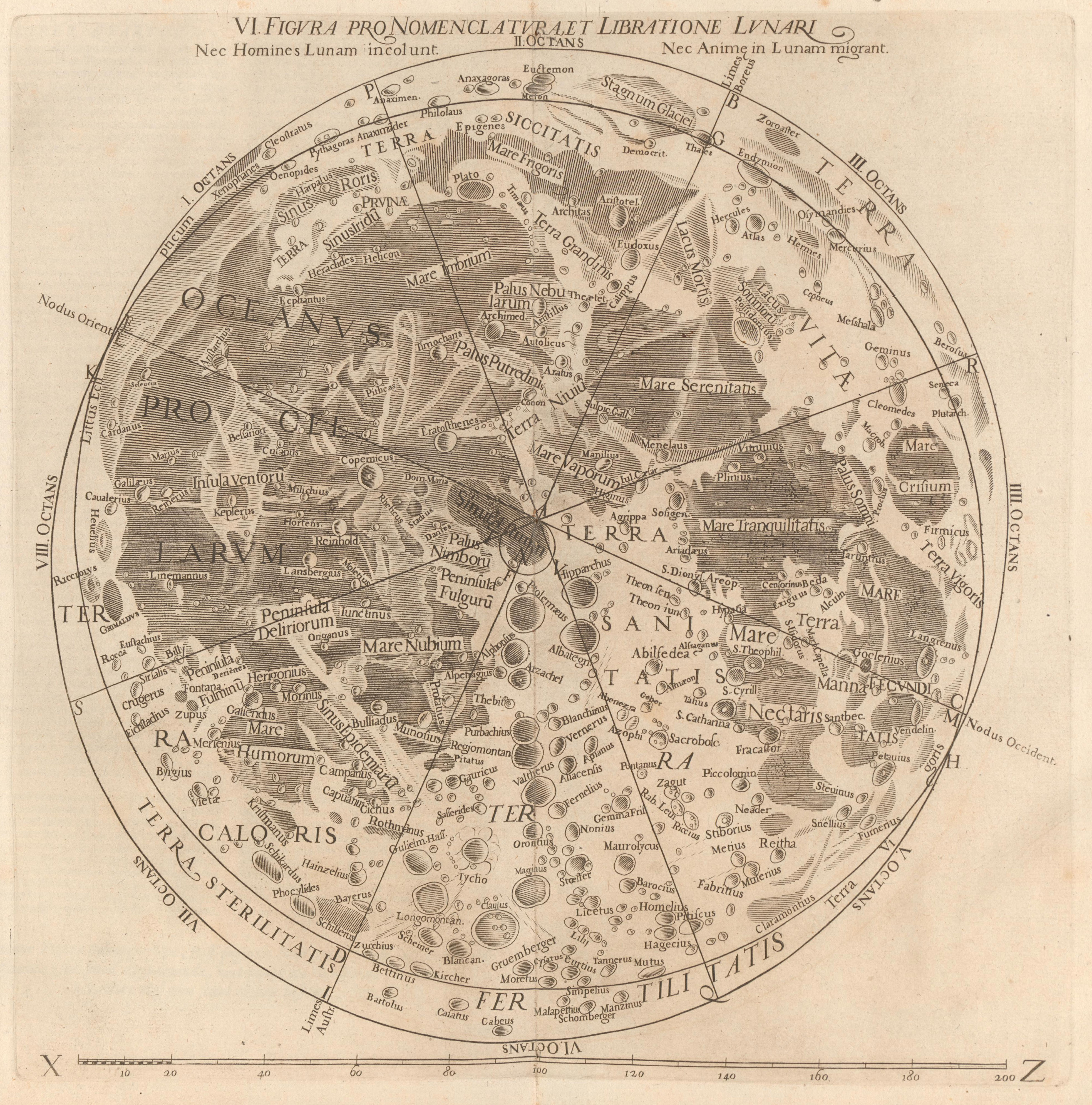
Map of Riccioli and Grimaldi, reproduced by Lemonnier, C.P. 1746; Institutions astronomiques, Paris
With dual nomenclature (Riccioli and Hevelius)
Image  courtesy of Ton Lindemann.

Explanation
Column name Column description
Catalog ID (M) N/A
Title Title of map
Author Name of mapper(s), or author, PI, map editor, illustrator, etc. with roles
Nationality Nationality of author
Start date Year when mapping began / or year or observation
Date of publication Year of publication or completion of manusctipt (empty if not published yet)
Body Target name (planetary body)
Online Online references about the map
Projection Projection of map. 2-hemisphere is shown here.
Scale N/A
Orientation Orientation of map [north up, south up] – only for historic maps (north: cartographic tradition, south: astronomical tradition)
Publication type The type of work that contains the map. [standalone, journal, conference, atlas, book figure, book supplement, book plate, encyclopedia, multisheet, digital]
Type, purpose Type of map purpose [generic, outreach, science, citizen, surface operation (pre mission), landing site (post mission), observer, opposition, index, reference, eclipse/transit/occultation] generic: not defined, outreach: maps for the general public made b
Primary Nomenclature Laguage(s) of nomenclature displayed on the map [Latin, English etc., IAU, informal]. Latin for Latin nomenclature prior to IAU.
Ref (map) Full reference of map publication or publication that contains the map
DOI DOI number of map
ID (publication) ID of map publication or figure number
Origin type If this map is not original, the following codes are used: [L: language variant, N: new print, U: updated edition, C: copied / modified from another map, R: renovation map (digital version of paper map with slight changes), F facsimile. RP: republished in
Origin ID Any maps that this map is based on or copied from. Database ID of original map.
Based on map Name of mapper
Base (spacecraft, telescope) Name of spacecraft / instrument
Original title Title of map in original langage (if not English)
Publisher Name of Publisher; manuscript or self-published. For journals and conferences, the name of the journal or conference.
Coverage Coverage of map [global, hemispheric, regional, local, landing site, landing ellipse, traverse]
Target location IAU name of target feature (if named) or near side, far side etc. (If nothing noted, it is global)
Country Country of Publisher (original/translation)
Type, content Type of map [photo, map, sketch map, drawing, globe, tactile, data]. Data for raster datasets. For vector data, see Feature DB. Drawing: no grid, scale, projection etc.
Image base Base theme of the map [shaded relief, photomosaic, photo, none]
Theme Theme of map [visual, albedo, radar, low sun, topography, elevation, geology, geomorphology, art, nomenclature reference, feature, landing site reference, opposition map, event (eclipse etc) etc.]. Low sun is optical photo with shadows and no albedo. Vis
Technique Cartographic technique [imagemap, datamap, cartographic map, unit map, airbrush, pencil, line drawing/outline, contour lines, DEM, DIM, shaded relief / hillshading, raster data etc.]
Style Details on style
Method Method how the data was obtained
Mapping scale Scale of mapping
Resolution Raster dataset resoltion [m/pixel]
Short Reference Short form of reference to the map publication
GIS / data URL where GIS or original spatial data is
Data provider N/A
Profession Profession of author (for historic maps)
Designator Sheet designator terms following Greeley and Batson (1990) Planetary Mapping. Cambridge University Press. – only if displayed on the map. First letter: target body, 5M: scale, 90/0 etc: center coordinates, OM – orthophotomosaic , T – Topographic data (nom
Control Controlled, semi-controlled, uncontrolled
Note on control Base of control
Series title Title of map series
Number of maps (in work) N/A
Number of quads N/A
Quad ID Quad ID (or quads IDs) contained on the map
Map Diameter N/A
Map width cm N/A
Map height cm N/A
Map width px N/A
Map height px N/A
Base type Type of instrument of observation of base data [naked eye, telescope, spacecraft, space telescope, lander]
Location of copy Library or archive where manuscript or rare copy is kept
Ref (literature) Reference – literature about the map, may be the source of data if the map is not available. Separated with # symbols.
Status (2017) Status of mapping [complete, in progress, in review] (mostly for USGS maps)
Aim Original aim of mapping, if available
Notes Any comments, remarks [Long text, may be multiple paragraphs]
Secondary nomenclature Other languages of the nomenclature
Nomenclature Notes Remarks on nomenclature
Photo note N/A
Reference frame ID from RefFrames
web2 Online references about the map
web3 Online references about the map
web4 Online references about the map
ocentric/ographic Map coordinate [planetographic, planetocentric]
N N/A
S N/A
W 360E N/A
E 360E N/A
W 180 N/A
E 180 N/A
W 360W N/A
R 360W N/A
fig1 N/A
fig1 caption N/A
fig2 N/A
fig2 caption N/A
fig3 N/A
fig3 caption N/A
fig4 N/A
fig4 caption N/A
fig5 N/A
fig5 caption N/A
STATUS N/A
Sum $180